Download
Preview
Add to list
More
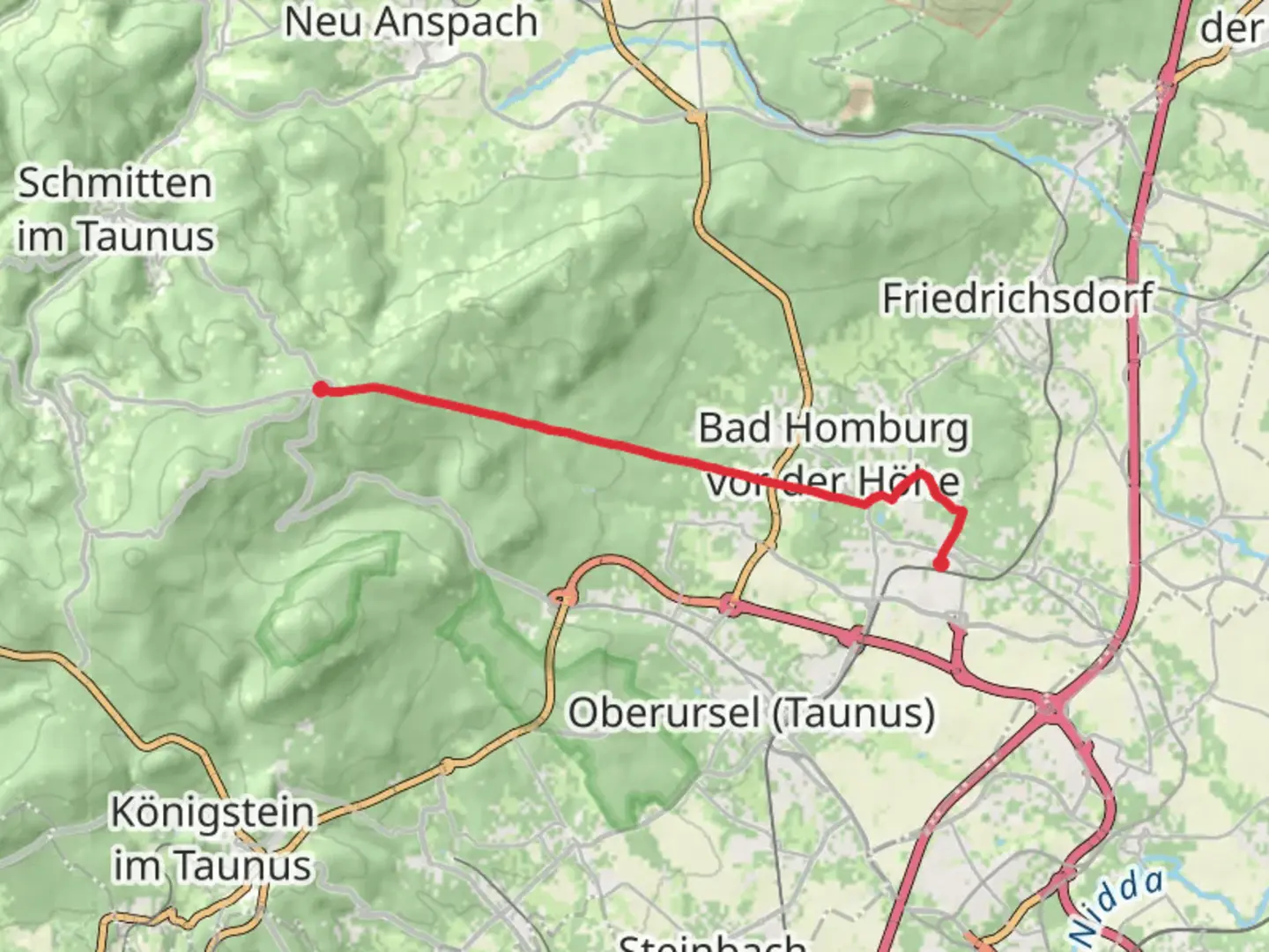
12.0 km
~3 hrs 16 min
534 m
Point-to-Point
“Explore lush forests, historic landmarks, and stunning vistas on the 12 km Taunusklub Route from Bad Homburg to Sandplacken.”
Starting near Hochtaunuskreis, Germany, the trail from Bad Homburg to Sandplacken via the Taunusklub Route offers a delightful 12 km (7.5 miles) journey through the scenic Taunus mountain range. With an elevation gain of approximately 500 meters (1,640 feet), this point-to-point trail is rated as medium difficulty, making it suitable for moderately experienced hikers.
Getting There
To reach the trailhead, you can either drive or use public transport. If driving, set your GPS to Bad Homburg, a well-known town in the Hochtaunuskreis district. There are several parking options available in the town. For those using public transport, Bad Homburg is well-connected by train from Frankfurt, with frequent services running throughout the day. From the Bad Homburg train station, you can either walk or take a local bus to the starting point of the trail.
Trail Navigation
For navigation, it is highly recommended to use the HiiKER app, which provides detailed maps and real-time updates. The trail is well-marked with signs from the Taunusklub, but having a reliable navigation tool will enhance your hiking experience.
Trail Highlights and Landmarks
As you begin your hike, you'll quickly find yourself immersed in the lush forests of the Taunus region. The first few kilometers are relatively gentle, allowing you to ease into the hike. Around the 3 km (1.9 miles) mark, you'll encounter the first significant ascent, which offers stunning views of the surrounding landscape.
Historical Significance
The Taunus region is rich in history, and this trail is no exception. One of the notable landmarks you'll pass is the Saalburg Roman Fort, located approximately 5 km (3.1 miles) into the hike. This well-preserved fort dates back to the Roman Empire and offers a fascinating glimpse into the area's ancient past. It's worth taking a short detour to explore the fort and its museum.
Flora and Fauna
The trail is a haven for nature enthusiasts. The dense forests are home to a variety of wildlife, including deer, foxes, and numerous bird species. Keep an eye out for the European beech trees, which dominate the landscape. In the spring and summer months, the forest floor is carpeted with wildflowers, adding a splash of color to your hike.
Midpoint and Elevation Gain
Around the 6 km (3.7 miles) mark, you'll reach the midpoint of the trail. Here, the elevation gain becomes more noticeable as you ascend towards Sandplacken. The climb is steady but manageable, with several switchbacks easing the gradient. By the time you reach the highest point, you'll have gained approximately 500 meters (1,640 feet) in elevation.
Final Stretch
The final stretch of the trail offers a gentle descent into Sandplacken. This section is particularly scenic, with panoramic views of the Taunus mountains and the Rhine-Main plain in the distance. As you approach Sandplacken, you'll pass through open meadows and small patches of forest, providing a pleasant contrast to the earlier sections of the hike.
Ending Point
The trail concludes in the small village of Sandplacken. From here, you can either arrange for a pick-up or take public transport back to Bad Homburg. Buses run regularly from Sandplacken to nearby towns, making it easy to return to your starting point.
This trail offers a perfect blend of natural beauty, historical landmarks, and moderate physical challenge, making it a rewarding experience for any hiker.

Comments and Reviews
User comments, reviews and discussions about the Bad Homburg to Sandplacken via Taunusklub Route, Germany.
5.0
average rating out of 5
1 rating(s)