Download
3D Flyover
Add to list
More
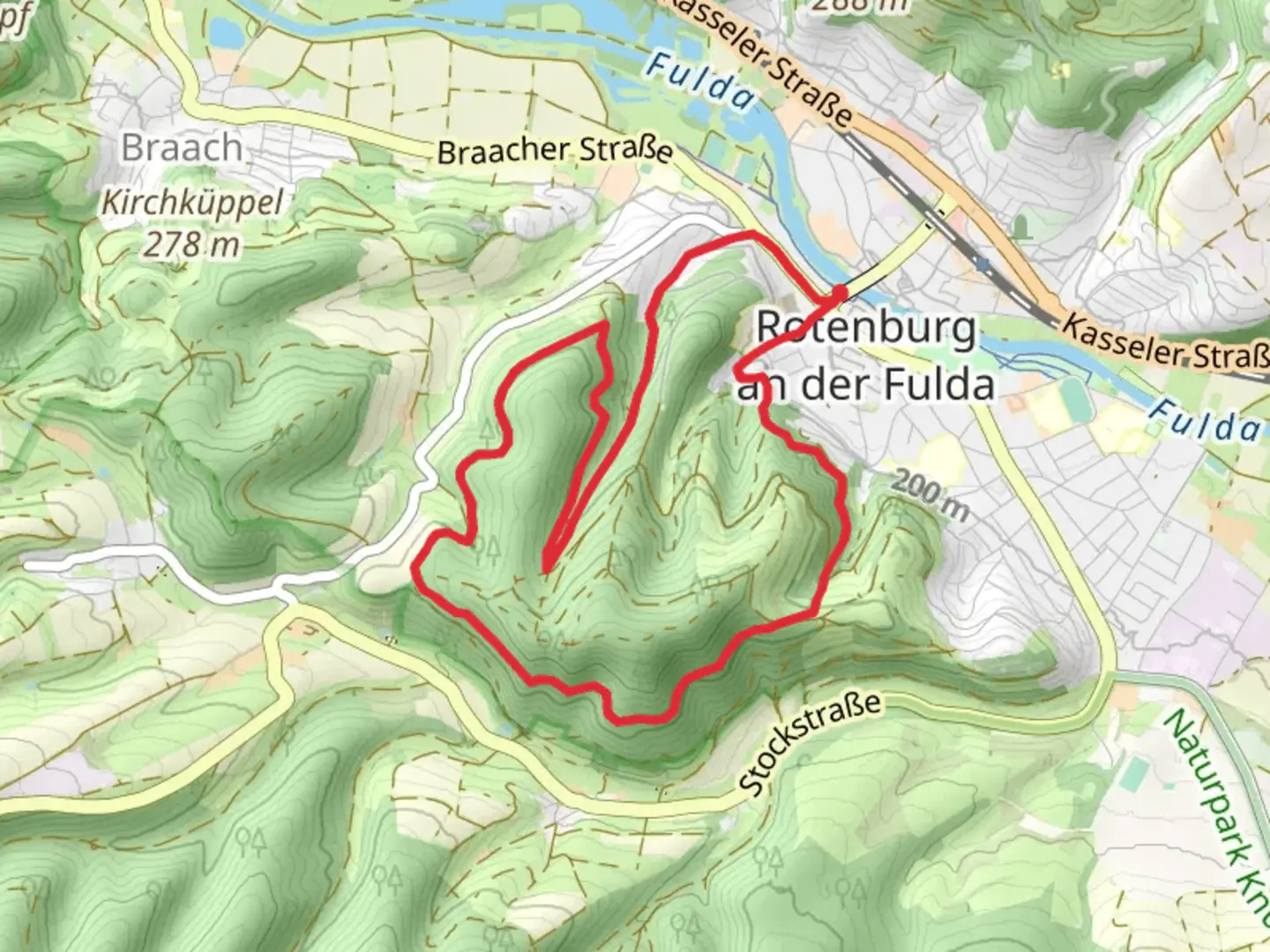
8.5 km
~2 hrs 19 min
380 m
Loop
“Explore lush forests, historic ruins, and panoramic views on this 8 km medium-difficulty loop trail.”
Starting your hike near Hersfeld-Rotenburg, Germany, the Borgmannweg and Rotenburg Wanderweg Loop offers a delightful 8 km (5 miles) journey with an elevation gain of approximately 300 meters (984 feet). This loop trail is rated as medium difficulty, making it suitable for moderately experienced hikers.
Getting There
To reach the trailhead, you can either drive or use public transport. If driving, set your GPS to the nearest known address: Bad Hersfeld, a charming town known for its spa and wellness facilities. From there, follow local signage to the trailhead. For those using public transport, take a train to Bad Hersfeld station. From the station, local buses or a short taxi ride will get you to the starting point.
Trail Overview
The trail begins with a gentle ascent through lush forests, offering a serene start to your hike. As you progress, the path becomes steeper, leading you to the first significant landmark, the ruins of Rotenburg Castle. This medieval castle, perched on a hill, provides panoramic views of the surrounding countryside. The castle dates back to the 12th century and offers a glimpse into the region's rich history.
Flora and Fauna
As you continue, the trail meanders through dense woodlands and open meadows. Keep an eye out for local wildlife, including deer, foxes, and a variety of bird species. The area is also rich in flora, with wildflowers blooming in the spring and summer months, adding a splash of color to your hike.
Midway Point
Approximately 4 km (2.5 miles) into the hike, you'll reach the highest point of the trail, offering stunning views of the Fulda River Valley. This is an excellent spot to take a break, enjoy a snack, and soak in the natural beauty. The elevation gain to this point is around 150 meters (492 feet), making it a rewarding climb.
Historical Significance
The region around Hersfeld-Rotenburg is steeped in history. The trail passes near the town of Rotenburg an der Fulda, known for its well-preserved half-timbered houses and historic town center. This area was a significant trade route in medieval times, and remnants of its storied past can be seen throughout the hike.
Navigation and Safety
For navigation, it's recommended to use the HiiKER app, which provides detailed maps and real-time updates. The trail is well-marked, but having a reliable navigation tool ensures you stay on track. Be prepared for varying terrain, including rocky paths and steep inclines. Proper hiking boots and trekking poles are advisable.
Final Stretch
The descent takes you through more forested areas and eventually loops back to the starting point. The final 4 km (2.5 miles) are relatively easier, with a gradual decline that allows you to enjoy the surrounding nature without too much strain.
This loop trail offers a perfect blend of natural beauty, historical landmarks, and moderate physical challenge, making it a rewarding experience for any hiker.

What to expect?
Activity types
Comments and Reviews
User comments, reviews and discussions about the Borgmannweg and Rotenburg Wanderweg Loop, Germany.
4.0
average rating out of 5
3 rating(s)