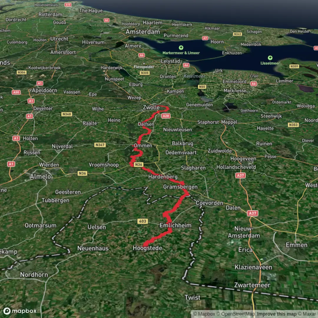
Hoogstede to Zwolle via J.C. Ketterlaan, Rheezerweg, Stuwepad and Holtenbroekerdijk
Download
3D Flyover
Add to list
More
106.9 km
~4 days
234 m
Multi-Day
“A border-to-Zwolle lowland odyssey—canals, fields, and towns—where wind and endurance test you.”
This is a long, mostly flat, point-to-point walk from the Dutch–German border area near Hoogstede into the city of Zwolle, following a patchwork of quiet lanes, farm tracks, canal-side paths, and urban cycleways/footpaths. At roughly 107 km / 66.5 mi with only about 200 m / 656 ft of total ascent, the challenge is less about climbing and more about time on feet, weather exposure, and staying efficient through towns and road crossings. Most hikers will plan this as a 2–3 day outing (or a very long single-day push for fast walkers).
Start location (nearest landmark/address): Hoogstede is a small municipality in Lower Saxony, Germany, right by the Netherlands. A practical “nearest known” start reference is Hoogstede town center near the church area (Kirchstraße, 49846 Hoogstede, Germany)—it’s a clear, navigable anchor point with services nearby.
Finish location (nearest landmark/address): The route’s final approach via Holtenbroekerdijk brings you into Zwolle’s Holtenbroek district; a useful end reference is near Holtenbroekerdijk by the Zwarte Water corridor, Zwolle, Netherlands, with easy onward connections to Zwolle railway station.
Getting to the start (public transport or car)
- By public transport: Hoogstede is rural, so expect a combination of train + bus. The most reliable strategy is to route to a larger rail hub such as Emmen (NL) or Coevorden (NL) / Nordhorn (DE) (depending on your origin), then continue by regional bus/taxi to Hoogstede. Check the last bus times carefully—service can be limited on weekends and evenings.
- By car: Hoogstede is straightforward to reach by regional roads from Nordhorn and the A31/A30 corridor. Park in or near the village center where legal street parking is available; if you’re leaving a car overnight, choose a well-lit, permitted area and avoid blocking farm access.
What the terrain feels like (and why it’s “Easy” but still serious)
Expect very gentle gradients—dikes, canal banks, and reclaimed lowland. Underfoot you’ll see a mix of: - Paved lanes and cycle paths (fast, but harder on feet over multiple days) - Compacted gravel farm tracks - Shorter grassy or dirt sections that can turn soft after rain
Because the elevation gain is low, the main difficulty drivers are: - Distance accumulation (blisters, tendon/foot fatigue) - Wind exposure across open fields and along waterways - Navigation through settlements where paths braid into cycle networks
If you use a navigation app, keep HiiKER handy and zoom in around towns—this is where most wrong turns happen.
Route character by sections (with planning distances)
1) Hoogstede to the first canal-and-farmland corridors (approx. 0–25 km / 0–15.5 mi, ~30–60 m / 100–200 ft gain)
Leaving Hoogstede, the landscape quickly becomes open agricultural lowland: long sightlines, drainage ditches, hedgerows, and scattered farmsteads. You’ll likely be walking beside fields of maize, pasture, and seasonal crops, with frequent small bridges over canals and ditches.
What to look out for - Farm traffic: tractors and delivery vehicles move quickly on narrow lanes; step onto verges early. - Surface changes: paved-to-gravel transitions can be abrupt; watch ankles on loose stone. - Wind chill: even mild temperatures can feel colder in exposed polders.
Nature and wildlife - Expect common lowland birds: lapwings, herons, geese, and gulls near wetter ground; buzzards/kestrels over fields. - Along reedier ditches you may spot moorhens and coots; in quieter stretches, roe deer can appear at field edges around dawn/dusk.
2) Through the Rheezerweg area and toward Hardenberg’s outskirts (approx. 25–55 km / 15.5–34 mi, ~60–110 m / 200–360 ft gain)
As you angle toward the Netherlands’ Overijssel province, the route threads between villages and ribbon development—houses strung along roads—then returns to quieter tracks. The mention of Rheezerweg points you toward the Hardenberg region, where you’ll notice more river-and-canal management infrastructure: embankments, sluices, and straightened waterways.
Landmarks and regional context - This part of Overijssel is shaped by centuries of water control—drainage, dikes, and managed rivers that made farming reliable on low, wet ground. - Town edges often have small industrial estates and canal-side logistics, reflecting the long-standing role of waterways as transport corridors.
Practical planning - This is a good zone to plan a major resupply (supermarkets, bakeries, pharmacies) if your line passes near Hardenberg. - Water is visually everywhere, but treat it as non-potable; plan to refill from taps/shops.
Hazards - Cycle traffic: Dutch cycleways can be busy and fast; walk predictably and keep right unless signage indicates otherwise. - Road crossings: some crossings are wide and open; don’t assume drivers will yield outside marked crossings.
3) Stuwepad and the managed-water landscape (approx. 55–80 km / 34–49.5 mi, ~

Surfaces
Unknown
Asphalt
Concrete
Grass
Sand
Unpaved
Ground
Paved
Cobblestone
Dirt
Wood
Comments and Reviews
User comments, reviews and discussions about the Hoogstede to Zwolle via J.C. Ketterlaan, Rheezerweg, Stuwepad and Holtenbroekerdijk, Germany.
average rating out of 5
0 rating(s)