Download
Preview
Add to list
More
3.7 km
~1 hrs 2 min
172 m
Loop
“The Dragoneye Place Loop offers a scenic 4 km hike with diverse wildlife and historical landmarks.”
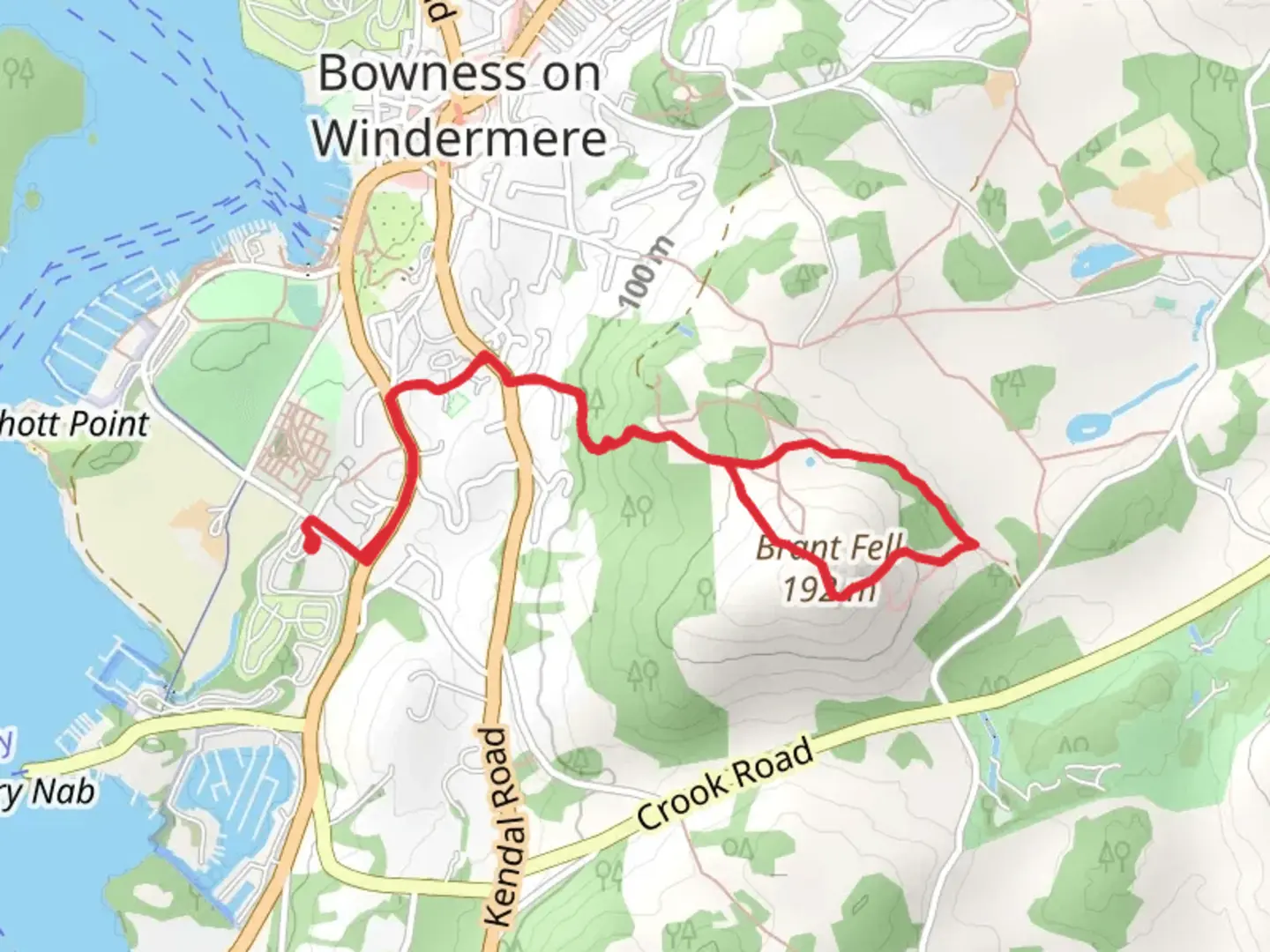
Starting near Westmorland and Furness in England, the Dragoneye Place Loop is a captivating 4 km (2.5 miles) loop trail with an elevation gain of approximately 100 meters (328 feet). This medium-difficulty trail offers a blend of natural beauty, historical landmarks, and diverse wildlife, making it a rewarding experience for hikers.
Getting There
To reach the trailhead, you can drive or use public transport. If driving, set your GPS to the nearest known address: Westmorland and Furness, England. For those using public transport, the nearest significant landmark is the Kendal Railway Station. From there, you can take a local bus or taxi to the trailhead.
Trail Overview
The trail begins with a gentle ascent through a mixed woodland area, where you’ll be greeted by the sounds of chirping birds and rustling leaves. The initial 1 km (0.6 miles) of the trail gains about 30 meters (98 feet) in elevation, making it a manageable start for most hikers.
Historical Significance
As you progress, you’ll come across remnants of ancient stone walls and old farmsteads, offering a glimpse into the region’s agricultural past. This area was historically significant for its role in medieval farming, and you can still see the outlines of old field systems.
Key Landmarks
At around the 2 km (1.2 miles) mark, you’ll reach Dragoneye Place, a natural rock formation that resembles a dragon’s eye. This is a great spot for a short break and some photos. The elevation here is about 70 meters (230 feet) above the starting point, providing a moderate challenge.
Flora and Fauna
The trail is rich in biodiversity. Look out for native wildflowers such as bluebells and foxgloves, especially in the spring. You might also spot red squirrels, deer, and a variety of bird species, including woodpeckers and owls.
Navigation
To ensure you stay on track, it’s advisable to use the HiiKER app, which provides detailed maps and real-time navigation. The trail is well-marked, but having a reliable navigation tool can enhance your hiking experience.
Final Stretch
The last 1 km (0.6 miles) of the trail descends gradually back to the starting point, passing through open meadows and offering panoramic views of the surrounding countryside. The descent is gentle, losing about 30 meters (98 feet) in elevation, making for a pleasant end to your hike.
Practical Tips
- Wear sturdy hiking boots, as the trail can be muddy in sections, especially after rain.
- Bring water and snacks, as there are no facilities along the trail.
- Check the weather forecast before heading out, as conditions can change rapidly.
This loop trail offers a perfect blend of natural beauty, historical intrigue, and moderate physical challenge, making it a must-visit for hikers in the Westmorland and Furness area.

What to expect?
Activity types
Comments and Reviews
User comments, reviews and discussions about the Dragoneye Place Loop, England.
4.33
average rating out of 5
3 rating(s)