Download
Preview
Add to list
More
7.9 km
~2 hrs 9 min
353 m
Loop
“Explore lush woodlands, historic landscapes, and panoramic crag views on this 8 km Grasmere loop trail.”
Starting near Westmorland and Furness, England, this loop trail spans approximately 8 km (5 miles) with an elevation gain of around 300 meters (984 feet). The trailhead is conveniently accessible by car or public transport. If driving, you can park near the village of Grasmere, which is well-signposted and offers several parking options. For those using public transport, Grasmere is served by regular bus services from nearby towns such as Ambleside and Keswick.
Initial Ascent and Butharlyp Howe
The hike begins with a gentle ascent through lush woodland, leading you towards Butharlyp Howe. This initial section is relatively easy, allowing you to warm up as you navigate through the dense canopy of trees. The path is well-marked, but it's always a good idea to have the HiiKER app handy for precise navigation. As you climb, you'll notice the flora gradually changing, with oak and birch trees giving way to more rugged vegetation.
Midway Point and Helm Crag
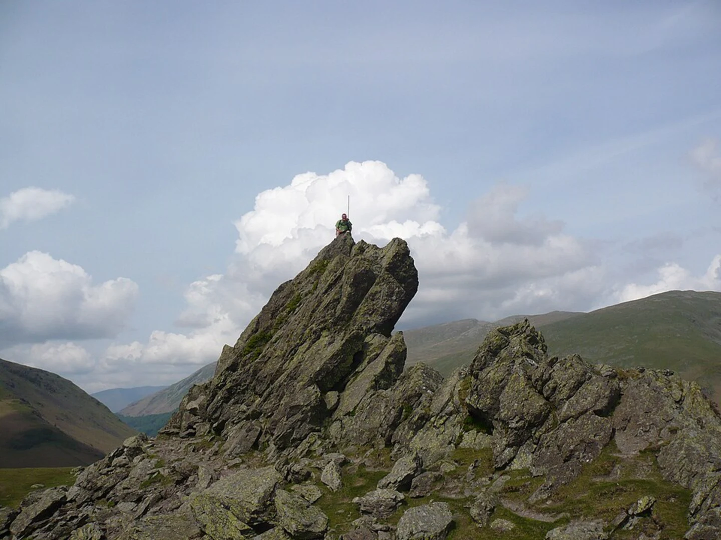
After approximately 3 km (1.9 miles), you'll reach the midway point and start your ascent towards Helm Crag. This section is steeper and more challenging, but the effort is well worth it. Helm Crag, also known as "The Lion and the Lamb" due to its distinctive rock formations, offers panoramic views of the surrounding fells and valleys. The climb to the summit involves some scrambling, so be prepared for a bit of a workout. The elevation gain here is about 200 meters (656 feet) from the base of the crag to the summit.
Historical Significance
The area around Grasmere is steeped in history. The village itself is famously associated with the poet William Wordsworth, who lived here for many years. As you hike, you'll pass by landscapes that inspired some of his most famous works. Helm Crag, in particular, has been a subject of fascination for many artists and writers over the centuries.
Wildlife and Nature
Keep an eye out for local wildlife as you hike. The area is home to red squirrels, deer, and a variety of bird species, including peregrine falcons and buzzards. The diverse plant life ranges from heather and gorse on the higher elevations to bluebells and wild garlic in the woodlands below.
Descent and Return
The descent from Helm Crag is less strenuous but requires careful footing, especially if the ground is wet. The path loops back towards Grasmere, offering a more relaxed walk through open fields and pastures. This section is a great opportunity to take in the serene beauty of the Lake District, with its rolling hills and tranquil streams.
Practical Tips
Given the medium difficulty rating, this trail is suitable for hikers with a moderate level of fitness. Wear sturdy hiking boots, as the terrain can be uneven and rocky, especially near Helm Crag. Weather in the Lake District can be unpredictable, so pack a waterproof jacket and layers. Always carry enough water and some snacks to keep your energy levels up.
Using the HiiKER app will ensure you stay on track and can easily find your way back to the trailhead. Enjoy the hike and the stunning natural beauty that this part of England has to offer.

What to expect?
Activity types
Comments and Reviews
User comments, reviews and discussions about the Butharlyp Howe and Helm Crag, England.
4.5
average rating out of 5
6 rating(s)