Download
Preview
Add to list
More
11.0 km
~2 hrs 59 min
481 m
Loop
“Explore the stunning Wetton Park and Ecton Bridge trail with lush landscapes, historical landmarks, and diverse wildlife.”
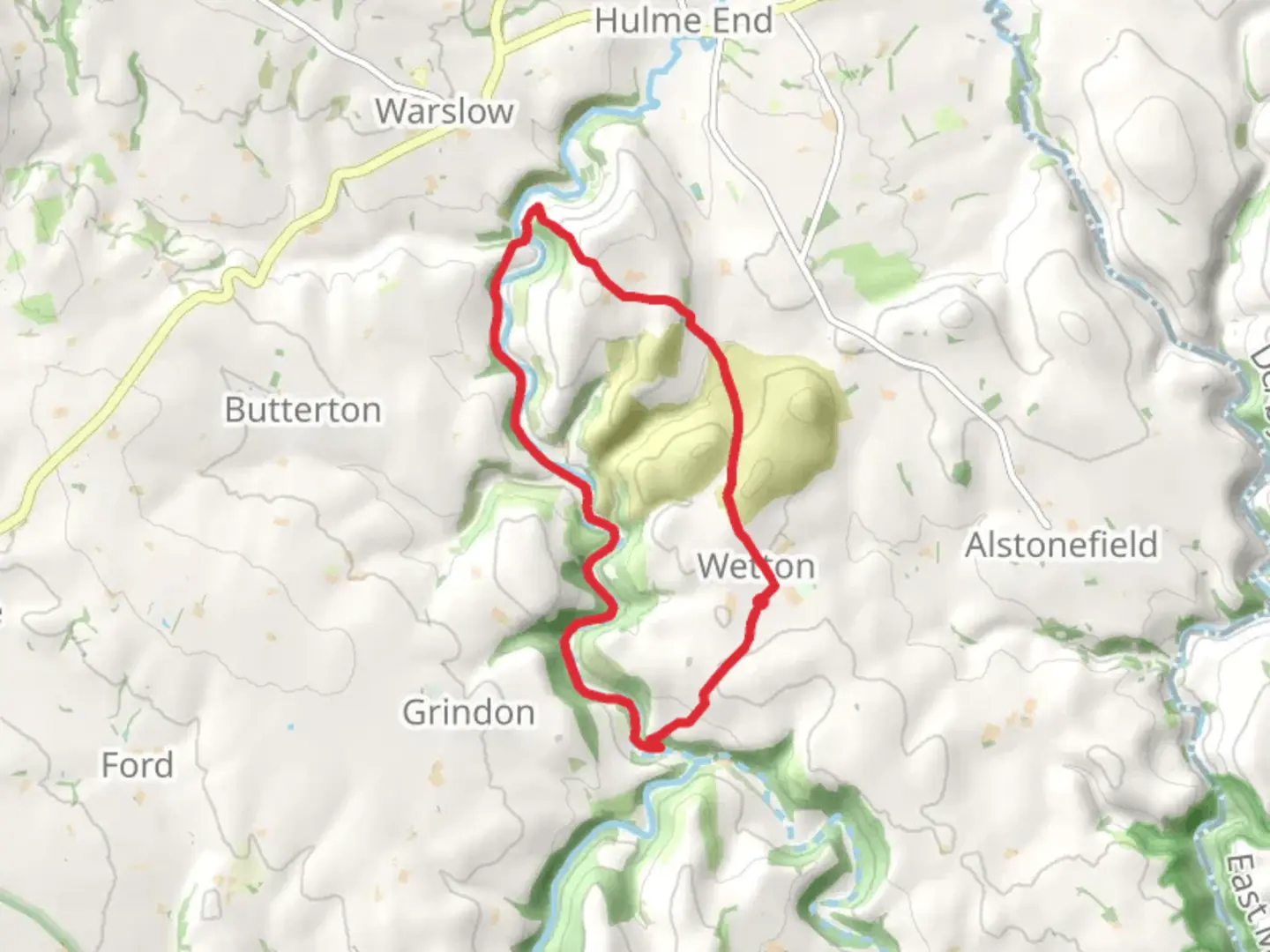
Starting near Staffordshire, England, the Wetton Park and Ecton Bridge trail is a captivating 11 km (approximately 6.8 miles) loop with an elevation gain of around 400 meters (about 1,312 feet). This medium-difficulty trail offers a blend of natural beauty, historical landmarks, and diverse wildlife, making it a rewarding experience for hikers.
Getting There
To reach the trailhead, you can drive or use public transport. If driving, head towards Wetton village, which is well-signposted from major roads in Staffordshire. Parking is available near the village center. For those using public transport, the nearest train station is in Buxton, from where you can take a local bus to Wetton.
Trail Overview
The trail begins in the charming village of Wetton, known for its picturesque stone cottages and tranquil atmosphere. As you set off, you'll quickly find yourself immersed in the lush greenery of the Staffordshire countryside.
Key Landmarks and Sections
Wetton Hill
About 2 km (1.2 miles) into the hike, you'll encounter Wetton Hill. This section involves a moderate climb, gaining approximately 150 meters (492 feet) in elevation. The hill offers panoramic views of the surrounding landscape, including the Manifold Valley. It's a great spot for a short break and some photography.
Thor's Cave
Continuing for another 1.5 km (0.9 miles), you'll reach Thor's Cave, a natural limestone cavern perched high above the valley. The cave has a rich history, with evidence of human habitation dating back to the Stone Age. The climb up to the cave is steep but manageable, and the views from the entrance are well worth the effort.
Manifold Way
Descending from Thor's Cave, the trail intersects with the Manifold Way, a popular walking and cycling path that follows the route of a former railway line. This section is relatively flat and easy, providing a pleasant contrast to the earlier climbs. You'll follow the Manifold Way for about 3 km (1.9 miles), passing through scenic woodlands and meadows.
Ecton Hill and Bridge
At around the 7 km (4.3 miles) mark, you'll begin the ascent of Ecton Hill, gaining another 150 meters (492 feet) in elevation. Ecton Hill is historically significant due to its rich mining history. Copper and lead were extracted here as far back as the Bronze Age, and remnants of the old mines can still be seen. After descending the hill, you'll cross Ecton Bridge, a charming stone bridge over the River Manifold.
Flora and Fauna
The trail is home to a variety of wildlife, including deer, foxes, and numerous bird species. The woodlands are rich with oak, ash, and beech trees, while the meadows are dotted with wildflowers in the spring and summer months.
Navigation and Safety
Given the varied terrain and historical sites, it's advisable to use a reliable navigation tool like HiiKER to stay on track. The trail is well-marked, but having a digital map can be very helpful, especially in the more remote sections.
Final Stretch
The final 2 km (1.2 miles) of the loop take you through peaceful farmland and back into Wetton village. This section is relatively flat and provides a gentle end to the hike. Once back in Wetton, you can relax at one of the local pubs or cafes, reflecting on the diverse landscapes and rich history you've experienced.
This trail offers a perfect blend of natural beauty, historical intrigue, and moderate physical challenge, making it a must-do for hikers in the Staffordshire area.

What to expect?
Activity types
Comments and Reviews
User comments, reviews and discussions about the Wetton Park and Ecton Bridge, England.
4.0
average rating out of 5
2 rating(s)