
Download
3D Flyover
Add to list
More
4.2 km
~58 min
77 m
Loop
“Sea-swept cliffs, wildflowers, and storied waters make this short Wembury loop quietly memorable.”
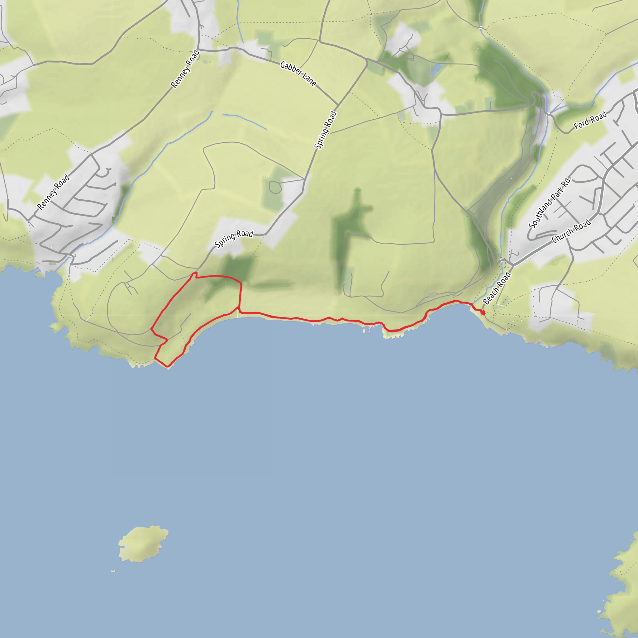
This easy coastal loop of around 4 km / 2.5 miles with roughly 100 m / 330 ft of ascent explores one of South Devon’s most attractive stretches of shoreline, combining open sea views, low cliff paths, pastureland, and a strong sense of maritime history. The route is generally short and manageable, but the coastal setting means it can feel more exposed than the distance suggests, especially in wind or wet weather. Expect a mix of well-trodden footpaths, sections of the South West Coast Path, grassy tracks, and some uneven ground where mud, roots, or worn cliffside paths can make footing less predictable.
The walk begins near Wembury Beach and the village of Wembury, close to St Werburgh’s Church and the National Trust parking area, which is the most practical landmark for planning arrival. If approaching by car, the usual access is via the roads south from Plymouth through Plymstock and onward to Wembury village, where parking near the beach is the standard starting point. Spaces can fill quickly in warmer months and on weekends, so arriving early is wise. For public transport, buses from Plymouth typically provide the most useful connection toward Wembury, though services can be limited compared with urban routes, so checking current timetables before setting out is important. If using navigation tools for the walk itself, HiiKER is the best reference for staying on the intended loop and checking junctions around the coast path and inland return.
From the start, the route quickly establishes its coastal character. The opening section usually feels gentle, with only modest climbing at first, but the undulating nature of the headland means the total ascent builds gradually rather than arriving in one long hill. The sea is a constant companion, and on clear days the views stretch widely across Plymouth Sound and the English Channel. The cliffs here are not mountainous, but they are dramatic in their own way—low, rugged, and weather-shaped, with rocky outcrops and patches of maritime grassland that give the landscape a distinctly southwestern feel.
Terrain and route character
Although rated easy, this is not a completely flat promenade-style walk. Hikers should expect short rises and dips as the path follows the contours of the coast, with the 100 m / 330 ft of climbing spread across the loop. The path can be narrow in places, particularly where it hugs the cliff edge or passes through vegetation. After rain, grassy sections may become slippery, and exposed stretches can feel more serious in strong winds. Good walking shoes are usually enough in dry conditions, but boots can be helpful in winter or after prolonged wet weather.
The coastal sections are the highlight, especially around Wembury Point, where the land projects into the sea and gives a broad outlook over the water and back toward the surrounding coves and fields. Inland portions of the loop tend to be quieter and more enclosed, passing through hedged lanes, pasture edges, or farmland paths that contrast nicely with the openness of the coast. This change in atmosphere is part of what makes the route satisfying despite its short length.
Because this is a cliff-top walk, extra care is needed near edges, particularly with children or dogs. Coastal erosion can alter path margins over time, and even on apparently broad sections the ground near the edge may be less stable than it looks. In mist or heavy rain, visibility can drop enough to make junctions less obvious, so having the route loaded on HiiKER is useful even for a relatively short outing.
Landmarks, wildlife, and coastal scenery
One of the most notable landmarks near the start is St Werburgh’s Church, a striking historic church set close to the coast and well known for its dramatic position above the sea. It adds immediate character to the walk and helps anchor the route in the long human history of this shoreline. Nearby Wembury Beach is also significant, known for its rocky foreshore and rock pools, which are among the most interesting natural features in the area. At low tide, these pools can reveal crabs, small fish, sea anemones, and other marine life, making the area especially appealing for families or anyone interested in coastal ecology.
The headland and surrounding coast fall within an area valued for wildlife, and walkers may spot seabirds riding the wind along the cliffs or feeding offshore. Depending on season and conditions, gulls, cormorants, and other coastal birds are common, while the grassland and hedgerows inland can support butterflies and smaller songbirds. The marine environment off this coast is also rich, and while sightings are never guaranteed, the wider South Devon coast is known for occasional views of seals and other marine life.
The vegetation reflects the exposed maritime setting. In spring and summer, cliff-top flowers and salt-tolerant grasses can brighten the route, while the inland hedgebanks often hold a mix of wildflowers, ferns, and dense greenery. Even on a short walk, the transition between rocky shore, open headland, and enclosed farmland gives a strong sense of ecological variety.
Historical significance of the area
This stretch of coast sits within a region shaped for centuries by fishing, farming, seafaring, and coastal defense. Plymouth Sound, visible from much of the route, has long been one of the most historically important natural harbours in England. Its strategic role connects the landscape to naval history, trade, exploration, and wartime defense. Looking out from Wembury Point, hikers are effectively looking across waters that have seen everything from routine coastal traffic to major naval movements over many generations.
The church at Wembury is itself part of that historical texture, reflecting the long-established settlement of the area and the importance of the coast to local communities. The surrounding patch
What to expect?
Surfaces
Unknown
Ground
Gravel
Concrete
Comments and Reviews
User comments, reviews and discussions about the Wembury Point Loop via SWCP, England.
average rating out of 5
0 rating(s)


