Download
3D Flyover
Add to list
More
31.2 km
~7 hrs 12 min
577 m
Multi-Day
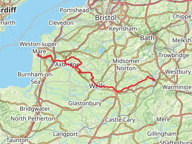
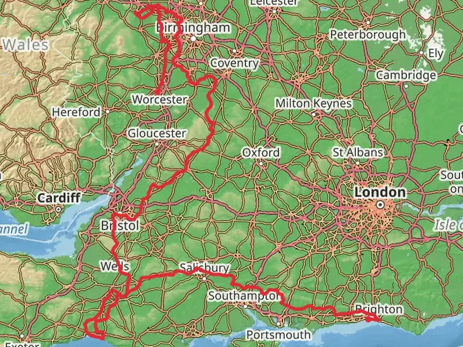
The East Mendip Way is a 31.2 km trail that starts in Mendip, Somerset, England. Based on our data, the hike is graded as Easy. For information on how we grade trails, please read measuring the difficulty of a hiking trail on hiiker. Also, check our latest community posts for trail updates. This hike can be completed in approx 7 hrs 13 mins. Caution is advised on trail times as this depends on multiple variables. For more info read about how we calculate hike time.

What to expect?
Activity types
Frequently asked questions
How long does the East Mendip Way take to walk from Wells to Frome?
The East Mendip Way is 31.25 km, or about 19.4 miles, from Wells to Frome. Most walkers complete it in 1 long day or split it into 2 easier days, often using Shepton Mallet or Waterlip as a break point. The route is generally classed as easy, but the full distance and 577 m of climbing still make it a solid outing.
Where does the East Mendip Way start and finish?
The East Mendip Way runs east across Somerset from Wells to Frome. The signed route begins around Cathedral Green by Wells Cathedral and the Wells & Mendip Museum, then finishes in central Frome. It forms the eastern half of the wider Mendip Way long-distance route.
Can the East Mendip Way be walked in sections instead of as one trip?
Yes. The East Mendip Way is commonly broken into shorter sections rather than walked all at once. The current Mendip Way guide splits the east section into Wells to Shepton Mallet at 6.1 miles, Shepton Mallet to Waterlip at 2.6 miles, Waterlip to Great Elm at 7.5 miles, and a final leg into Frome, which makes it practical as a 2- to 4-stage walk.
What towns and landmarks does the East Mendip Way pass on the way to Frome?
The East Mendip Way links Wells, Shepton Mallet, Waterlip, Great Elm, and Frome. Notable features on the route include Wells Cathedral, Tor Hill Nature Reserve, King’s Castle Wood, Charlton Viaduct near Shepton Mallet, and Cranmore Tower above the woodland section before Great Elm. There are also views back toward Glastonbury Tor on the Shepton Mallet side.
Is the East Mendip Way easy, and what is the terrain like?
The East Mendip Way is rated easy overall, but that does not mean flat. Across 31.25 km it gains 577 m, with a mix of pavement leaving Wells, field paths, woodland tracks, hedge-lined lanes, minor roads, steps, gates, and stiles. Some sections are gentle, but there are steeper gradients and muddy ground after wet weather.
Is there public transportation at the ends of the East Mendip Way?
Yes. The East Mendip Way is one of the more practical point-to-point walks in Somerset because both ends are in towns with bus links. Wells has bus services to places including Bath, Bristol, Frome, Shepton Mallet, Street, and Weston-super-Mare, and Frome has both bus services and a railway station, which makes return travel easier without a car.
Can dogs go on the East Mendip Way?
Dogs can generally be taken on public rights of way in Somerset, so much of the East Mendip Way is suitable for walking with a dog. The route crosses farmland and uses gates, kissing gates, and stiles in places, so close control is important, especially around livestock. Some sections may be awkward for larger dogs because of the path furniture.
Comments and Reviews
User comments, reviews and discussions about the East Mendip Way, England.
5.0
average rating out of 5
1 rating(s)