Download
Preview
Add to list
More
51.0 km
~2 days
1285 m
Multi-Day
“"The Hyndburn Clog trail: a historic, scenic hike through Lancashire's diverse landscapes and wildlife."”
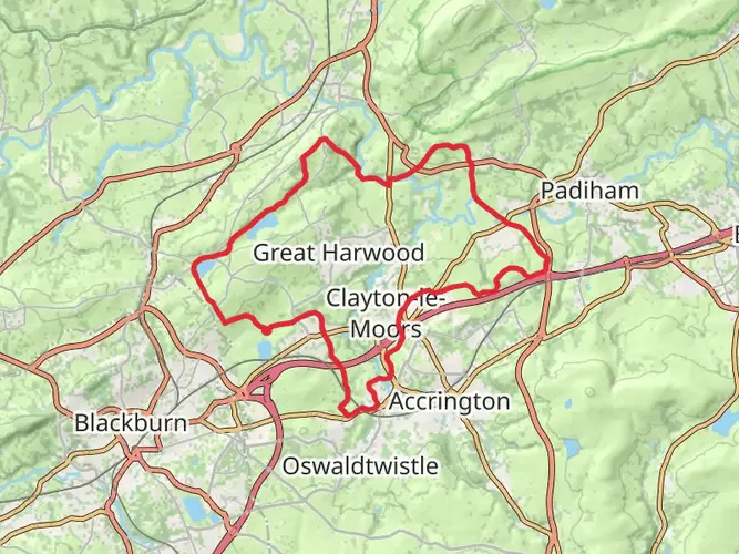
The Hyndburn Clog is a captivating loop trail that spans approximately 51 kilometers (around 31.7 miles) with an elevation gain of roughly 1200 meters (about 3937 feet), nestled near Lancashire, England. This medium-difficulty hike offers a blend of scenic vistas, historical sites, and diverse wildlife, making it an enriching experience for avid hikers.
Getting to the Trailhead
To reach the starting point of the Hyndburn Clog, hikers can drive to the vicinity of Lancashire, where parking is available near the trailhead. For those preferring public transport, local buses serve the area, and the nearest train stations are within a reasonable distance, providing access from major cities. Once at the trailhead, hikers can prepare for their journey, ensuring they have all necessary provisions and equipment.
Navigating the Trail
Equipped with the HiiKER app, hikers can confidently navigate the trail, which is well-marked and traverses a variety of terrains. The app provides detailed maps and waypoints, ensuring that even those new to the trail can find their way without difficulty.
Landmarks and Historical Significance
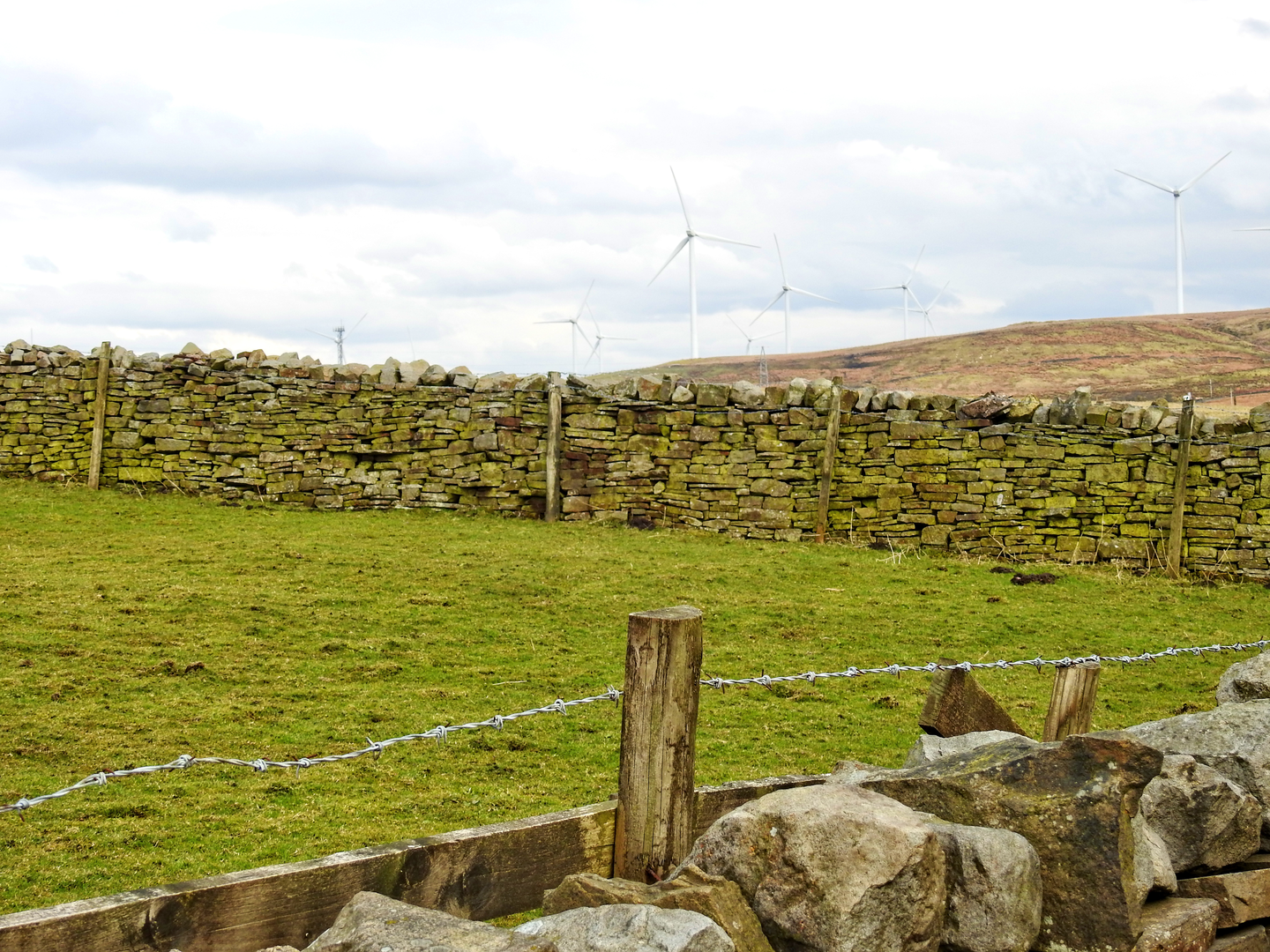
As hikers embark on the Hyndburn Clog, they will encounter a tapestry of landscapes, from rolling hills to dense woodlands. The trail passes through areas steeped in history, such as remnants of the Industrial Revolution, including old mills and cobbled paths that were once trodden by workers, known as 'cloggers', who wore wooden-soled shoes.
Nature and Wildlife
The region is home to an array of wildlife, with opportunities to spot birds of prey circling above and native flora along the path. The changing seasons bring different hues to the landscape, with spring blossoms and autumnal leaves providing a colorful backdrop to the journey.
Elevation and Distance
The trail's elevation gain is gradual, with the most significant ascents occurring in the first half of the loop. Hikers should be prepared for a cumulative elevation gain of around 1200 meters, which is interspersed with flatter sections that provide a respite from the climbs.
Preparation and Planning
Before setting out, hikers should ensure they have adequate water, as there are limited sources along the route. Weather-appropriate clothing is essential, as conditions can change rapidly. It's also advisable to carry a first-aid kit and a means of communication in case of emergencies.
Conclusion
The Hyndburn Clog is a trail that offers more than just a physical challenge; it's a journey through history, nature, and the heart of Lancashire's countryside. With careful preparation and the aid of navigation tools like HiiKER, hikers can immerse themselves in the beauty and heritage of this enchanting loop.

What to expect?
Activity types
Frequently asked questions
How long does the Hyndburn Clog take to walk as a multi-day hike?
The Hyndburn Clog is a 50.96 km loop with about 1,285 m of climbing, so most walkers split it over 2 to 3 days. Strong hikers sometimes complete it in a long single day, but the route is better suited to a weekend outing because it circles a wide stretch of Hyndburn and includes repeated ups and downs rather than one steady climb.
Where does the Hyndburn Clog start and finish in Lancashire?
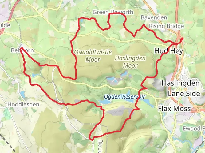
The Hyndburn Clog is a circular route, so it finishes where it starts. A commonly used start point is Stanhill in Hyndburn, postcode BB5 4PT, and the loop then works around landmarks including Belthorn, Calf Hey Reservoir, Ogden Reservoir, Holden Wood Reservoir, Rising Bridge, Hapton, Read, Rishton, and Oswaldtwistle before returning to the start area.
What landmarks and reservoirs are on the Hyndburn Clog route?
The Hyndburn Clog passes a notably varied set of Lancashire landmarks for a 51 km circuit. Named points associated with the route include Belthorn, Causeway Height, Calf Hey Reservoir, Ogden Reservoir, Holden Wood Reservoir, Mitchell's House Reservoir, Hameldon Common, Dean Clough Reservoir, Parsonage Reservoir, Rishton, and Oswaldtwistle, with sections also linked to the Leeds and Liverpool Canal.
Is the Hyndburn Clog difficult, and is it suitable for beginners?
The Hyndburn Clog is graded easy, but that rating needs context because it is still a 50.96 km multi-day loop with 1,285 m of ascent. The walking is generally more about stamina and route management than technical ground, so it suits beginners with good fitness and some experience of full-day hikes better than first-time walkers.
Can the Hyndburn Clog be done in one day?
Yes, the Hyndburn Clog can be done in one day by very fit walkers, but it is a demanding day out at just under 51 km. For most people, the combination of distance and 1,285 m of ascent makes it more realistic as a 2-day or 3-day trip, especially if there is slow going on moorland or reservoir-side sections.
What kind of scenery does the Hyndburn Clog pass through?
The Hyndburn Clog mixes moorland, reservoir edges, woodland, canal-side stretches, and towns and villages around Hyndburn. The route links places such as Hameldon Common, Belthorn, Read, Rishton, and Oswaldtwistle, so the scenery changes regularly between open upland ground, industrial-era landscapes, and lower-level waterside sections.
Comments and Reviews
User comments, reviews and discussions about the Hyndburn Clog, England.
4.2
average rating out of 5
5 rating(s)