Download
Preview
Add to list
More
21.6 km
~5 hrs 8 min
488 m
Loop
“From lush landslips to soaring views, this vibrant loop reveals the Isle of Wight’s wild coastal heart.”
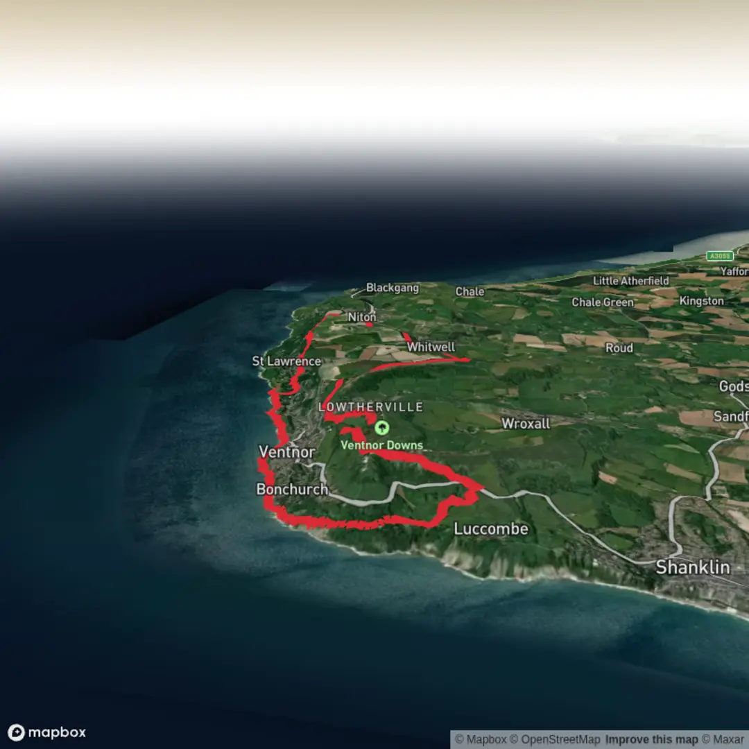
Starting from the charming coastal village of Ventnor on the Isle of Wight, this 22 km (about 13.7 miles) loop with approximately 500 metres (1,640 feet) of elevation gain offers a diverse journey through dramatic landslips, sweeping bays, and the open grasslands of Rew Down. The trailhead is conveniently located near Ventnor Esplanade, a well-known promenade with easy access to public transport and parking. Buses from Newport and Shanklin stop at Ventnor, and drivers can find parking along the Esplanade or in nearby public lots.
Coastal Cliffs and The Landslip
The route quickly ascends from the seafront, winding through the lush undercliff region known as The Landslip. This area is famous for its geological instability, with dramatic evidence of past landslides visible in the uneven terrain and exposed rock faces. The path here can be narrow and muddy after rain, so sturdy footwear is essential. Keep an eye out for rare ferns and wildflowers thriving in the sheltered microclimate, and listen for the calls of green woodpeckers and warblers in the dense woodland.
Wheelers Bay and Mount Bay
After about 5 km (3 miles), the trail opens up to panoramic views over Wheelers Bay, a favorite spot for fossil hunters and beachcombers. The bay’s shingle beach is accessible via a steep path, and the area is dotted with remnants of Victorian sea defenses. Continuing along the coast, Mount Bay offers a quieter stretch with opportunities to spot seabirds such as cormorants and oystercatchers. The cliffs here are a nesting site for peregrine falcons, so binoculars are recommended for bird enthusiasts.
Rew Down and Open Grasslands
Turning inland around the 13 km (8 mile) mark, the route climbs steadily onto Rew Down, a Site of Special Scientific Interest (SSSI) known for its chalk grassland habitat. This open expanse is home to grazing cattle and a rich variety of butterflies, including the Adonis blue and chalkhill blue. The summit provides sweeping views back toward the coast and across the island’s rolling interior. The grassland is crisscrossed with well-marked paths, but navigation can be tricky in fog—using HiiKER for GPS guidance is highly recommended.
Historical Highlights and Practical Tips
The region is steeped in history, with evidence of Bronze Age burial mounds on Rew Down and Victorian-era tunnels near Ventnor. The undercliff area was once a fashionable retreat for 19th-century visitors seeking the health benefits of the mild climate. Along the way, you’ll pass remnants of old smuggling routes and lookout points used during the Napoleonic Wars.
Water sources are limited along the route, so carry enough for the full distance. There are several cafes and public toilets in Ventnor at the start and end of the loop, but facilities are sparse elsewhere. The trail is best tackled in dry weather due to slippery sections on the landslip and chalk paths. Dogs are welcome but should be kept on leads near livestock and cliff edges.
For navigation, download the route on HiiKER to ensure you stay on track, especially in the more remote sections of Rew Down and the undercliff. This loop offers a rewarding mix of coastal drama, wildlife, and history, making it a standout hike on the Isle of Wight.

Surfaces
Unknown
Unpaved
Grass
Asphalt
Concrete
Gravel
Dirt
Ground
Wood
Comments and Reviews
User comments, reviews and discussions about the The Landslip, Wheelers Bay, Mount Bay and Rew Down Loop, England.
average rating out of 5
0 rating(s)