Download
3D Flyover
Add to list
More
38.1 km
~2 days
1471 m
Multi-Day
“Embark on the Snježnik Mountain Trail for a historically rich, scenic hike through Croatia's diverse terrains.”
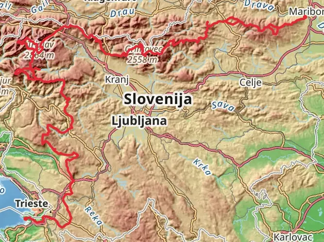
The Snježnik Mountain Trail offers an invigorating hike through the diverse landscapes of Primorje-Gorski Kotar County, Croatia. Spanning approximately 38 kilometers (about 23.6 miles) with an elevation gain of roughly 1400 meters (about 4593 feet), this point-to-point trail is a medium-difficulty adventure that attracts both seasoned hikers and those looking to immerse themselves in the natural beauty of the region.
Getting to the Trailhead To reach the starting point of the Snježnik Mountain Trail, hikers can drive to the vicinity of Primorje-Gorski Kotar County. The trailhead is accessible by local roads, and parking is available near the entrance. For those opting for public transportation, buses from nearby cities such as Rijeka can drop you off at a stop close to the trailhead. From there, a short walk will bring you to the starting point.
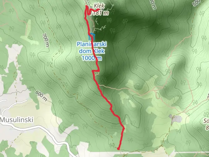
Navigating the Trail As you embark on the trail, it's advisable to use a reliable navigation tool like HiiKER to keep track of your progress and ensure you're following the correct path. The trail is well-marked, but having a digital map can be invaluable, especially in areas where the trail may become less distinct.
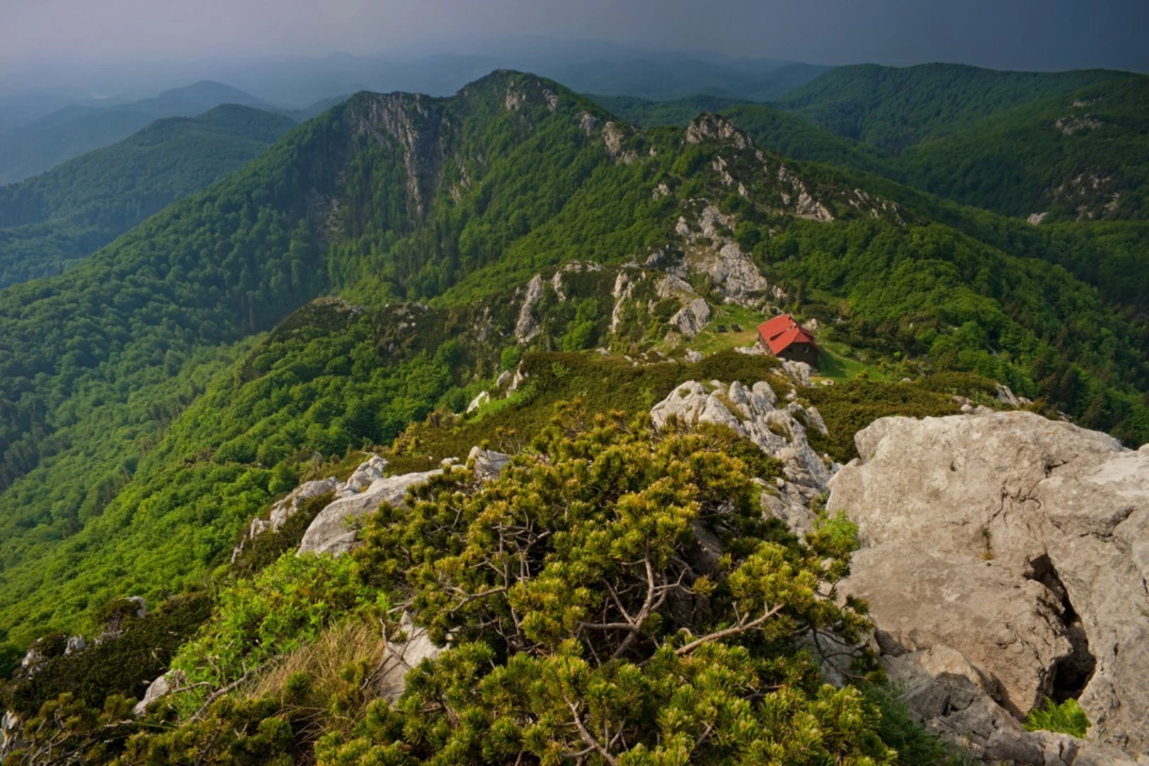
Landmarks and Natural Features The Snježnik Mountain Trail is known for its breathtaking vistas and the variety of landscapes it traverses. In the initial phase of the hike, you'll pass through dense forests, home to a rich array of flora and fauna. Keep an eye out for local wildlife, including deer and a variety of bird species.
As you ascend, the forest canopy opens up to reveal stunning views of the surrounding mountains and valleys. The trail leads you through alpine meadows dotted with wildflowers, especially vibrant in the spring and summer months.
Historical Significance The region is steeped in history, with the mountain itself having been a strategic lookout point over the centuries. Hikers will find remnants of past military significance, including old bunkers and border stones that date back to times when the area was a contested territory.
Preparing for the Hike Given the length and elevation gain of the Snježnik Mountain Trail, it's important to prepare adequately. Ensure you have enough water, as there are limited sources along the route, and pack high-energy snacks and food for the journey. Weather conditions can change rapidly in the mountains, so layered clothing and waterproof gear are essential.
Safety and Conservation Always stay on marked trails to preserve the delicate ecosystems and to ensure your safety. Be mindful of the weather forecasts and start your hike early in the day to avoid being caught on the trail after dark. It's also crucial to leave no trace, taking all your rubbish with you and respecting the natural habitat.
By following these guidelines and preparing properly, hikers can look forward to an unforgettable experience on the Snježnik Mountain Trail, surrounded by the natural beauty and historical intrigue of this captivating region.

Frequently asked questions
How long does the Snježnik Mountain Trail take to hike?
The Snježnik Mountain Trail is 38.11 km long and is typically done as a 2-day multi-day hike. HiiKER’s stage breakdown shows one stage of about 17.5 km and a second of about 20.6 km, which fits an overnight itinerary rather than a single short day hike.
How difficult is the Snježnik Mountain Trail in Croatia?
The Snježnik Mountain Trail is rated Extra Difficult, with 1,471 m of total elevation gain over 38.11 km. That combination of distance and climbing makes it a demanding route best suited to experienced hikers comfortable with long mountain days and sustained ascents.
Where can you start the Snježnik Mountain Trail?
A mapped start point for the Snježnik Mountain Trail is at Dom Snježnik in Primorje-Gorski Kotar County. HiiKER’s stage information also shows the route finishing near Dražice centar, so the trail works as a point-to-point hike rather than a simple out-and-back.
Is there parking for the Snježnik Mountain Trail?
Parking is available near the entrance to the Snježnik Mountain Trail trailhead area. One of the mapped access points is around Dom Snježnik, so most hikers arriving by car use local mountain roads to reach the start before continuing on foot.
Do I need a map for the Snježnik Mountain Trail?
A map is strongly recommended for the Snježnik Mountain Trail because it is a 38.11 km multi-day route with 1,471 m of ascent. The trail is marked, but a detailed digital map is useful for following the main line, checking stage distances, and staying on route where mountain paths become less distinct.
What are the main landmarks on the Snježnik Mountain Trail?
The route is associated with Dom Snježnik at the start and finishes near Dražice centar, crossing mountain terrain in Primorje-Gorski Kotar County. The wider Snježnik area is known for broad summit views, and nearby park information identifies Snježnik’s summit at 1,506 m with views over the surrounding ridges and toward the sea on clear days.
Comments and Reviews
User comments, reviews and discussions about the Snježnik Mountain Trail, Croatia.
5.0
average rating out of 5
3 rating(s)