Download
3D Flyover
Add to list
More
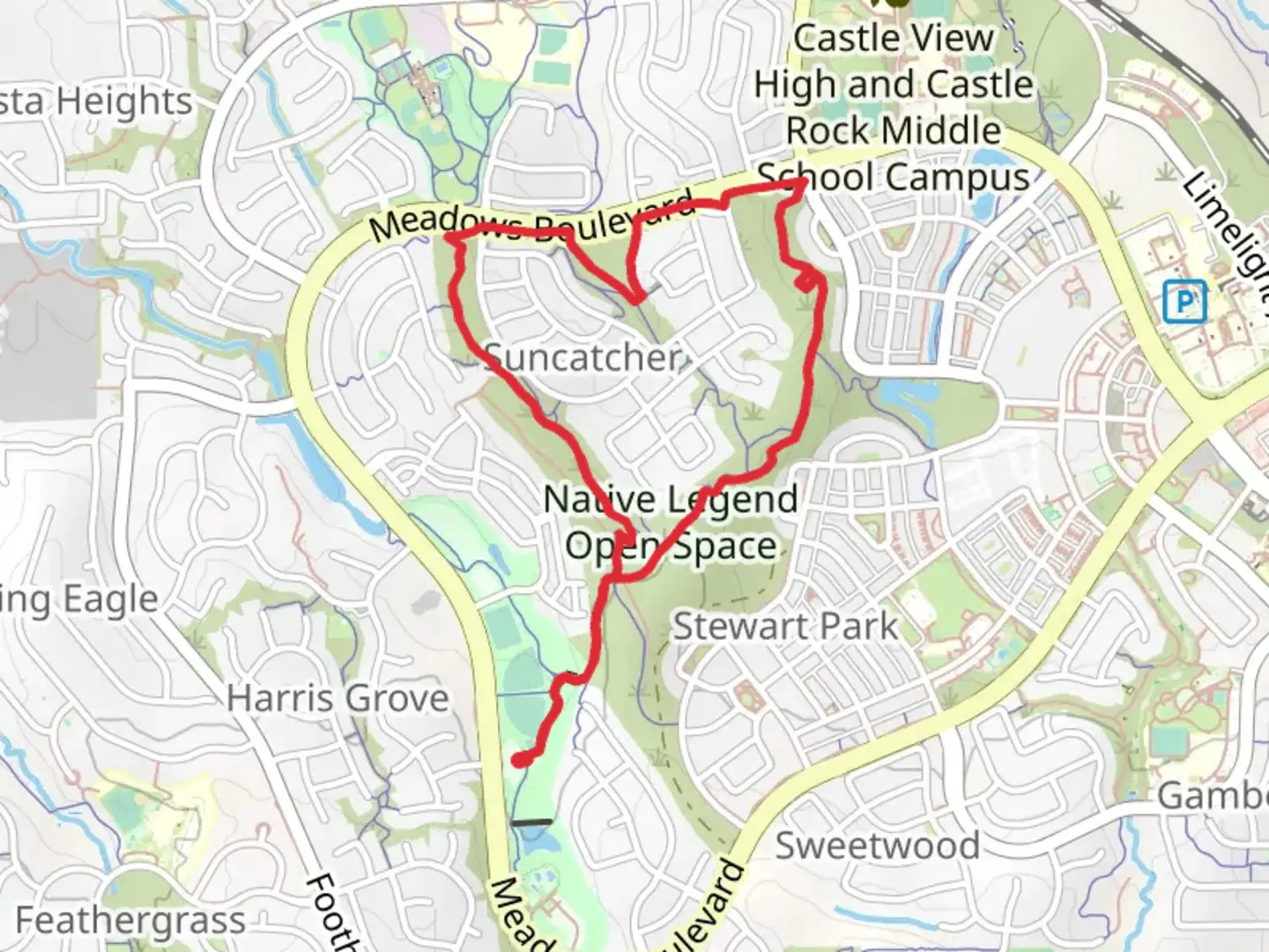
4.8 km
~1 hrs 7 min
101 m
Loop
“Embark on the Native Legend Loop Trail for a scenic 5 km hike rich in nature and history.”
Starting your adventure near Douglas County, Colorado, the Native Legend Loop Trail offers a captivating 5 km (approximately 3.1 miles) journey with an elevation gain of around 100 meters (328 feet). This loop trail is rated as medium difficulty, making it accessible for most hikers with a moderate level of fitness.
Getting There
To reach the trailhead, you can drive or use public transportation. If driving, head towards the nearest significant landmark, the Castle Rock Outlet Mall. From there, it's a short drive to the trailhead. For those using public transport, take a bus to the Castle Rock Station and then a taxi or rideshare service to the trailhead.
Trail Overview
The trailhead is well-marked and offers ample parking. As you begin your hike, you'll notice the terrain is a mix of dirt paths and rocky sections. The initial part of the trail is relatively flat, allowing you to ease into the hike.
Flora and Fauna
The trail is rich in native flora, including ponderosa pines, scrub oak, and wildflowers during the spring and summer months. Keep an eye out for local wildlife such as mule deer, foxes, and a variety of bird species. The area is also known for its vibrant butterfly population, especially near the meadows.
Significant Landmarks
At approximately 1.5 km (0.9 miles) into the hike, you'll come across a large rock formation known locally as "Eagle's Perch." This is a great spot for a short break and some photos. The rock formation offers a panoramic view of the surrounding landscape, including distant mountain ranges.
Historical Significance
The region holds historical significance as it was once inhabited by Native American tribes, including the Ute and Arapaho. Along the trail, you'll find informational plaques detailing the history and legends of these tribes. These plaques provide a fascinating glimpse into the cultural heritage of the area.
Midpoint and Elevation Gain
Around the 2.5 km (1.55 miles) mark, you'll reach the highest point of the trail, with an elevation gain of about 100 meters (328 feet). This section offers a bit of a challenge with its steeper incline, but the effort is rewarded with stunning views of the valley below.
Navigation
For navigation, it's highly recommended to use the HiiKER app, which provides detailed maps and real-time updates. The trail is well-marked, but having a reliable navigation tool can enhance your hiking experience and ensure you stay on track.
Final Stretch
As you descend from the highest point, the trail loops back towards the starting point. This section is mostly downhill, making for a pleasant and leisurely end to your hike. The final kilometer (0.62 miles) takes you through a shaded forest area, offering a cool and serene environment.
Practical Tips
- Bring plenty of water, especially during the summer months.
- Wear sturdy hiking boots to navigate the rocky sections.
- Check the weather forecast before heading out, as the trail can become slippery after rain.
- Be mindful of local wildlife and maintain a safe distance.
This trail offers a perfect blend of natural beauty, moderate challenge, and historical intrigue, making it a must-visit for any hiking enthusiast.

What to expect?
Activity types
Comments and Reviews
User comments, reviews and discussions about the Native Legend Loop Trail, Colorado.
4.71
average rating out of 5
7 rating(s)