Download
3D Flyover
Add to list
More
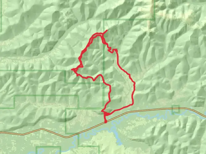
24.0 km
~5 hrs 55 min
669 m
Multi-Day
“Embark on Stiles Creek Trail's challenging 24-km Alaskan trek, brimming with wildlife, history, and breathtaking vistas.”
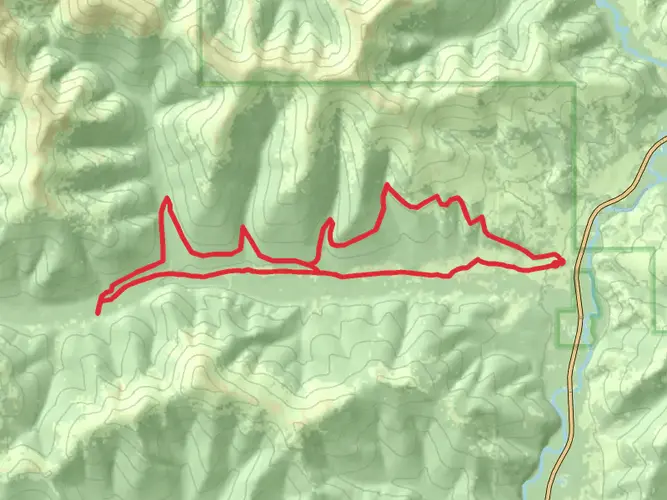
Stiles Creek Trail, nestled near Fairbanks North Star in Alaska, offers an invigorating point-to-point hike that spans approximately 24 kilometers (about 15 miles) with an elevation gain of around 600 meters (roughly 2000 feet). This trail is considered difficult due to its length and the elevation profile, so it's essential for hikers to be well-prepared before embarking on this journey.
Getting to the Trailhead
To reach the trailhead, hikers can drive to the Chena Hot Springs Road area, which is accessible from Fairbanks. There is no direct public transportation to the trailhead, so a personal vehicle or a taxi service is necessary. Upon arriving at the Chena Hot Springs Road, follow the signs leading to the Stiles Creek Trail parking area, where you can safely leave your car before starting the hike.
Navigating the Trail
Hikers should download the trail map onto their HiiKER app before setting out, as cell service can be unreliable in this remote area. The trail begins with a gradual incline through dense boreal forests, home to a variety of wildlife including moose, bears, and numerous bird species. It's crucial to be bear-aware, carry bear spray, and make noise while hiking to avoid surprising any wildlife.
Landmarks and Scenery
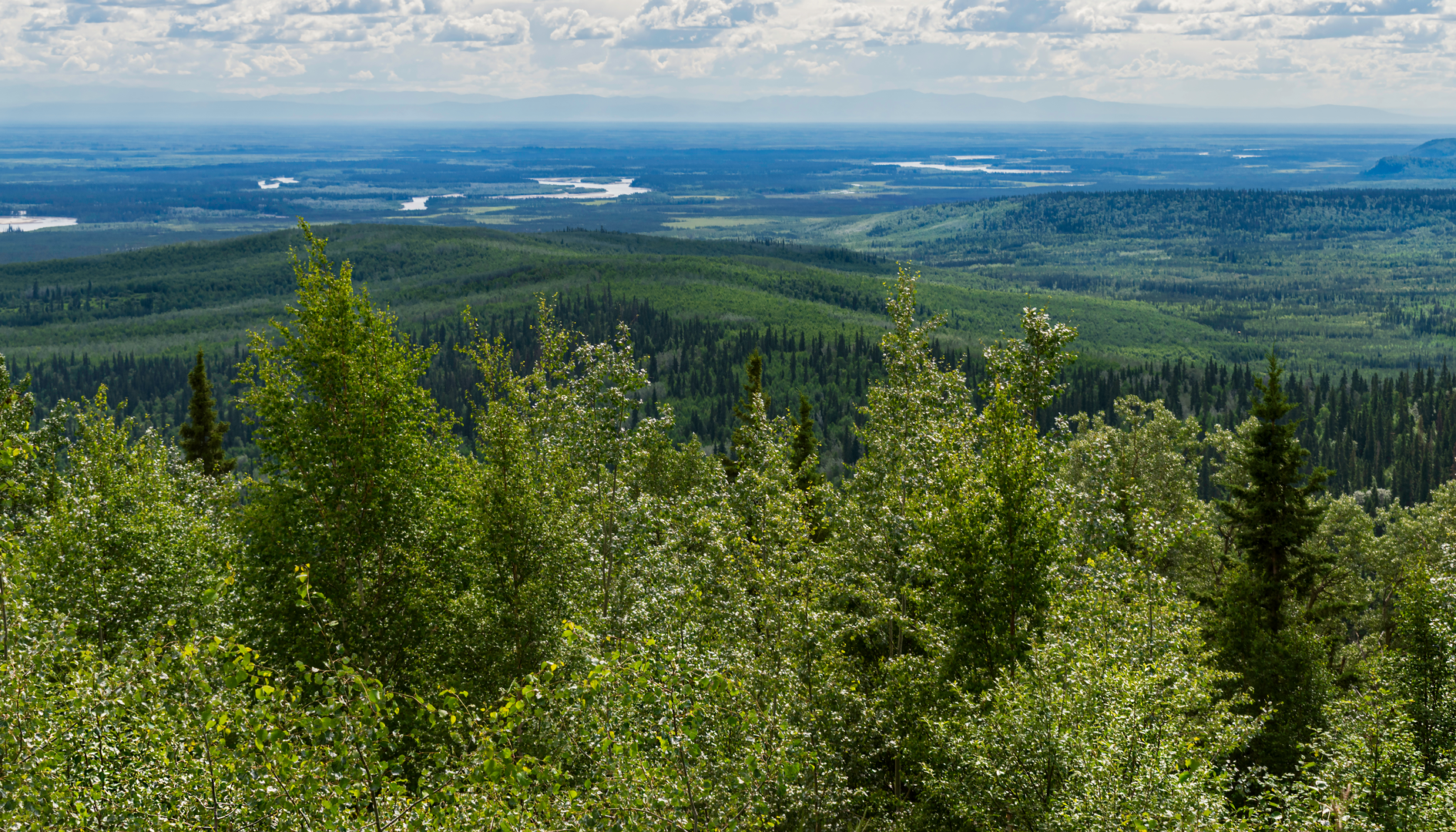
As you progress along the trail, you'll encounter several creek crossings that may require careful navigation, especially during the spring thaw or after heavy rainfall. The trail offers stunning views of the surrounding hills and valleys, with opportunities to see the Alaska Range on clear days.
Around the halfway mark, hikers will find themselves at the highest elevation point, which provides a panoramic vista of the White Mountains and the Chena River State Recreation Area. This is a great spot to rest and take in the scenery before continuing on the descent.
Historical Significance
The region around Stiles Creek Trail is rich in history, with the Chena River being a vital resource for the indigenous peoples and later for gold miners during the Alaskan gold rush. As you hike, you may come across remnants of old mining operations, adding a historical dimension to your trek.
Flora and Fauna
Throughout the hike, the trail weaves through a tapestry of spruce, birch, and aspen trees. During the fall, the foliage transforms into a vibrant display of yellows and reds, making it an especially picturesque time to hike. The area is also known for its wildflowers, including fireweed and lupine, which bloom in the summer months.
Preparation and Safety
Given the trail's difficulty, hikers should be in good physical condition and carry the necessary gear, including adequate food, water, and layers to adapt to the unpredictable Alaskan weather. It's also wise to inform someone of your hiking plans and expected return time.
Remember, the Stiles Creek Trail is a backcountry experience, and as such, hikers should practice Leave No Trace principles to preserve the natural beauty and minimize their impact on the environment.

Activity types
Frequently asked questions
How long does it take to hike Stiles Creek Trail near Fairbanks?
Stiles Creek Trail is 24.02 km, or about 15 miles, with 669 m of elevation gain, so it is usually treated as a full-day outing or an overnight point-to-point hike. Strong hikers may finish it in a long day, but the distance, climbing, and creek crossings make it more demanding than a short Fairbanks-area day hike.
Where is the trailhead for Stiles Creek Trail and where can you park?
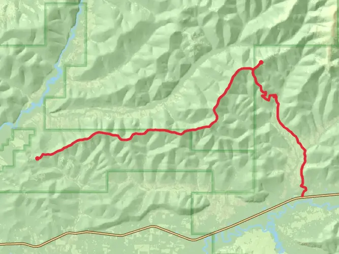
Stiles Creek Trail begins in Chena River State Recreation Area off Chena Hot Springs Road east of Fairbanks. Alaska State Parks maps place one Stiles Creek trailhead at mile 31.6 on Chena Hot Springs Road, and the route also connects toward the mile 36.4 shooting range area, so parking logistics matter because it is a point-to-point trail.
Is Stiles Creek Trail a loop or a point-to-point hike?
Stiles Creek Trail is a point-to-point route, not a loop. The full hike covers 24.02 km between trail access points in the Chena Hot Springs Road corridor, so many hikers arrange a shuttle or leave a second vehicle rather than planning to retrace the entire route.
Are there creek crossings on Stiles Creek Trail?
Yes. Stiles Creek Trail includes several creek crossings, and they can become the crux of the hike during spring snowmelt or after heavy rain. Water levels in Interior Alaska can change quickly, so crossings that feel straightforward in dry conditions may be slower and more serious earlier in the season.
Is Stiles Creek Trail hard?
Stiles Creek Trail is rated medium, but the numbers make it a substantial outing: 24.02 km with 669 m of climbing. The length, remote setting, and crossing conditions can push it beyond a typical moderate walk, especially for hikers who are not used to long point-to-point routes in Alaska.
Can you see wildlife on Stiles Creek Trail?
Wildlife is part of the experience on Stiles Creek Trail and along the Chena Hot Springs Road corridor. The area east of Fairbanks is well known for moose viewing, and hikers should also be prepared for bear country, especially in forested sections and near creeks where visibility can be limited.
Is Stiles Creek Trail dog-friendly?
Dogs are generally allowed in Alaska State Parks settings, and the nearby Stiles Creek Cabin rules specifically allow pets, which indicates dogs are permitted in this trail corridor. Even so, Stiles Creek Trail is a serious route for dogs because of the 24.02 km distance, uneven footing, wildlife, and creek crossings.
Comments and Reviews
User comments, reviews and discussions about the Stiles Creek Trail, Alaska.
4.36
average rating out of 5
22 rating(s)