Left Fork Maple Canyon Trail
12.8 km
~3 hrs 51 min
777 m
“Embark on the exhilarating Left Fork Maple Canyon Trail for stunning views, diverse wildlife, and historical wonders.”
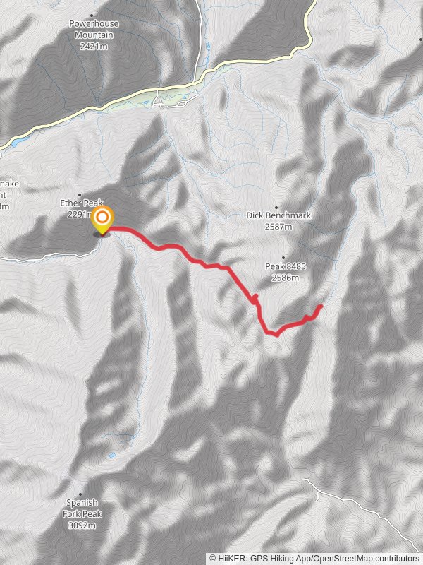
Starting your adventure near Utah County, Utah, the Left Fork Maple Canyon Trail is an invigorating out-and-back hike that spans approximately 13 kilometers (8 miles) with an elevation gain of around 700 meters (2,300 feet). This trail is rated as medium difficulty, making it suitable for moderately experienced hikers looking for a rewarding challenge.
### Getting There To reach the trailhead, you can drive or use public transportation. If driving, head towards the nearest significant landmark, which is the town of Mapleton, Utah. From Mapleton, follow the signs to the Left Fork Maple Canyon Trailhead. For those using public transport, the nearest bus stop is in Mapleton, from where you can take a local taxi or rideshare service to the trailhead.
### Trail Overview The trail begins with a gentle ascent through a lush forest of maple and oak trees, providing ample shade and a serene atmosphere. As you progress, the path becomes steeper, offering panoramic views of the surrounding canyon and distant mountain ranges. The first significant landmark you'll encounter is a small, picturesque waterfall about 3 kilometers (1.9 miles) into the hike. This is a great spot to take a break and enjoy the natural beauty.
### Flora and Fauna The trail is rich in biodiversity. Keep an eye out for mule deer, wild turkeys, and a variety of bird species. The flora changes with elevation; lower sections are dominated by maple and oak, while higher elevations feature conifers and alpine meadows. During spring and early summer, the trail is adorned with wildflowers, adding vibrant colors to your journey.
### Historical Significance The region has a rich history, with evidence of Native American habitation dating back thousands of years. The Ute tribe, in particular, has historical ties to this area. As you hike, you may notice ancient petroglyphs on some of the rock faces, offering a glimpse into the past.
### Navigation and Safety Given the trail's moderate difficulty, it's advisable to use a reliable navigation tool like HiiKER to keep track of your progress and ensure you stay on the correct path. The trail is well-marked, but having a digital map can be invaluable, especially in areas where the path may be less distinct.
### Elevation and Terrain The elevation gain of 700 meters (2,300 feet) is spread out over the 13 kilometers (8 miles), with some sections being steeper than others. The terrain varies from packed dirt to rocky outcrops, so sturdy hiking boots are recommended. Trekking poles can also be helpful, particularly on the steeper sections.
### Points of Interest Around the 6.5-kilometer (4-mile) mark, you'll reach the highest point of the trail, offering breathtaking views of the canyon below and the Wasatch Range in the distance. This is an excellent spot for photos and a well-deserved rest before you begin your descent.
### Return Journey The return journey follows the same path, allowing you to enjoy the scenery from a different perspective. Be mindful of your footing, especially on the descent, as the rocky sections can be slippery.
### Final Tips Carry plenty of water, as there are no reliable water sources along the trail. Snacks and a packed lunch will keep your energy levels up. Weather can change rapidly in this region, so bring layers and be prepared for sudden shifts in temperature.
By following these guidelines and being well-prepared, you'll have a memorable and enjoyable hike on the Left Fork Maple Canyon Trail.
Reviews
User comments, reviews and discussions about the Left Fork Maple Canyon Trail, Utah.
4.0
average rating out of 5
15 rating(s)


