11.4 km
~3 hrs 28 min
718 m
“The 11 km Mattenhoefle Schirmkopf and Ibacher Schliff Loop offers lush forests, historical landmarks, and panoramic views.”
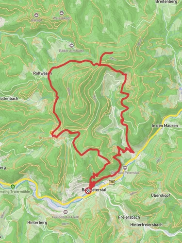
Starting near Ortenaukreis, Germany, the Mattenhoefle Schirmkopf and Ibacher Schliff Loop is a captivating 11 km (approximately 6.8 miles) trail with an elevation gain of around 700 meters (2,297 feet). This loop trail is rated as medium difficulty, making it suitable for moderately experienced hikers.
### Getting There To reach the trailhead, you can drive or use public transport. If driving, set your GPS to the nearest known address: Ortenaukreis, Germany. For those using public transport, take a train to the nearest major station in Offenburg, and from there, you can catch a local bus to Ortenaukreis. The trailhead is conveniently located near the town, making it accessible for day trips.
### Trail Overview The trail begins with a gentle ascent through dense forest, offering a serene start to your hike. As you progress, the path becomes steeper, leading you to the first significant landmark, Mattenhoefle. This area is known for its lush greenery and diverse flora, including various species of ferns and wildflowers.
### Key Landmarks and Elevation At around the 3 km (1.86 miles) mark, you'll reach Schirmkopf, a notable peak offering panoramic views of the surrounding Black Forest region. The elevation gain here is approximately 300 meters (984 feet), providing a rewarding challenge for hikers. Take a moment to enjoy the vistas and perhaps snap a few photos.
Continuing on, the trail descends slightly before climbing again towards Ibacher Schliff. This section is particularly scenic, with rocky outcrops and clearings that offer glimpses of local wildlife such as deer and various bird species. The elevation gain in this segment is around 200 meters (656 feet), making it a bit easier than the initial climb.
### Historical Significance The region around Ortenaukreis has a rich history dating back to Roman times. As you hike, you'll come across several historical markers and ruins, including remnants of old watchtowers used during medieval times. These landmarks provide a fascinating glimpse into the area's past and are well worth a brief stop.
### Navigation and Safety Given the trail's moderate difficulty, it's advisable to use a reliable navigation tool like HiiKER to stay on track. The trail is well-marked, but having a digital map can be incredibly helpful, especially in the denser forest sections where visibility might be limited.
### Flora and Fauna The Black Forest is renowned for its biodiversity. Along the trail, you'll encounter a variety of plant species, from towering pines to delicate wildflowers. Keep an eye out for local wildlife, including foxes, badgers, and a variety of bird species. The forest is also home to several types of mushrooms, but be cautious and avoid picking them unless you're certain they are safe to consume.
### Final Stretch The last few kilometers of the trail are a gentle descent back towards the trailhead. This section is less strenuous, allowing you to relax and enjoy the final moments of your hike. The path winds through open meadows and small streams, providing a peaceful end to your journey.
### Practical Tips - Wear sturdy hiking boots, as the trail can be rocky and uneven in places. - Bring plenty of water and snacks, especially during warmer months. - Check the weather forecast before heading out, as conditions can change rapidly in the Black Forest. - Consider starting early in the day to avoid the midday heat and to give yourself plenty of time to complete the loop.
This trail offers a perfect blend of natural beauty, historical intrigue, and moderate physical challenge, making it a must-visit for any hiking enthusiast exploring the Black Forest region.
Reviews
User comments, reviews and discussions about the Mattenhoefle Schirmkopf and Ibacher Schliff Loop, Germany.
0.0
average rating out of 5
0 rating(s)


