Download
3D Flyover
Add to list
More
66.5 km
~3 days
659 m
Multi-Day
“Embark on a 41-mile journey through history and nature's splendor along Pennsylvania's Redbank Valley Trail.”
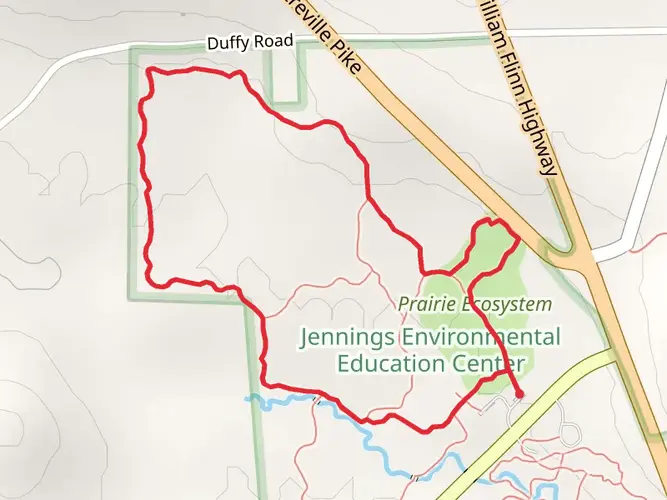
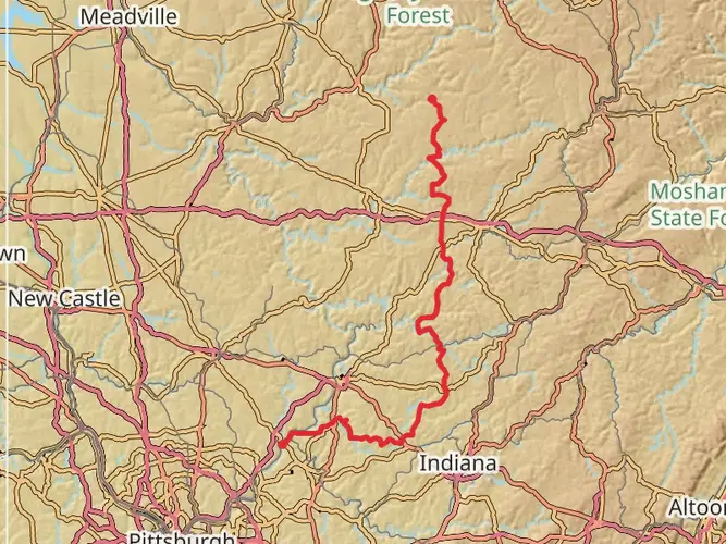
The Redbank Valley Trail stretches approximately 41 miles (66 kilometers) and offers a moderate challenge with an elevation gain of around 1,968 feet (600 meters). This point-to-point trail is nestled in the scenic landscapes of Clarion County, Pennsylvania, and is accessible from the trailhead located near the town of Brookville.
Getting to the Trailhead
To reach the starting point of the Redbank Valley Trail, hikers can drive to the western terminus near Brookville, PA. If you're coming from Pittsburgh, take I-79 N and then merge onto I-80 E, following signs for Clarion. Exit at PA-28 N, which will lead you directly to Brookville. For those relying on public transportation, options are limited, but regional bus services may offer routes close to the area, from where a taxi or ride-share can complete the journey.
Trail Experience
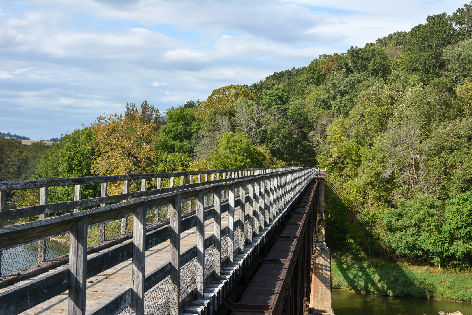
As you embark on the Redbank Valley Trail, you'll be greeted by a diverse landscape that includes lush forests, meandering streams, and the picturesque Redbank Creek. The trail, primarily crushed limestone, is well-maintained and suitable for both hikers and cyclists. It's important to note that the trail also accommodates horseback riding in certain sections.
Historical Significance and Landmarks
The Redbank Valley Trail has a rich history, following a former railroad corridor. As you hike, you'll encounter remnants of this past, including old train stations and railroad bridges. Notably, the Climax Tunnel and several other smaller tunnels along the route offer a glimpse into the engineering feats of the late 19th and early 20th centuries.
Flora and Fauna
Nature enthusiasts will appreciate the diverse ecosystems along the trail. The area is home to a variety of wildlife, including white-tailed deer, beavers, and numerous bird species. The changing seasons bring about a kaleidoscope of colors, with vibrant wildflowers in the spring and a spectacular display of fall foliage.
Navigation and Preparation
For navigation, HiiKER is an excellent tool to use while traversing the Redbank Valley Trail. It's advisable to download the trail map on your device before setting out, as cell service can be spotty in remote areas. Hikers should prepare for the trail by packing adequate water, snacks, and wearing suitable footwear for the terrain. It's also wise to check the weather forecast and dress in layers to accommodate changing conditions.
Trail Etiquette and Safety
Remember to practice Leave No Trace principles to preserve the beauty of the trail for future visitors. Stay on marked paths, dispose of waste properly, and be considerate of other trail users. Safety is paramount, so let someone know your plans before you head out and be aware of your surroundings, especially when encountering wildlife or navigating through tunnels.
By following these guidelines and being prepared, hikers can fully enjoy the natural beauty and historical significance of the Redbank Valley Trail.

What to expect?
Activity types
Frequently asked questions
How long is the Redbank Valley Trail and how many days does it take to finish?
The Redbank Valley Trail is 66.49 km, or about 41.3 miles, with roughly 659 m of climbing. Strong walkers can cover it in a long single day on the rail-trail grade, but many split it into 2 to 3 days, especially if stopping in trail towns such as New Bethlehem or riding the Sligo spur.
What is the surface like on the Redbank Valley Trail in Pennsylvania?
Most of the Redbank Valley Trail has a crushed limestone surface on a former railroad corridor, which keeps grades gentle and footing generally straightforward. One standout feature is the paved Climax Tunnel area at about mile 17, but wet or frosty conditions can make bridges and the tunnel slick.
Where can you park for the Redbank Valley Trail near Brookville or New Bethlehem?
Parking is available at multiple access points on the Redbank Valley Trail, including Brookville, New Bethlehem, the Climax Tunnel west portal area, and other trailheads along the corridor. New Bethlehem has downtown trail access, while Brookville serves as an eastern end access point near mile 41 of the main line.
Is the Climax Tunnel on the Redbank Valley Trail open?
The Climax Tunnel on the Redbank Valley Trail is currently open, and it is one of the route’s best-known landmarks. It sits around mile post 17, and the trail association notes that the tunnel and bridges can be slippery when wet or during frosty weather, so traction and lighting matter there.
Is the Redbank Valley Trail good for beginners and families?
Yes. The Redbank Valley Trail is generally considered easy because it follows a rail-trail corridor with modest overall elevation gain for its 66.49 km length. The broad crushed-limestone tread and access through communities such as New Bethlehem also make shorter out-and-back family walks practical.
Can you bike or ride horses on the Redbank Valley Trail?
The Redbank Valley Trail is a non-motorized four-season trail used by hikers and cyclists, and horseback riding is also allowed on parts of the corridor. Its former railroad alignment keeps the grade mild, which is one reason it is popular for longer bike trips as well as walking sections between trailheads.
Where does the Redbank Valley Trail start and end?
The main Redbank Valley Trail runs between the Armstrong Trail connection near the Allegheny River and Brookville, with New Bethlehem near the midpoint. In addition to the main line, there is also a roughly 9-mile Sligo spur branching north from Lawsonham, bringing the wider trail system to about 51 miles.
Comments and Reviews
User comments, reviews and discussions about the Redbank Valley Trail, Pennsylvania.
4.82
average rating out of 5
11 rating(s)