Download
3D Flyover
Add to list
More
57.4 km
~3 days
2135 m
Multi-Day
The Taconic Crest Trail is a challenging and rewarding point-to-point hike that spans approximately 57 kilometers (35 miles) along the Taconic Mountain Range. With an elevation gain of around 2,100 meters (6,890 feet), this trail traverses through the states of New York, Massachusetts, and Vermont, offering a diverse hiking experience characterized by scenic vistas, lush forests, and a variety of wildlife.
Getting to the Trailhead
The southern terminus of the Taconic Crest Trail is located near Rensselaer County, New York. For those driving, the trailhead can be accessed by taking NY Route 346 to North Petersburg, NY, and then following signs to Petersburg Pass, which is near the border of New York and Massachusetts. There is a parking area on Route 2, which serves as a good starting point for the hike.
Public transportation options are limited, but hikers can reach the general vicinity of the trailhead by taking a bus to nearby towns and then arranging for a taxi or rideshare to the trailhead.
Trail Experience
As you embark on the Taconic Crest Trail, you'll be greeted by a mix of hardwood forests and conifer stands, with the trail meandering through a variety of terrains. The first section of the trail includes a steady climb, which will take you to a series of ridgelines offering expansive views of the surrounding valleys and peaks.
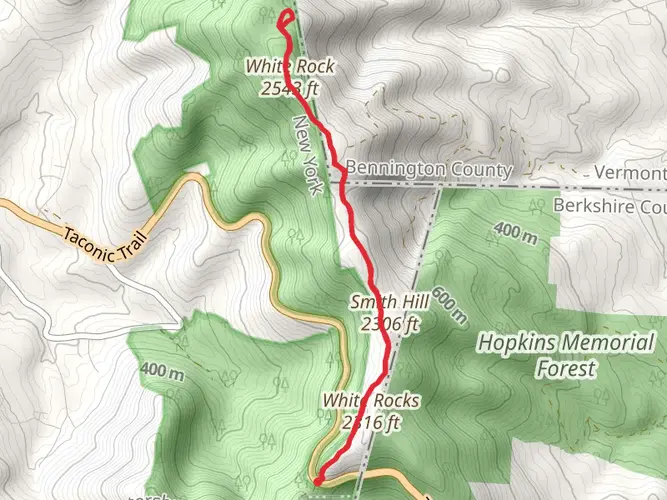
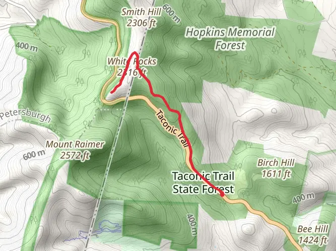
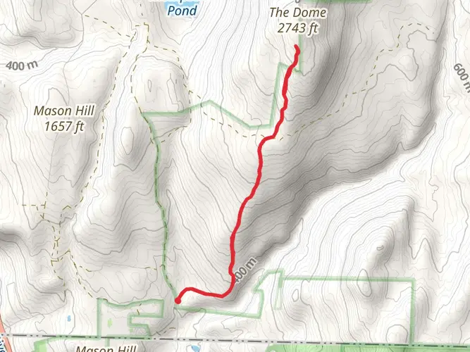
One of the highlights of the trail is the 3.2-kilometer (2-mile) stretch known as the Snow Hole, a deep crevice where snow is often found even in the warmer months. This natural feature is located approximately 16 kilometers (10 miles) from the southern trailhead.
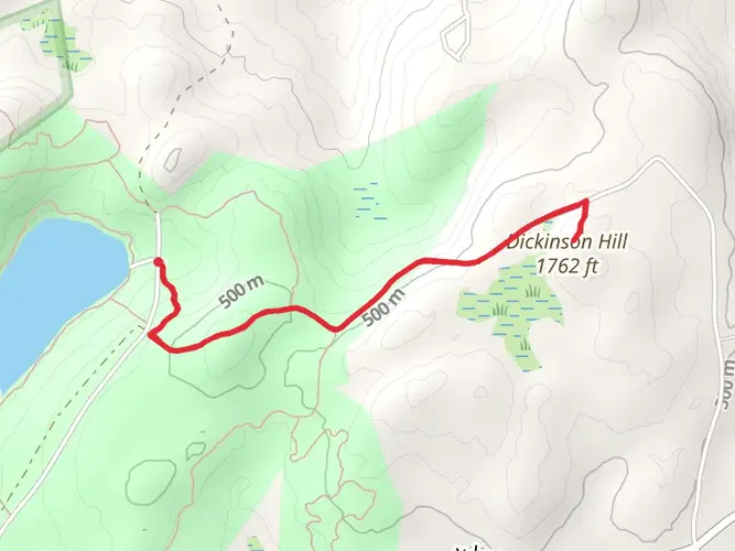
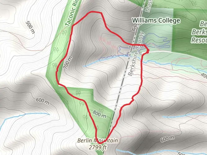
Further along, hikers will encounter the Berlin Mountain, the highest point in Rensselaer County at 855 meters (2,807 feet). This area provides stunning panoramic views and is a perfect spot for a rest and photo opportunity.
Wildlife is abundant throughout the Taconic Crest Trail, with chances to see deer, black bears, and a variety of bird species. Hikers should be prepared for possible encounters and know how to safely observe wildlife from a distance.
Historical Significance
The Taconic Range is steeped in history, with the trail passing through areas that were once significant for Native American tribes, early settlers, and during the Revolutionary War. The trail itself is a testament to the conservation efforts in the region, preserving this natural corridor for future generations to enjoy.
Navigation and Preparation
Given the trail's length and difficulty, it is essential to be well-prepared with adequate supplies, including water, food, and layers for changing weather conditions. Hikers should also have a map and compass or a GPS device. For digital navigation, the HiiKER app can be a valuable tool for accessing trail maps and waypoints.
Trail Etiquette and Conservation
As with any outdoor activity, it is crucial to practice Leave No Trace principles to minimize your impact on the environment. Stay on marked trails, pack out all trash, and be considerate of other hikers and wildlife.
The Taconic Crest Trail offers a challenging yet immensely rewarding experience for seasoned hikers. With its rich history, diverse ecosystems, and stunning views, it is a hike that promises adventure and a deep connection with the natural world.

What to expect?
Activity types
Frequently asked questions
How long is the Taconic Crest Trail and how hard is the full hike?
The Taconic Crest Trail is about 57.38 km, or roughly 35.7 miles, with 2,135 meters of climbing. That combination makes it a difficult multi-day point-to-point route rather than a casual day hike, especially because the trail stays on a ridgeline with repeated ascents and descents across New York, Massachusetts, and Vermont.
Where do you park for the Taconic Crest Trail at Petersburg Pass?
One of the best-known access points for the Taconic Crest Trail is the Petersburg Pass parking area on Route 2 near the New York–Massachusetts line. New York DEC lists the lot at about 42.742876, -73.282566, and this trailhead is commonly used for the Snow Hole section as well as longer hikes north or south along the crest.
What is the Snow Hole on the Taconic Crest Trail and how far is it from Petersburg Pass?
The Snow Hole is a deep crevice off the Taconic Crest Trail near Petersburg Pass where snow can linger well into early summer. New York DEC describes the popular out-and-back from Petersburg Pass as about 6 miles round trip, following the white-and-blue-marked trail to the White Rocks area and then a short side trail to the Snow Hole.
What are the main highlights on the Taconic Crest Trail?
Major highlights on the Taconic Crest Trail include Berlin Mountain, the highest point on the route at nearly 3,000 feet, and the Snow Hole near Petersburg Pass. Farther south, the trail also reaches the Berry Pond area in Pittsfield State Forest, a well-known landmark on the Taconic ridge.
Does the Taconic Crest Trail cross more than one state?
Yes. The Taconic Crest Trail runs along the Taconic Range and crosses back and forth through New York, Massachusetts, and Vermont. That interstate ridgeline character is one of the route’s defining features, and it is part of what makes the full hike feel like a true end-to-end traverse rather than a single-park trail.
How much elevation gain is on the Taconic Crest Trail?
The Taconic Crest Trail gains about 2,135 meters, which is roughly 7,005 feet of ascent over the full route. Even though the highest terrain is only around Berlin Mountain’s 3,000-foot elevation, the repeated climbs and drops along the crest add up quickly and are a big reason the trail is rated difficult.
Can the Taconic Crest Trail be done as a shorter day hike instead of a thru-hike?
Yes. While the full Taconic Crest Trail is a difficult multi-day hike, Petersburg Pass is a popular place to break it into a shorter outing. The Snow Hole section from the Route 2 parking area is a well-known day hike, and Berlin Mountain is another commonly targeted segment for hikers who want a shorter but still strenuous ridge walk.
Comments and Reviews
User comments, reviews and discussions about the Taconic Crest Trail, New York.
4.4
average rating out of 5
5 rating(s)