Download
3D Preview
Add to list
More
270.4 km
~11 days
5254 m
Multi-Day
The Highlands Trail is a remarkable journey through the scenic landscapes of the northeastern United States, stretching approximately 270 kilometers (about 168 miles) with an elevation gain of around 5200 meters (approximately 17,060 feet). This point-to-point trail begins near Orange County, New York, and offers a medium difficulty rating, making it accessible to hikers with a moderate level of experience.
Getting to the Trailhead
The starting point of the Highlands Trail is accessible by both public transportation and car. For those opting for public transit, the nearest significant landmark is the Port Authority Bus Terminal in New York City, where you can catch a bus to the vicinity of the trailhead. If traveling by car, the trailhead is located near the intersection of State Route 17 and County Route 106, close to the village of Harriman, New York.
Navigating the Trail
To navigate the trail, hikers are encouraged to use the HiiKER app, which provides detailed maps and GPS coordinates to ensure you stay on the correct path. The trail is well-marked with blazes, but having a digital tool like HiiKER can be invaluable for planning and staying on track.
Trail Highlights and Landmarks
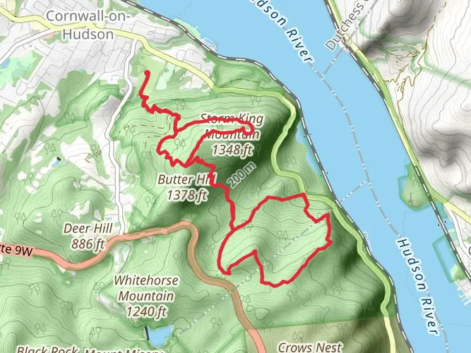
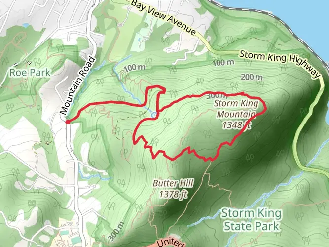
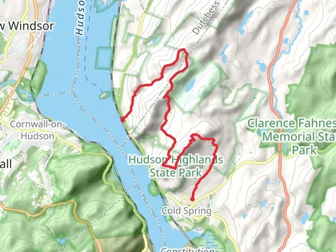
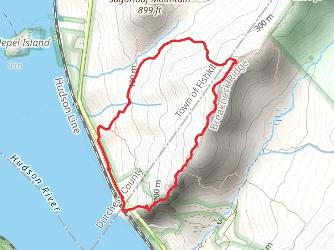
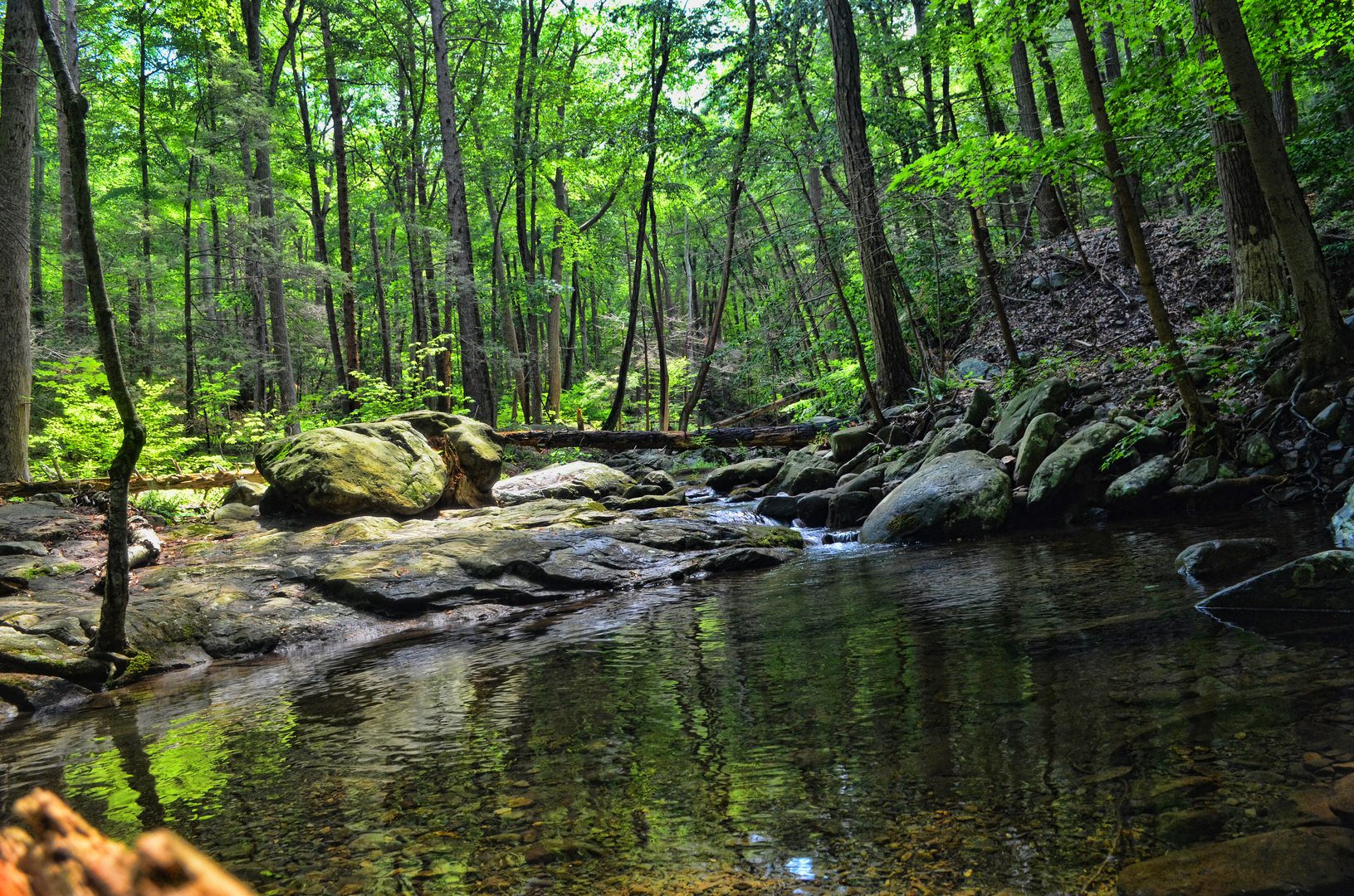
As you embark on the Highlands Trail, you'll traverse a variety of terrains, including dense forests, rolling hills, and rocky outcrops. The trail offers stunning views of the Hudson River and the New York City skyline on clear days. Approximately 40 kilometers (25 miles) into the hike, you'll encounter the Bear Mountain State Park, which is home to Bear Mountain, a notable peak with an elevation of 390 meters (1,280 feet).
Continuing on, the trail passes through Sterling Forest State Park, a significant expanse of nearly untouched natural beauty. Here, hikers can enjoy the sights and sounds of wetlands, streams, and dense hardwood forests. Wildlife is abundant, with the possibility of spotting deer, black bears, and a variety of bird species.
Historically, the region played a crucial role during the Revolutionary War, with several landmarks along the trail, including Fort Montgomery and the West Point Military Academy. These sites offer a glimpse into the past and are a testament to the area's strategic importance.
Preparation and Safety
Before setting out, hikers should be well-prepared with appropriate gear, including sturdy hiking boots, weather-appropriate clothing, and sufficient water and food supplies. The trail includes some steep sections, so trekking poles may be beneficial for additional support.
Given the trail's length, many hikers choose to tackle it in sections. There are several access points along the route, allowing for shorter day hikes or weekend trips. It's important to plan your itinerary carefully, taking into account your pace and the time of year, as daylight hours will vary.
Weather and Seasonal Considerations
The Highlands Trail can be hiked year-round, but the best conditions are typically found in the spring and fall when temperatures are mild, and the foliage is particularly striking. Summer brings warmer weather but also more crowds and the potential for thunderstorms. Winter hiking is possible, but snow and ice can make the trail more challenging and require additional gear such as microspikes or snowshoes.
Leave No Trace
As with any outdoor activity, it's crucial to follow Leave No Trace principles to minimize your impact on the environment. This includes packing out all trash, staying on designated trails to prevent erosion, and being respectful of wildlife and other hikers.
By preparing adequately and respecting the natural and historical significance of the Highlands Trail, hikers can enjoy a rewarding and memorable experience traversing this diverse and beautiful region.

What to expect?
Activity types
Frequently asked questions
How long is the Highlands Trail in Orange County, New York?
The Highlands Trail is about 270.38 kilometers long, or roughly 168 miles. It is a point-to-point multi-day route through the Highlands region, so most hikers break it into sections rather than attempting the full trail in one trip.
How hard is the Highlands Trail in New York and how much climbing does it have?
The Highlands Trail is generally rated medium difficulty, but the overall effort is significant because it packs in about 5,254 meters of elevation gain, or roughly 17,238 feet. That combination of long mileage, repeated climbs, and rocky northeastern terrain makes it better suited to hikers with solid day-hiking or backpacking experience.
How many days does it take to hike the full Highlands Trail?
Most hikers would need roughly 10 to 16 days to complete the full 270.38-kilometer route, depending on daily mileage, resupply plans, and pace over steep or rocky sections. A 15-mile day puts the trail at around 11 days, while a more moderate 10 to 12 miles a day stretches the trip closer to two weeks.
Where can hikers start the Highlands Trail near Orange County?
One well-known Orange County access area for the Highlands Trail is around Harriman and the Hudson Highlands, with trail connections also passing through places such as Goosepond Mountain State Park and Storm King State Park. In Orange County, the trail has documented access near Bull Mill Road, Laroe Road, Route 17M, and Route 218, depending on which section is being hiked.
Is the Highlands Trail dog friendly in Orange County, New York?
Dogs are allowed on at least some Orange County sections of the Highlands Trail where it passes through parks such as Storm King State Park, where leashed dogs are specifically permitted on connected Highlands Trail hikes. Rules can vary by park unit, so leashes and standard state-park pet restrictions should be expected on trail sections in managed public land.
Are there good views on the Highlands Trail in Orange County?
Yes. Orange County sections of the Highlands Trail include some of the best-known Hudson Highlands scenery, especially where the route connects with ridgeline terrain near Storm King Mountain. Those stretches are known for broad Hudson River views, and on clear days some high points in the region can also open up long-distance skyline vistas.
Is the Highlands Trail well marked for a multi-day hike?
The Highlands Trail is marked with teal diamond blazes along its New York and New Jersey route. Even with blazes in place, navigation still matters on a 270-kilometer point-to-point trail because the route crosses multiple parks, road links, and junctions over a long distance.
Comments and Reviews
User comments, reviews and discussions about the Highlands Trail, New York.
4.5
average rating out of 5
2 rating(s)