Download
3D Flyover
Add to list
More
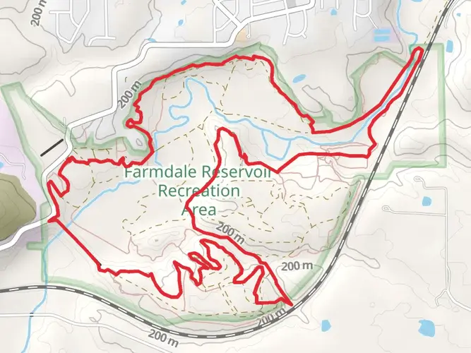
59.4 km
~2 days
221 m
Multi-Day
“Discover the serene Midwestern beauty and historical tapestry on the Rock Island Greenway and Trail.”
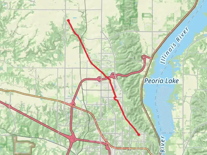
The Rock Island Greenway and Trail is a scenic journey stretching approximately 59 kilometers (about 37 miles) with a modest elevation gain of around 200 meters (about 656 feet), making it an engaging route for hikers of intermediate skill levels. Starting near Peoria County, Illinois, this point-to-point trail offers a blend of natural beauty, historical significance, and a chance to experience the tranquility of the Midwest.
Getting to the Trailhead To reach the trailhead, hikers can drive to a location near Peoria County, where parking is available. For those preferring public transportation, local bus services can be used to get close to the starting point, and from there, a short walk will lead you to the beginning of the trail.
Navigating the Trail As you embark on the Rock Island Greenway and Trail, you can expect a well-marked path that meanders through a variety of landscapes, including woodlands, prairies, and alongside streams. The trail is accessible year-round, though the experience can vary greatly with the seasons, from the lush greenery of summer to the stark beauty of winter.
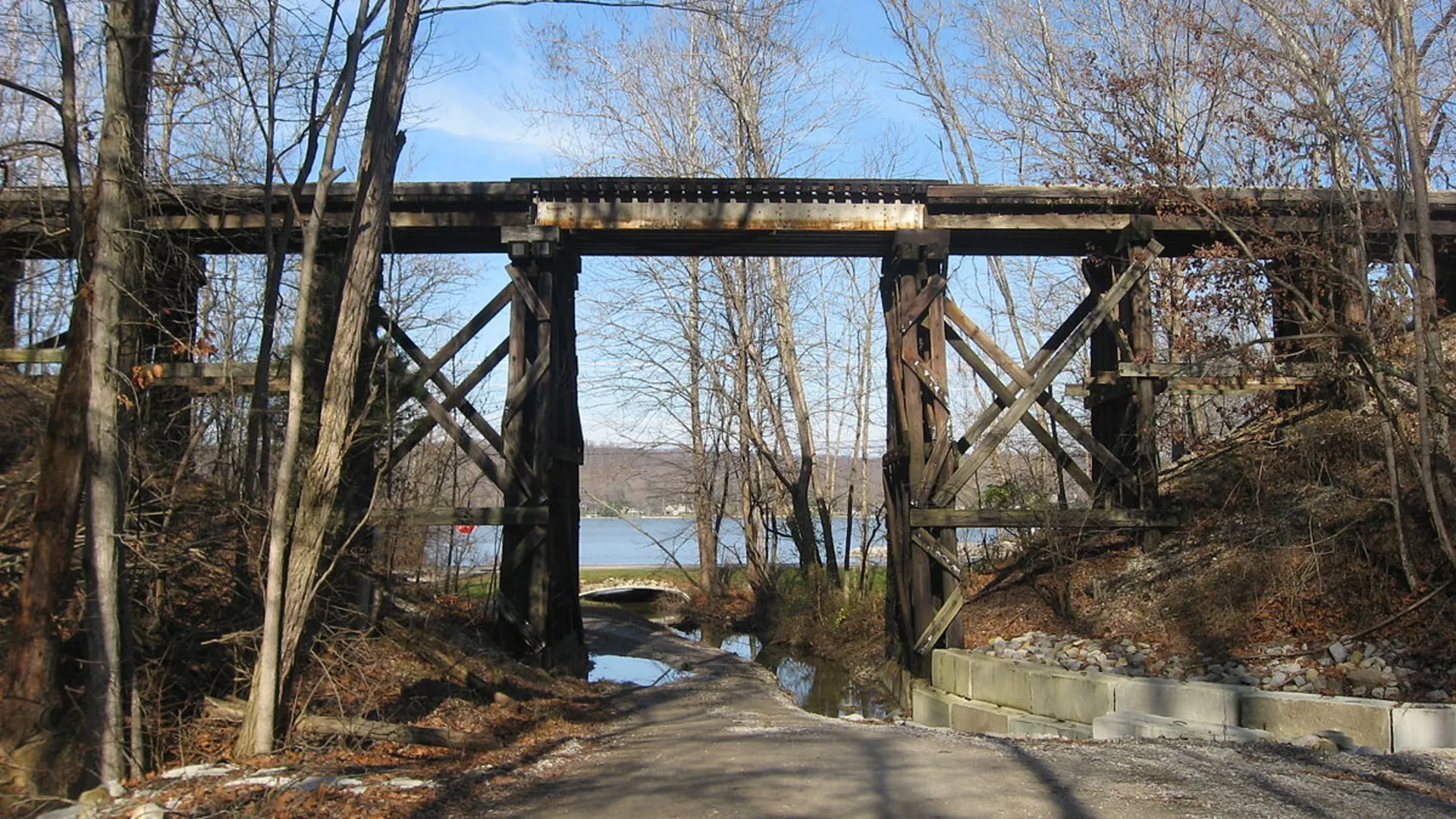
Landmarks and Nature One of the highlights of the trail is the opportunity to observe local wildlife, such as deer, birds, and small mammals, in their natural habitats. The trail also passes through several small towns and communities, offering a glimpse into the local culture and history. Along the way, you'll find interpretive signs that provide context about the region's past, including its development and the former use of the trail corridor as a railway line.
Historical Significance The Rock Island Greenway and Trail follows the path of the old Rock Island Railroad line, which played a crucial role in the development of the Midwest. As you hike, you'll be walking a route that once buzzed with the activity of trains carrying passengers and goods, contributing to the growth of the surrounding communities.
Preparation and Planning Before setting out, hikers should prepare for a full day's trek or plan for an overnight trip if they intend to complete the entire trail. It's advisable to download the trail map onto a navigation tool like HiiKER to ensure you stay on the right path. Make sure to pack enough water, snacks, and a first-aid kit, as well as appropriate clothing for the weather conditions.
Elevation and Distance The trail's elevation gain is gradual, making it a pleasant hike without any strenuous climbs. The 59 km distance can be broken into shorter sections if hikers prefer to tackle the trail in stages rather than all at once.
Conclusion The Rock Island Greenway and Trail offers a unique combination of natural beauty, wildlife viewing opportunities, and a touch of history, making it a memorable experience for hikers in the heart of Illinois. Whether you're looking for a leisurely walk or a multi-day adventure, this trail provides a window into the serene landscapes and rich past of the Midwest.

What to expect?
Activity types
Frequently asked questions
How long is the Rock Island Greenway and Trail in Peoria County, Illinois?
The Rock Island Greenway and Trail is 59.37 kilometers long, or about 36.9 miles. It is a point-to-point route in Peoria County with only 221 meters of total elevation gain, so the distance is the main challenge rather than steep climbing.
Is the Rock Island Greenway and Trail difficult, or is it good for beginners?
The Rock Island Greenway and Trail is rated easy, with a gentle 221 meters of elevation gain over its 59.37-kilometer length. That makes it approachable for beginners and steady walkers, especially when broken into shorter sections rather than completed in one outing.
Where can you park for the Rock Island Greenway and Trail near Peoria?
Parking for the Rock Island corridor is available at several access points near Peoria. Illinois Department of Natural Resources lists parking at Dunlap on Parks School Road and at the Peoria-Stark county line on North Cedar Bluff Road, and the Peoria greenway section also has access near the riverfront and Glen Oak Park. ([dnr.illinois.gov](https://dnr.illinois.gov/recreation/greenwaysandtrails/rockisland.html?utm_source=openai))
Is the Rock Island Greenway and Trail dog friendly?
The Rock Island Greenway section in Peoria is commonly used for walking dogs, and local trail listings describe it as dog friendly. Because this is a shared-use corridor through parks and public trail segments, dogs should be kept leashed and under control, especially on busier paved sections near the riverfront. ([alltrails.com](https://www.alltrails.com/trail/us/illinois/rock-island-greenway?utm_source=openai))
What towns and landmarks does the Rock Island Greenway and Trail connect?
The Rock Island route links Peoria’s greenway section with the state trail running north through Alta, Dunlap, Princeville, Wyoming, and Toulon. In Peoria, the greenway passes places such as the riverfront, Glen Oak Park, Trailside Center, and Safety Town before connecting into the longer former railroad corridor. ([dnr.illinois.gov](https://dnr.illinois.gov/recreation/greenwaysandtrails/rockisland.html?utm_source=openai))
Is the Rock Island Greenway and Trail paved the whole way?
The Peoria greenway section is paved, which is one reason it is popular for walking, running, and easier family outings. Farther north, the Rock Island Trail State Park section continues on the former rail corridor through communities including Dunlap, Princeville, Wyoming, and Toulon, so surface conditions can vary by segment. ([enjoyillinois.com](https://www.enjoyillinois.com/explore/listing/rock-island-greenway/?utm_source=openai))
Can the Rock Island Greenway and Trail be done as shorter day hikes instead of one long trip?
Yes. Even though the full Rock Island Greenway and Trail is 59.37 kilometers, the easy grade and multiple access points make it practical to hike in shorter sections. Popular break points include Peoria, Dunlap, and the county-line access, which lets hikers choose anything from a brief paved walk to a much longer point-to-point day. ([dnr.illinois.gov](https://dnr.illinois.gov/recreation/greenwaysandtrails/rockisland.html?utm_source=openai))
Comments and Reviews
User comments, reviews and discussions about the Rock Island Greenway and Trail, Illinois.
4.7
average rating out of 5
10 rating(s)