Download
3D Flyover
Add to list
More
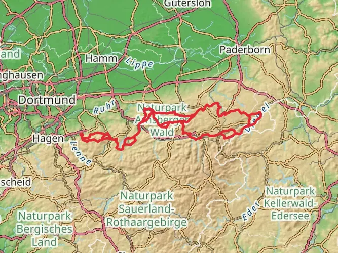
145.3 km
~6 days
2164 m
Multi-Day
“Embark on the Sintfeld-Höhenweg for a historic and scenic German hiking adventure.”
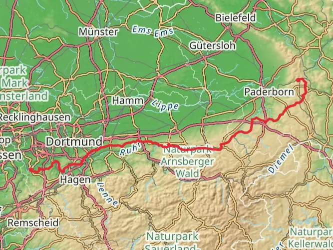
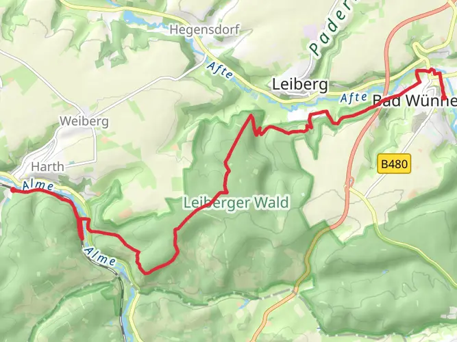
The Sintfeld-Höhenweg is a captivating loop trail that spans approximately 145 kilometers (around 90 miles) with an elevation gain of roughly 2100 meters (about 6900 feet), offering a medium difficulty rating that caters to hikers with a bit of experience under their belts. This trail is nestled near Kreis Paderborn in Germany, a region steeped in history and natural beauty.
Getting to the Trailhead
To embark on your journey along the Sintfeld-Höhenweg, you can arrive at the trailhead by either public transport or car. If you're opting for public transportation, the nearest major city is Paderborn, from which you can take regional buses towards the trail's starting point. For those driving, parking is available near the trailhead, which is conveniently located close to the town of Bad Wünnenberg.
Navigating the Trail
As you traverse the Sintfeld-Höhenweg, you'll find that the trail is well-marked, guiding you through a variety of landscapes, from dense forests to open meadows. The use of a navigation tool like HiiKER can be invaluable for staying on track and being aware of upcoming waypoints.
Landmarks and Scenery
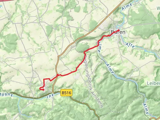
The trail offers a rich tapestry of sights, including panoramic views from the Eggegebirge, a low mountain range that forms part of the trail. You'll pass through charming villages and historical sites, such as the Wewelsburg Castle, a triangular Renaissance castle located near the village of Büren, which is about 20 kilometers (12 miles) into the hike.
Flora and Fauna
Nature enthusiasts will appreciate the diverse flora and fauna along the Sintfeld-Höhenweg. The trail meanders through the Teutoburg Forest, home to a variety of wildlife, including deer, foxes, and numerous bird species. The changing seasons bring different highlights, from the vibrant greens of spring to the rich golds and reds of autumn.
Historical Significance
The region is not only a haven for natural wonders but also a corridor of history. The Sintfeld-Höhenweg crosses areas that have been significant throughout the centuries, including ancient battlefields and trade routes. The trail itself is a testament to the area's commitment to preserving both its natural and cultural heritage.
Preparation and Planning
Before setting out, ensure you have adequate supplies for the journey. The trail can be completed in sections or as a multi-day hike, with accommodations available in the villages along the route. Water sources are present, but carrying a water filter or purification tablets is advisable. Weather can be variable, so pack layers and be prepared for changes in conditions.
Remember, the Sintfeld-Höhenweg is not just a physical challenge; it's an opportunity to immerse yourself in the history and natural splendor of this unique region of Germany. Whether you're a seasoned hiker or someone looking to delve deeper into the heart of the German countryside, this trail promises an enriching experience.

Frequently asked questions
How long is the Sintfeld-Höhenweg and how many days does the Sintfeld-Höhenweg take?
The Sintfeld-Höhenweg is a 145.33 km multi-day loop with 2,164 m of total ascent. A common way to hike it is over 6 to 7 days, and the official stage planning also breaks the route into manageable daily sections around the Sintfeld region, linking Büren, Lichtenau, and Bad Wünnenberg.
Where does the Sintfeld-Höhenweg start and finish near Bad Wünnenberg?
The Sintfeld-Höhenweg is a circular route in Kreis Paderborn, so it can be started in more than one place. Official stage planning begins in Büren at the Jesuit church Maria Immaculata on Burgstraße, while Bad Wünnenberg is also one of the main towns on the loop and a practical access point for joining the trail.
Does the Sintfeld-Höhenweg go through Bad Wünnenberg?
Yes. Bad Wünnenberg is one of the three main towns connected by the Sintfeld-Höhenweg, along with Büren and Lichtenau. One of the established stages runs from Blankenrode to Bad Wünnenberg, and the route around Bad Wünnenberg includes highlights such as the Aatal area and the town’s historic upper and lower districts.
What are the main sights on the Sintfeld-Höhenweg?
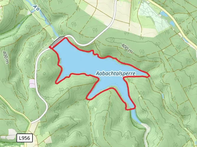
The Sintfeld-Höhenweg combines upland scenery with cultural landmarks across the southern Paderborn area. Notable places on or near the route include Wewelsburg, the forests near Büren, the Aabach reservoir area, Blankenrode, and Bad Wünnenberg, with a mix of woodland, open plateau views, and historic town centers along the loop.
Is the Sintfeld-Höhenweg difficult?
The Sintfeld-Höhenweg is generally considered an easier long-distance hike rather than a technical mountain route. Even so, 145.33 km and 2,164 m of climbing make it a serious multi-day walk, so the challenge comes more from the total distance and repeated daily mileage than from steep or exposed terrain.
Are dogs allowed on the Sintfeld-Höhenweg?
Dogs can be taken on much of the Sintfeld-Höhenweg, but there are important restrictions on specific sections. Around the Aabachtalsperre drinking-water reservoir, dogs are not allowed, so anyone hiking the full loop with a dog needs to plan carefully for that part of the route.
Is there an official map or stage overview for the Sintfeld-Höhenweg?
Yes. The Sintfeld-Höhenweg has an established stage overview, and the route is presented as a loop of about 144 to 145 km through Büren, Lichtenau, and Bad Wünnenberg. For on-trail navigation, the full route length and loop format make it well suited to following as a multi-day track rather than treating it as a single out-and-back walk.
Comments and Reviews
User comments, reviews and discussions about the Sintfeld-Höhenweg, Germany.
4.78
average rating out of 5
9 rating(s)