Download
Preview
Add to list
More
287.8 km
~15 days
6904 m
Multi-Day
“Embark on Offa's Dyke Path, a historic trek through stunning, diverse landscapes and ancient heritage.”
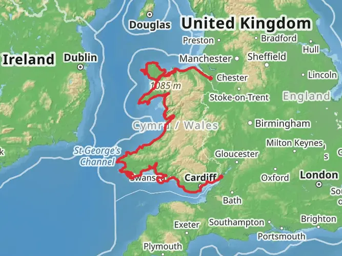
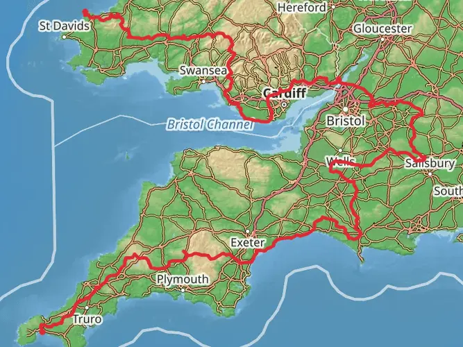
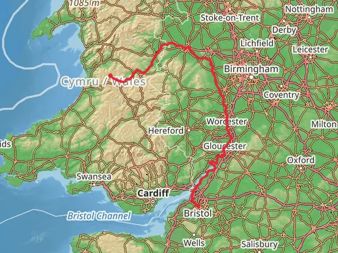
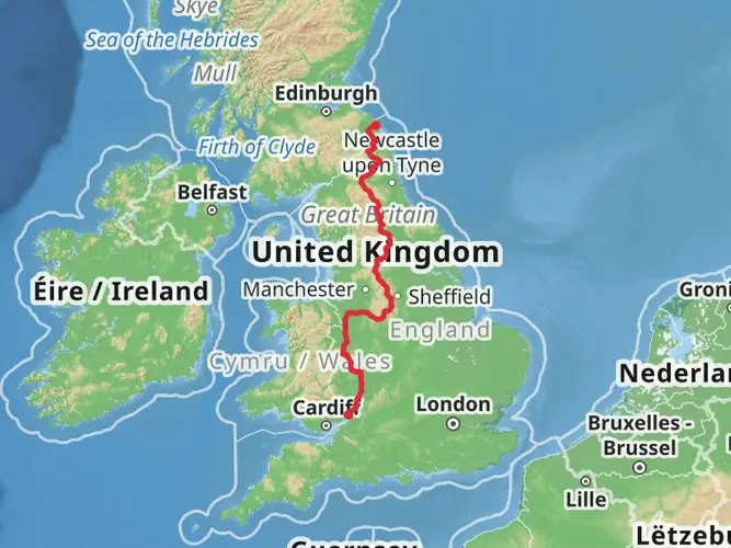
Offa's Dyke Path stretches approximately 288 kilometers (about 179 miles) and traverses a landscape rich in history and natural beauty, with an elevation gain of around 6900 meters (approximately 22,965 feet). This point-to-point trail begins near Sedbury Cliffs, close to Gloucestershire, England, and ends at the coastal town of Prestatyn in North Wales.
Getting to the Trailhead
To reach the southern trailhead near Sedbury Cliffs, hikers can travel to Chepstow, which is the nearest town with a train station. From Chepstow, it's a short taxi ride or a possible walk to the official start of the trail. For those driving, parking is available in Chepstow, and from there, you can make your way to the trailhead.
Navigating the Trail
Hikers can rely on HiiKER for detailed maps and navigation tools to guide them along Offa's Dyke Path. The trail is well-marked with acorn symbols and follows the England-Wales border, offering a mix of terrains including pastoral countryside, woodlands, and open ridges.
Historical Significance
The path is named after Offa, the Anglo-Saxon king of Mercia from 757 to 796 AD, who is traditionally believed to have ordered the construction of the dyke. The dyke itself is a large linear earthwork that roughly follows the current border between England and Wales. As you hike, you'll encounter remnants of the dyke, providing a tangible connection to the region's ancient past.
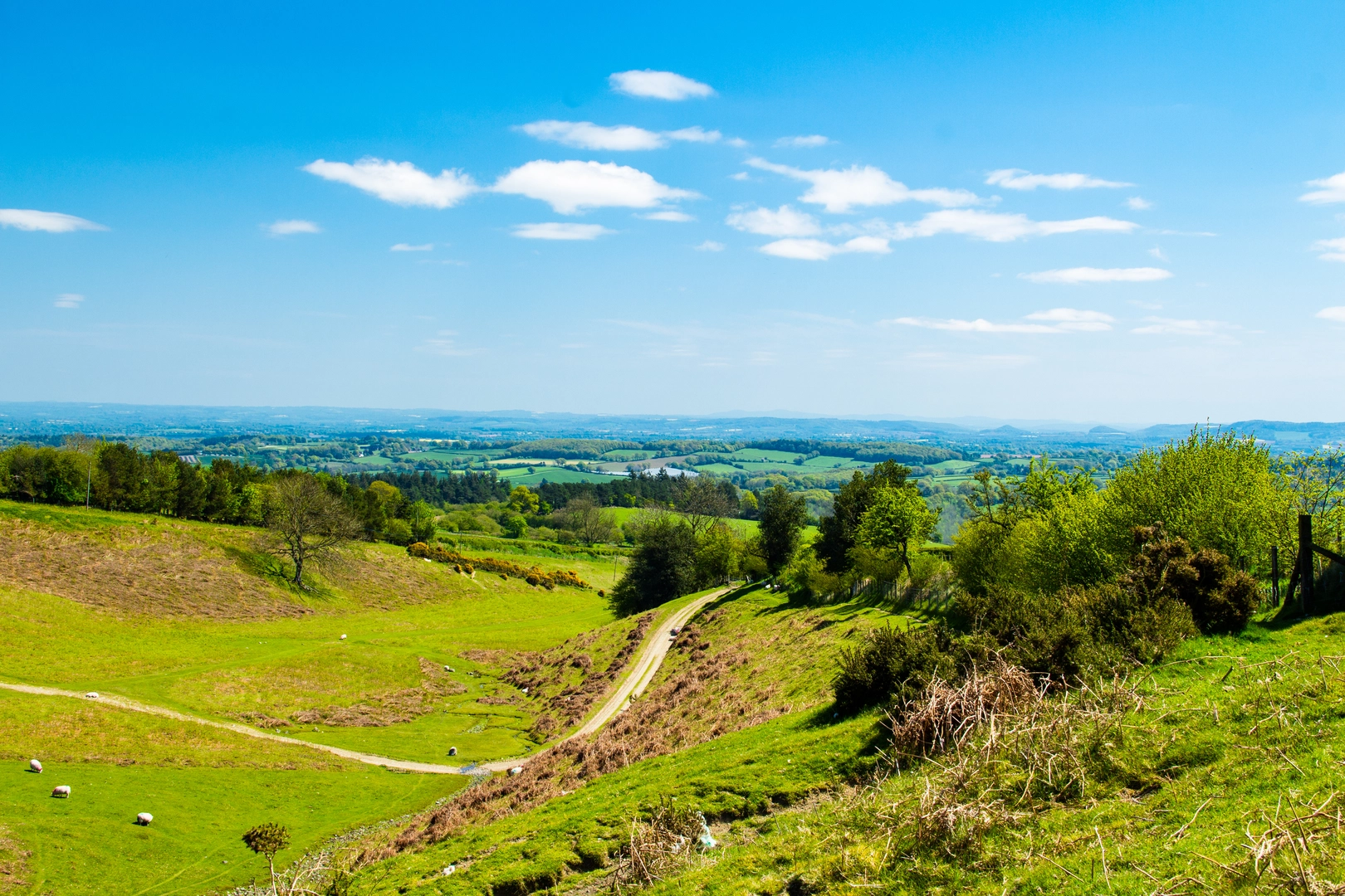
Landmarks and Scenery
One of the early highlights is the crossing of the River Wye in Chepstow, with the impressive Chepstow Castle nearby. As you progress, you'll pass through the scenic Wye Valley and the Black Mountains, offering panoramic views and challenging climbs.
Around the halfway mark, near Knighton, the trail reaches its highest point at the summit of Moel Famau, where hikers are rewarded with breathtaking views across the Vale of Clwyd towards the Irish Sea.
Wildlife and Nature
The path cuts through several nature reserves and areas of outstanding natural beauty, providing opportunities to spot wildlife such as badgers, foxes, and birds of prey. The trail also passes through the Shropshire Hills, an Area of Outstanding Natural Beauty, where the diverse habitats support a wide range of flora and fauna.
Preparation and Planning
Given the trail's length and varied terrain, hikers should be well-prepared with appropriate gear, including waterproof clothing and sturdy hiking boots. It's advisable to plan for multiple days of hiking, with accommodations ranging from campsites to B&Bs available along the route.
Seasonal Considerations
The path can be hiked year-round, but the best conditions are typically from spring to autumn. Summer offers the most reliable weather, while spring and autumn can provide a quieter experience with the added beauty of wildflowers or fall foliage.
Conclusion
Offa's Dyke Path is a journey through time, offering a unique blend of natural beauty and historical intrigue. Whether you're a seasoned hiker or someone looking to immerse themselves in the heritage of the British countryside, this trail promises an unforgettable adventure.

What to expect?
Activity types
Frequently asked questions
How long does it take to hike Offa's Dyke Path from Sedbury Cliffs to Prestatyn?
Offa's Dyke Path is 287.83 km, or about 179 miles, so most end-to-end hikes take around 12 to 14 days depending on pace and overnight stops. The route runs from Sedbury Cliffs near Chepstow to Prestatyn on the north Wales coast and includes about 6,904 m of climbing, which makes some days feel longer than the mileage suggests.
Where does Offa's Dyke Path start and finish, and which direction is best?
Offa's Dyke Path starts at Sedbury Cliffs near Chepstow on the Severn Estuary and finishes at Prestatyn on the north coast of Wales. Many walkers go south to north, beginning near Chepstow and ending at the sea in Prestatyn, but the trail is waymarked in both directions with the National Trail acorn symbol.
How do you get to the Offa's Dyke Path trailheads by public transport?
Chepstow is the main rail gateway for the southern end of Offa's Dyke Path, with the start at Sedbury Cliffs a short taxi ride or longer walk from town. At the northern end, Prestatyn railway station is about 0.5 km from the finish, and other useful rail access points along the route include Knighton and Welshpool.
Is Offa's Dyke Path difficult, and what kind of terrain does it have?
Offa's Dyke Path is generally rated medium, but the full route is a serious multi-day walk because it covers nearly 288 km with 6,904 m of ascent. Terrain changes constantly between farmland, woodland tracks, canal-side stretches, open ridges, and steeper hill sections, especially in upland areas such as the Black Mountains and the Clwydian Hills.
What are the main highlights and landmarks on Offa's Dyke Path?
Offa's Dyke Path links several standout sections along the England-Wales border, including Sedbury Cliffs at the southern start, stretches of the ancient earthwork itself, and major hill country farther north and west. Well-known highlights on or close to the route include Hatterrall Ridge in the Black Mountains, the trail hub at Knighton, White Castle near the southern half, and the final approach to Prestatyn on the Irish Sea coast.
Can you hike Offa's Dyke Path in sections instead of all at once?
Yes. Offa's Dyke Path is commonly walked in sections because rail access at places such as Chepstow, Knighton, Welshpool, and Prestatyn makes it practical to break up the route. The distance table used for the National Trail also reflects major intermediate points, so many walkers plan the trail as a series of shorter trips rather than one continuous 287.83 km journey.
Comments and Reviews
User comments, reviews and discussions about the Offa's Dyke Path, England.
4.84
average rating out of 5
57 rating(s)