Download
Preview
Add to list
More
117.2 km
~7 days
4153 m
Multi-Day
“Embark on the scenic High Sierra Trail, a 117-km journey through majestic mountains, diverse wildlife, and rich history, from Sequoia's giants to Whitney's peak.”
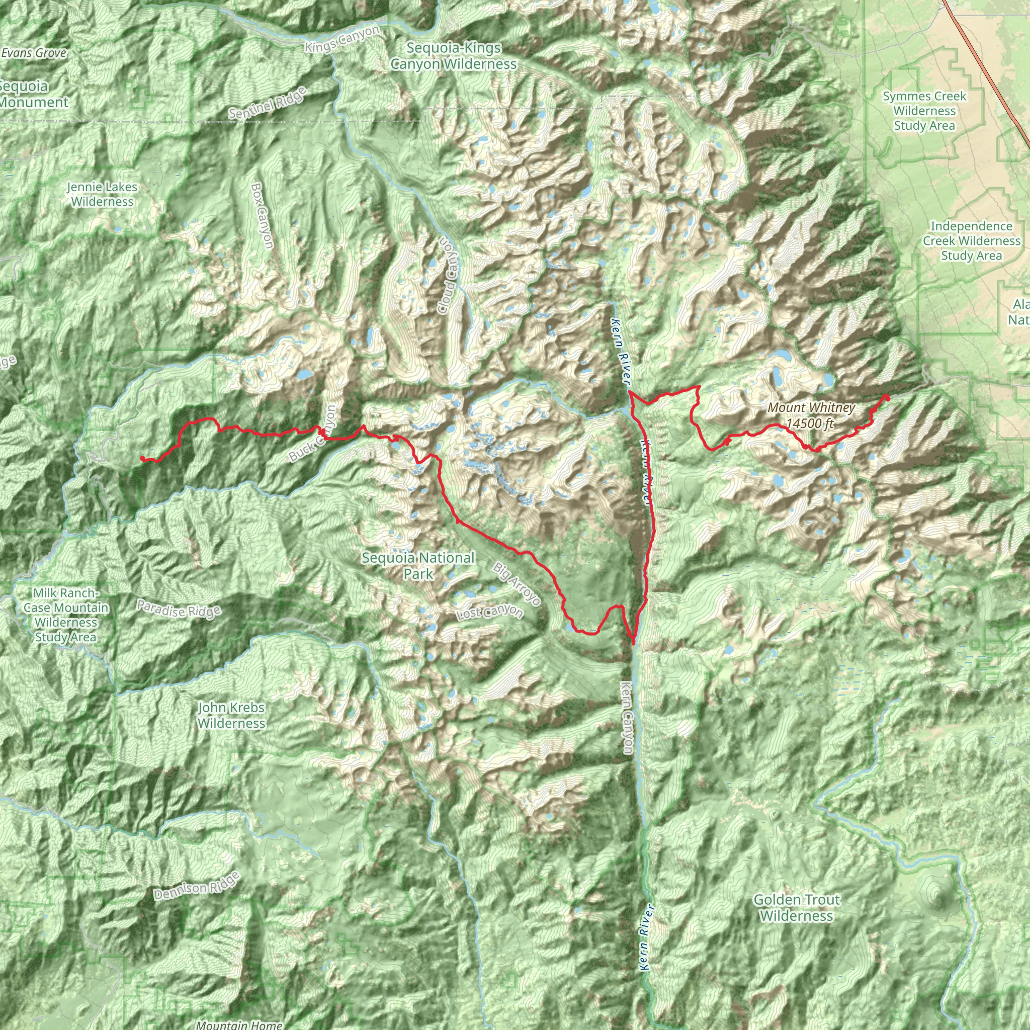
The High Sierra Trail stretches approximately 117 kilometers (about 72.7 miles) and traverses the Sierra Nevada mountain range with an elevation gain of around 4,100 meters (approximately 13,500 feet). This point-to-point trail begins near Tulare County, California, at the Crescent Meadow in Sequoia National Park, which is accessible by car. For those relying on public transportation, the closest town with bus services is Visalia, from where you can take the Sequoia Shuttle to the park during the summer months.
Getting to the Trailhead
To reach the starting point at Crescent Meadow, you'll drive through the Ash Mountain Entrance of Sequoia National Park. The trailhead is well-marked and offers parking for those who arrive by car. Ensure you have arranged for transportation from the endpoint at Whitney Portal, as this is a point-to-point hike.
Navigating the Trail
The High Sierra Trail is well-maintained and marked, but due to its length and remote nature, it's crucial to have a reliable navigation tool. HiiKER is an excellent resource for trail maps and navigation, ensuring you stay on the correct path throughout your journey.
Landmarks and Scenery
As you embark on the High Sierra Trail, you'll be greeted by the lush meadows and giant sequoias of Sequoia National Park. The trail offers a diverse array of landscapes, including alpine meadows, lakes, and high mountain passes. One of the first significant landmarks you'll encounter is Bearpaw Meadow, about 18 kilometers (11.2 miles) from the trailhead, which provides stunning views and a backcountry campsite for overnight stays.
Continuing on, you'll ascend to Hamilton Lakes, a picturesque series of lakes nestled in a granite basin. This area, about 32 kilometers (20 miles) into the hike, is a popular spot for rest and photography. The challenging climb up to Kaweah Gap follows, a high pass that offers panoramic views of the Great Western Divide.
Wildlife and Nature
The High Sierra Trail is home to a rich variety of wildlife, including black bears, marmots, and deer. Hikers should be knowledgeable about bear safety and proper food storage. The trail also traverses through different ecosystems, from the montane forests to the alpine zones, each with its unique flora and fauna.
Historical Significance
The region is steeped in history, with the High Sierra Trail itself being constructed in the 1920s and 1930s. It was one of the first Sierra trails designed for recreational use. As you hike, you're following in the footsteps of indigenous peoples, early explorers, and mountaineers who have traversed these mountains for centuries.
End of the Trail
The trail culminates at Mount Whitney, the highest peak in the contiguous United States, with an elevation of 4,421 meters (14,505 feet). The final ascent to Whitney Portal is a challenging yet rewarding experience, with an elevation gain of over 1,600 meters (5,249 feet) in the last 17 kilometers (10.5 miles) of the trail.
Preparation and Planning
Due to the trail's difficulty and remote nature, it's essential to be well-prepared. This includes obtaining necessary permits, being in good physical condition, and carrying the right gear for varying weather conditions. It's also wise to plan for food resupplies, as the hike typically takes around 7 to 10 days to complete.
Seasonal Considerations
The best time to hike the High Sierra Trail is from July to September when the snow has melted, and the weather is more stable. However, weather in the high Sierra can be unpredictable, and hikers should be prepared for sudden changes, including afternoon thunderstorms.
Safety and Regulations
Always check current trail conditions and regulations before setting out. Wilderness permits are required for overnight stays, and quotas are in place to protect the environment. Be sure to practice Leave No Trace principles to preserve the beauty and wilderness of the High Sierra Trail for future generations.
What to expect?
Activity types
Comments and Reviews
User comments, reviews and discussions about the High Sierra Trail, California.
5.0
average rating out of 5
4 rating(s)

