Download
Preview
Add to list
More
38.5 km
~1 day 4 hrs
1057 m
Point-to-Point
“Embark on a 38-km trek through Yellowstone's breathtaking landscapes, from Cave Falls to Bechler Ranger Station.”
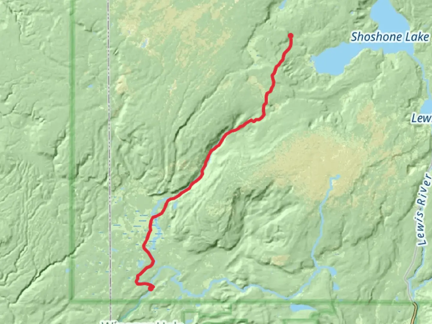
Starting near Teton County, Wyoming, the Bechler River Walk via Cave Falls is a point-to-point trail that spans approximately 38 kilometers (around 24 miles) with an elevation gain of about 1000 meters (3280 feet). This trail takes you through the stunning landscapes of Yellowstone National Park, offering a medium difficulty rating suitable for moderately experienced hikers.### Getting There To reach the trailhead, you can drive or use public transportation. If driving, head towards Teton County, Wyoming, and follow signs to Yellowstone National Park. The nearest significant landmark to the trailhead is Cave Falls, which is accessible via Cave Falls Road. For those relying on public transport, the nearest major hub is Jackson, Wyoming. From Jackson, you can take a shuttle or taxi service to the trailhead.### Trail Overview The trail begins near Cave Falls, a spectacular waterfall that marks the starting point of your journey. Cave Falls itself is a sight to behold, with water cascading down a 20-foot drop, creating a misty, ethereal atmosphere. From here, the trail meanders through lush meadows and dense forests, offering a diverse range of flora and fauna.### Key Landmarks and Sections - Cave Falls to Bechler Meadows (0-10 km / 0-6 miles): The first section of the trail is relatively flat, making it a good warm-up for the more challenging parts ahead. You'll pass through Bechler Meadows, a vast expanse of wildflowers and grasses that is particularly stunning in late spring and early summer. Keep an eye out for elk and bison grazing in the meadows.
- Bechler Meadows to Bechler Canyon (10-20 km / 6-12 miles): As you continue, the trail begins to ascend gradually. This section takes you through Bechler Canyon, where the terrain becomes more rugged. The canyon walls rise steeply on either side, and the Bechler River flows swiftly below. This area is known for its geothermal features, including hot springs and fumaroles. Be cautious around these areas, as the ground can be unstable.- Bechler Canyon to Three Rivers Junction (20-30 km / 12-18 miles): The trail continues to climb, reaching its highest point near Three Rivers Junction. This section is more strenuous, with several steep inclines. However, the effort is rewarded with breathtaking views of the surrounding mountains and valleys. Three Rivers Junction is a great spot to take a break and enjoy the scenery.- Three Rivers Junction to Bechler Ranger Station (30-38 km / 18-24 miles): The final stretch of the trail descends gradually towards the Bechler Ranger Station. This section is less challenging, allowing you to enjoy the serene beauty of the forest and river. The ranger station marks the end of the trail, where you can rest and reflect on your journey.### Wildlife and Nature Yellowstone National Park is home to a diverse range of wildlife, including bears, wolves, elk, bison, and numerous bird species. Always carry bear spray and be aware of your surroundings. The park's geothermal features are another highlight, with hot springs, geysers, and fumaroles dotting the landscape. These natural wonders are a reminder of the park's volcanic origins.### Historical Significance The Bechler River area has a rich history, with evidence of Native American habitation dating back thousands of years. The region was also explored by early trappers and settlers in the 19th century. The trail itself follows routes used by these early adventurers, offering a glimpse into the past.### Navigation For navigation, it is highly recommended to use the HiiKER app, which provides detailed maps and real-time updates. This will help you stay on track and ensure a safe and enjoyable hike.Prepare well, respect the natural environment, and enjoy the incredible journey through one of America's most iconic national parks.

What to expect?
Activity types
Comments and Reviews
User comments, reviews and discussions about the Bechler River Walk via Cave Falls, Wyoming.
4.65
average rating out of 5
49 rating(s)