Download
Preview
Add to list
More
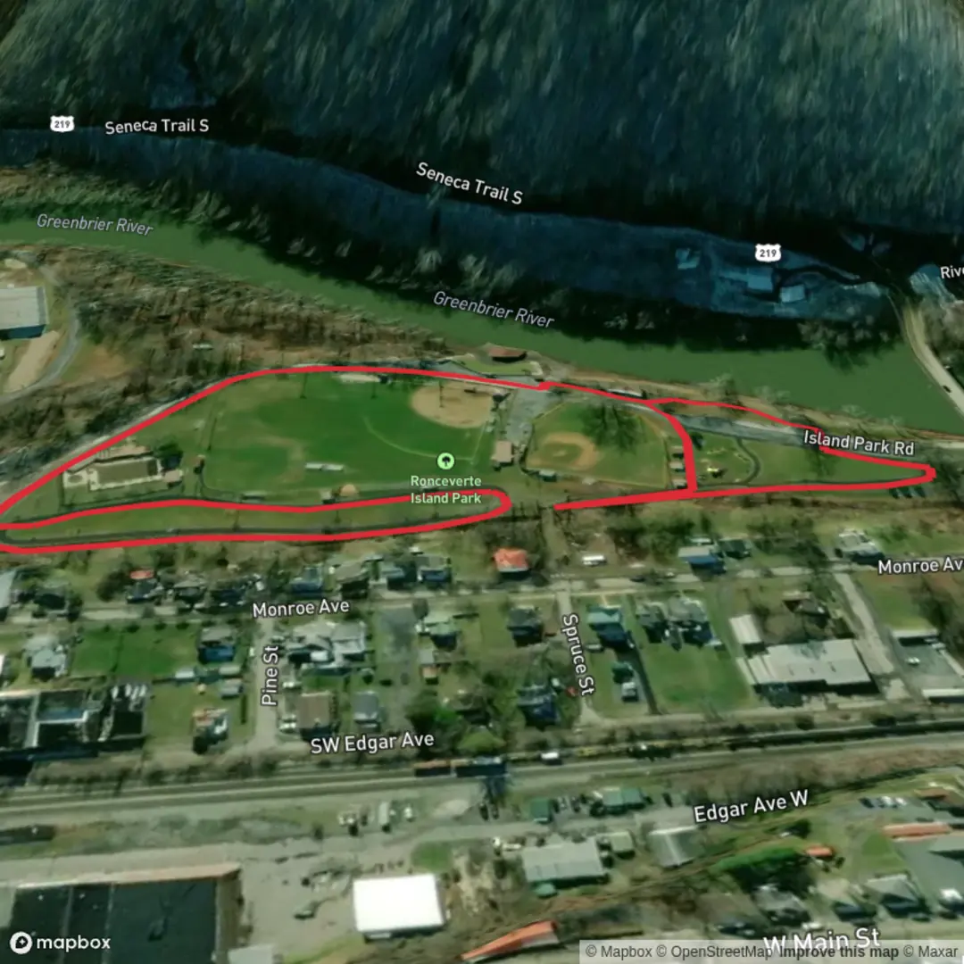
1.6 km
~19 min
0 m
Loop
“A gentle riverside loop with Greenbrier River glimpses and inviting pauses—best for an easy stroll.”
A short, flat loop through a riverside park setting, this walk is well-suited to families, casual strolls, and anyone looking for an easy leg-stretcher with frequent views of the Greenbrier River and plenty of places to pause.
Distance & effort - Length: ~2 km / 1.2 miles - Elevation gain: ~0 m / ~0 ft (expect only tiny rises where the path meets bridges, ramps, or slightly higher ground near the park edge) - Estimated difficulty: Easy (generally level, short, and forgiving underfoot)
Where the hike starts (nearest landmark / address) “Ronceverte Island Park” is most closely associated with the Island Park area along the Greenbrier River in Ronceverte, West Virginia, near the town’s riverfront and park access points. If you’re navigating, aim for Ronceverte Island Park / Island Park (Greenbrier River) as your destination, then use HiiKER to confirm the exact trailhead pin and the loop direction that matches the on-the-ground paths.
Getting to the start - By car: From central Ronceverte, follow local streets toward the Greenbrier River riverfront/park access. Parking is typically in small park lots or along nearby streets where permitted. Arrive a little earlier on warm weekends—river parks can fill up quickly. - By public transport: Service in this part of the Greenbrier Valley can be limited and schedules vary. The most reliable approach is usually a taxi/rideshare from Lewisburg or nearby towns if you’re arriving by intercity bus or rail to the region. If you’re already staying in Ronceverte, the start is often reachable by a short walk through town toward the riverfront. Use HiiKER to identify the closest access point to your lodging.
What the loop is like underfoot
Expect a park-style path network: typically mown grass edges, compacted dirt, gravel, or paved segments depending on which connectors you choose to complete the loop. Because the route is essentially flat, the main “difficulty” factors are surface conditions: - After rain or snowmelt, low-lying riverside ground can turn soft or muddy, especially where foot traffic cuts corners. - In warmer months, grass and packed soil can become slick with morning dew. - If any portion runs close to the riverbank, watch for roots, uneven edges, and minor erosion.
Landmarks, scenery, and what to watch for
The highlight is the Greenbrier River corridor—a classic Appalachian valley river setting with open park lawns transitioning into riparian trees and brush. On a 2 km / 1.2 mile loop, you’ll likely encounter: - River viewpoints where the water is visible through breaks in the trees - Open green space (good for picnics, kids, and relaxed pacing) - Shaded stretches under riverside trees—welcome on hot days, but also where insects can be more noticeable
If the loop uses any small bridges or narrow connectors, slow down where paths pinch—these are the spots where cyclists, runners, and dog walkers tend to converge.
Nature and wildlife (seasonal expectations)
Riverside parks in this region commonly support a mix of edge-habitat wildlife: - Birdlife: songbirds in the trees and water-associated birds along calmer river sections. Early morning is usually the most active time. - Small mammals: squirrels and other common park species; you may also see signs of animals using the river corridor as a travel route. - Insects: expect mosquitoes and gnats near still or slow water in late spring through summer; consider repellent. - Plants: riparian vegetation can include dense summer growth—watch for poison ivy along trail margins and around tree bases. Staying on the main tread helps.
Navigation and timing
This is short enough that many people can follow it by sight, but park path networks can have multiple spurs. Use HiiKER to: - Confirm you’re on the intended loop (especially if there are parallel riverside paths) - Check for any short detours that add a scenic river bend without adding much distance - Keep track of your position if you decide to explore side paths and then rejoin the loop
A relaxed pace with stops typically takes 30–60 minutes for 2 km / 1.2 miles, depending on how often you pause at the river.
Safety and practical prep
Even easy, flat riverside loops have a few consistent hazards: - High water / flooding: After heavy rain, riverside parks can have standing water, saturated ground, or temporarily closed sections. If the river looks high or fast, keep extra distance from the bank. - Ticks: In grassy edges and brushy margins, do a quick tick check afterward, especially in spring and early summer. - Heat and sun: Open lawns can be surprisingly exposed. Bring water even for a short walk, particularly in humid conditions. - Footwear: Light hikers or trail runners are fine; after rain, choose something with a bit of tread.
Historical context of the area
Ronceverte sits in the Greenbrier Valley, a corridor shaped by river travel, settlement, and later transportation routes through the Appalachians. River-adjacent parks like this often occupy land that historically would have been valued for access to water, fertile floodplain soils, and movement along the valley. The town itself developed in a region where rail and river corridors played an outsized role in connecting communities and supporting local industry and agriculture—context you can still feel in

Comments and Reviews
User comments, reviews and discussions about the Ronceverte Island Park Loop, West Virginia.
average rating out of 5
0 rating(s)