Download
Preview
Add to list
More
12.2 km
~3 hrs 35 min
693 m
Loop
“Embark on a 12-kilometer loop through Larrabee Park's lush forests and serene lakes, capturing Pacific Northwest beauty.”
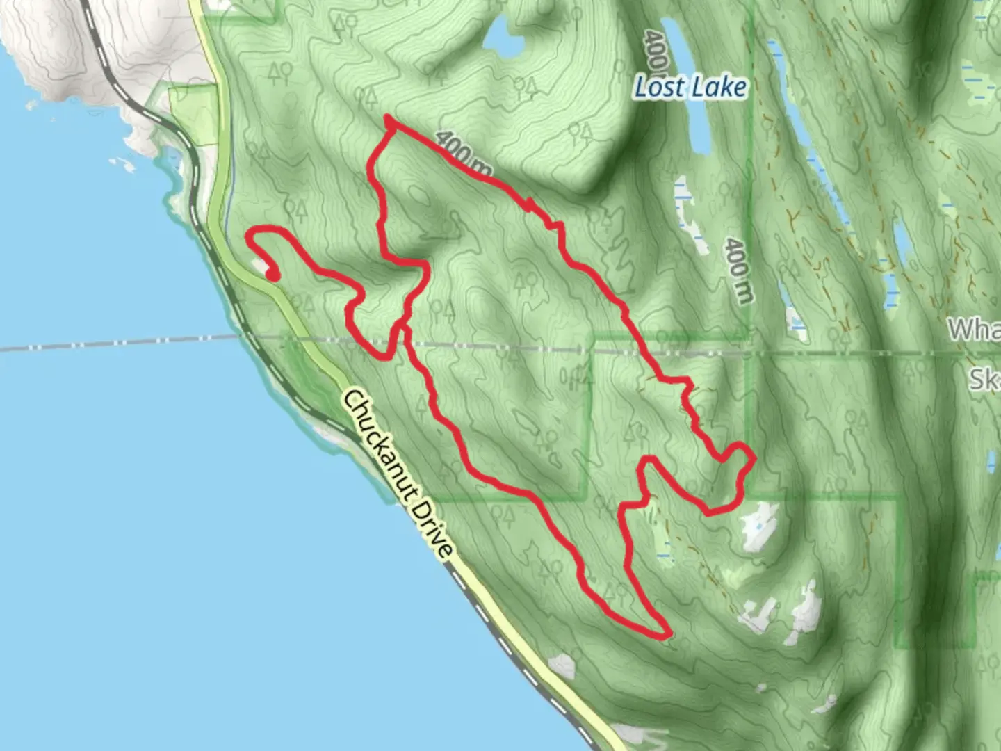
Starting your adventure near Whatcom County, Washington, the Larrabee and South Lost Lake Trail offers a captivating loop of approximately 12 kilometers (7.5 miles) with an elevation gain of around 600 meters (1,970 feet). This medium-difficulty trail is perfect for those looking to immerse themselves in the natural beauty of the Pacific Northwest.
Getting There
To reach the trailhead, you can drive or use public transportation. If driving, head towards Larrabee State Park, located along Chuckanut Drive (State Route 11). The nearest significant landmark is the Larrabee State Park entrance, which provides ample parking. For those using public transport, the Whatcom Transportation Authority (WTA) offers bus services that can get you close to the park, but you may need to arrange a taxi or rideshare for the final leg of the journey.
Trail Overview
The trail begins at the Larrabee State Park trailhead, where you'll find well-marked signs guiding you through the lush forest. The initial section of the trail is relatively gentle, allowing you to acclimate to the surroundings. As you progress, the trail starts to ascend, offering a moderate challenge with a steady climb.
Key Landmarks and Points of Interest
- Fragrance Lake: About 3 kilometers (1.9 miles) into the hike, you'll encounter a spur trail leading to Fragrance Lake. This serene lake is a great spot for a short break and some picturesque photos.
- Lost Lake: Continuing on the main trail, you'll reach Lost Lake at approximately the halfway point. This larger lake is surrounded by dense forest and offers a peaceful setting for a longer rest or even a picnic.
- Viewpoints: As you ascend, several viewpoints provide stunning vistas of the surrounding mountains and the Puget Sound. These are perfect spots to catch your breath and take in the scenery.
Flora and Fauna
The trail is rich in biodiversity. You'll traverse through old-growth forests dominated by Douglas fir, western red cedar, and hemlock. Keep an eye out for local wildlife, including black-tailed deer, various bird species, and occasionally, black bears. The area is also known for its vibrant wildflower displays in the spring and summer months.
Historical Significance
Larrabee State Park holds the distinction of being Washington's first state park, established in 1915. The park and surrounding trails are named after Charles Xavier Larrabee, a prominent businessman who played a significant role in the development of the region. The park's history adds an enriching layer to your hiking experience, connecting you to the early conservation efforts in the state.
Navigation and Safety
Given the trail's moderate difficulty, it's advisable to use a reliable navigation tool like HiiKER to keep track of your progress and ensure you stay on the correct path. The trail is well-marked, but having a digital map can be reassuring, especially in areas where the path may be less distinct.
Final Stretch
The descent back towards the trailhead offers a gentle relief after the climb, allowing you to enjoy the final leg of your journey. As you loop back to the starting point, take a moment to appreciate the diverse landscapes and the sense of accomplishment that comes with completing this rewarding hike.

What to expect?
Activity types
Comments and Reviews
User comments, reviews and discussions about the Larrabee and South Lost Lake Trail, Washington.
4.62
average rating out of 5
13 rating(s)