Download
Preview
Add to list
More
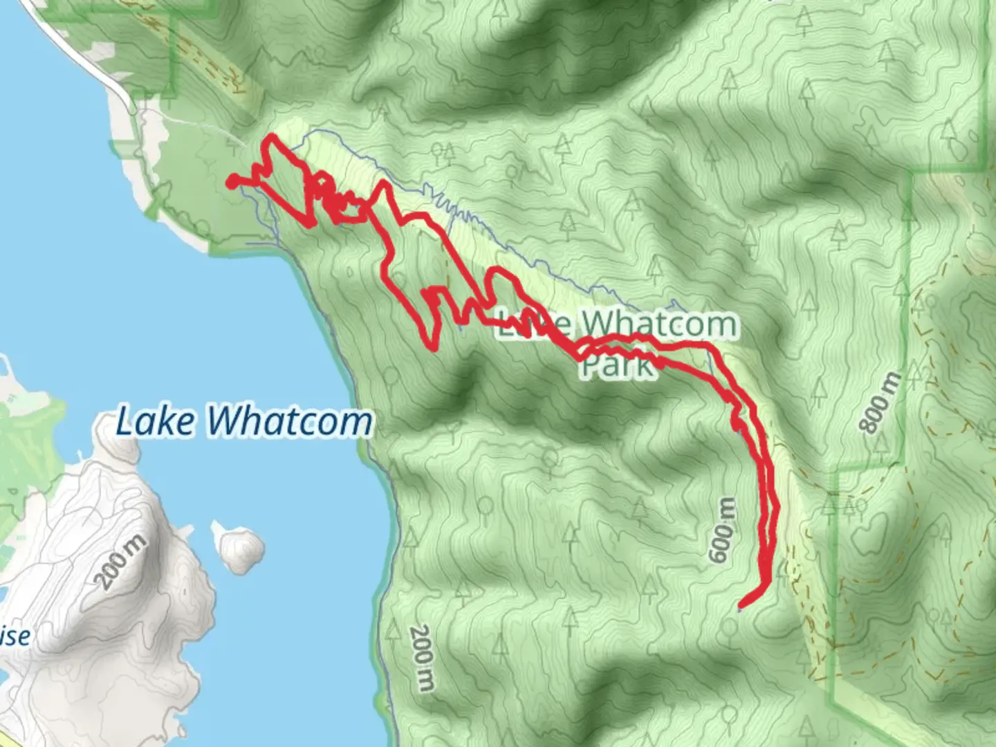
14.2 km
~4 hrs 29 min
994 m
Loop
“"Explore the Chanterelle Trail Upper Loop for a challenging 14 km hike with breathtaking views and rich history."”
Starting your adventure near Whatcom County, Washington, the Chanterelle Trail Upper Loop offers a rewarding 14 km (approximately 8.7 miles) journey with an elevation gain of around 900 meters (2,950 feet). This loop trail is rated as medium difficulty, making it suitable for moderately experienced hikers.
Getting There
To reach the trailhead, you can drive or use public transportation. If driving, head towards Lake Whatcom Park, located at 3220 North Shore Road, Bellingham, WA. There is ample parking available at the trailhead. For those using public transport, the nearest bus stop is at the intersection of North Shore Road and Britton Road, serviced by the Whatcom Transportation Authority (WTA) Route 512. From there, it's a short walk to the trailhead.
Trail Overview
The Chanterelle Trail Upper Loop begins with a gentle ascent through a lush forest of Douglas firs and western red cedars. The initial 2 km (1.2 miles) are relatively easy, allowing you to warm up before the trail starts to climb more steeply. As you gain elevation, you'll notice the forest floor is often carpeted with ferns and moss, creating a serene and almost otherworldly atmosphere.
Significant Landmarks and Nature
Around the 4 km (2.5 miles) mark, you'll reach a series of switchbacks that offer glimpses of Lake Whatcom through the trees. This section is more strenuous, with an elevation gain of about 300 meters (985 feet) over the next 2 km (1.2 miles). Keep an eye out for chanterelle mushrooms, especially in the fall, as they are abundant in this area and give the trail its name.
Wildlife
The trail is home to a variety of wildlife, including black-tailed deer, raccoons, and occasionally black bears. Birdwatchers will enjoy spotting species like the pileated woodpecker, varied thrush, and bald eagles soaring above the lake. Always carry a map and compass, or better yet, use the HiiKER app for real-time navigation and updates.
Historical Significance
The region around Lake Whatcom has a rich history, originally inhabited by the Lummi and Nooksack tribes. The lake itself was a crucial resource for these communities, providing fish and fresh water. In the late 19th and early 20th centuries, the area saw a boom in logging activities, remnants of which can still be seen along the trail in the form of old logging roads and stumps.
Reaching the Summit
At approximately 7 km (4.3 miles), you'll reach the highest point of the trail, offering panoramic views of Lake Whatcom and the surrounding mountains. This is a great spot to take a break, have a snack, and soak in the scenery. The elevation here is about 900 meters (2,950 feet) above sea level.
Descent and Return
The descent begins gradually, winding through more dense forest and eventually leveling out as you approach the lower elevations. The final 3 km (1.9 miles) are relatively flat and easy, allowing you to cool down as you make your way back to the trailhead.
Preparation Tips
Given the elevation gain and the length of the trail, it's essential to bring plenty of water, snacks, and appropriate clothing. Weather can change rapidly, so layers are recommended. Good hiking boots are a must due to the uneven and sometimes slippery terrain. Always check trail conditions before you go, and consider using the HiiKER app for the latest updates and navigation assistance.
This trail offers a perfect blend of natural beauty, moderate challenge, and historical intrigue, making it a must-visit for any hiking enthusiast in the Whatcom County area.

What to expect?
Activity types
Comments and Reviews
User comments, reviews and discussions about the Chanterelle Trail Upper Loop, Washington.
4.55
average rating out of 5
11 rating(s)