Download
Preview
Add to list
More
18.1 km
~5 hrs 2 min
855 m
Point-to-Point
“Embark on the scenic Mica Peak Trail for an 18 km adventure with stunning views and rich history.”
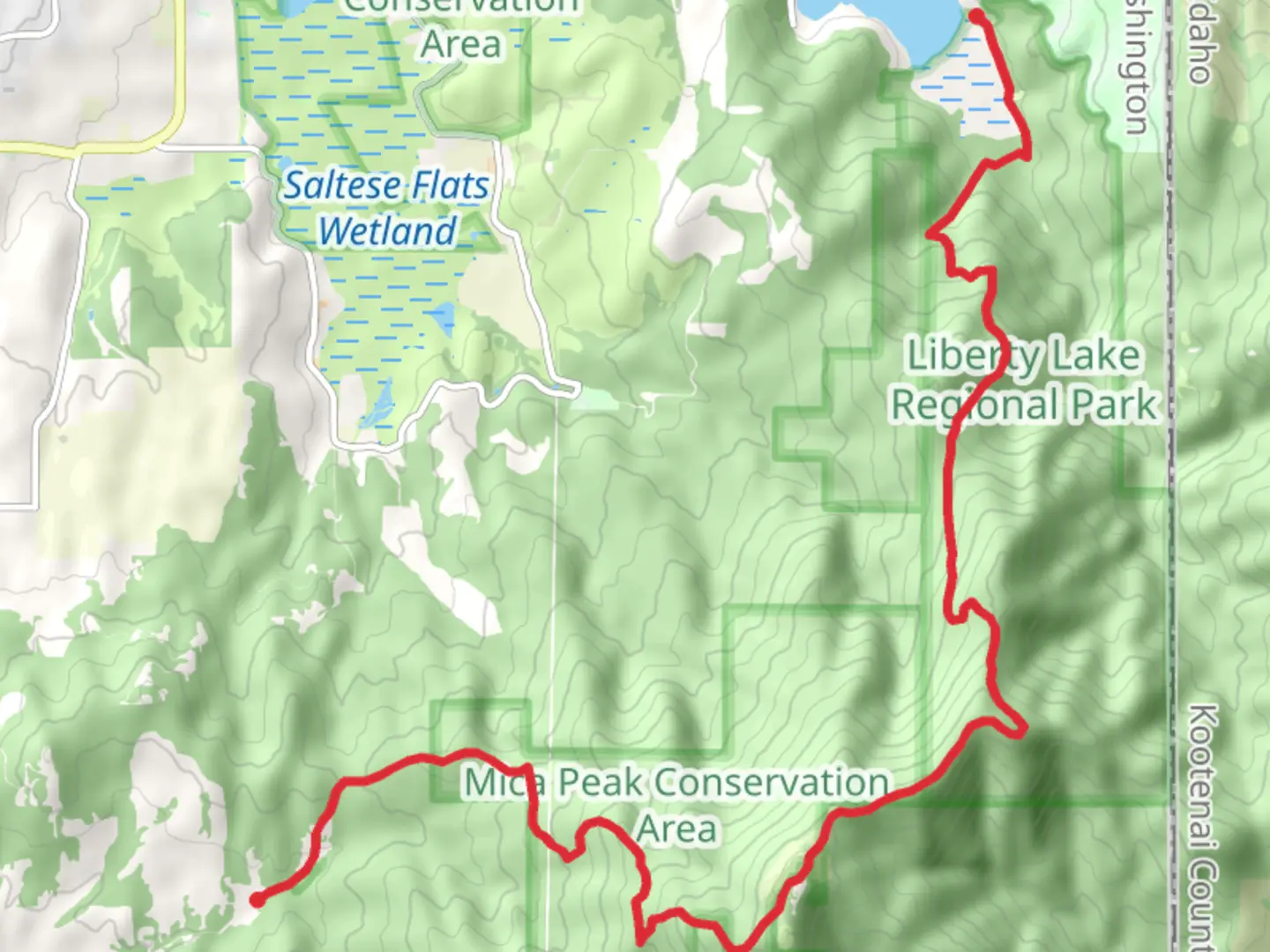
Starting your adventure near Spokane County, Washington, the Mica Peak Trail and Maintenance Trail offers a rewarding 18 km (approximately 11 miles) journey with an elevation gain of around 800 meters (2,625 feet). This point-to-point trail is rated as medium difficulty, making it suitable for hikers with some experience.
Getting There
To reach the trailhead, you can drive or use public transportation. If driving, head towards the Liberty Lake Regional Park, which is the nearest significant landmark. From Spokane, it's about a 30-minute drive via I-90 E. For those using public transport, you can take a bus to Liberty Lake and then a short taxi ride to the park.
Trail Overview
The trail begins at the Liberty Lake Regional Park, a well-known starting point. As you set off, you'll find yourself immersed in a lush forest of pine and fir trees. The initial 3 km (1.9 miles) are relatively gentle, allowing you to warm up before the more challenging sections.
Elevation and Terrain
Around the 5 km (3.1 miles) mark, the trail starts to ascend more steeply. You'll gain approximately 400 meters (1,312 feet) in elevation over the next 4 km (2.5 miles). The terrain here is rocky and can be slippery, especially after rain, so good hiking boots are essential.
Landmarks and Nature
As you climb, keep an eye out for the stunning views of the Spokane Valley and the distant peaks of the Selkirk Mountains. At around 8 km (5 miles), you'll come across a small, serene alpine meadow, a perfect spot for a short break and some photos.
Wildlife
The area is rich in wildlife. You might spot deer, elk, and various bird species, including hawks and eagles. Be cautious and respectful of the wildlife, maintaining a safe distance at all times.
Historical Significance
Mica Peak has a rich history. The region was historically inhabited by the Spokane Tribe, and you might come across some interpretive signs along the trail that provide insights into their way of life. Additionally, during the early 20th century, the area was used for logging, and remnants of old logging roads can still be seen.
Navigation
Given the trail's length and elevation changes, it's advisable to use a reliable navigation tool like HiiKER to keep track of your progress and ensure you stay on the correct path. The trail is well-marked, but having a digital map can be very helpful, especially in foggy or low-visibility conditions.
Final Stretch
The final 4 km (2.5 miles) of the trail involve a descent towards the endpoint. This section can be quite steep, so trekking poles might be useful to help maintain balance. You'll eventually reach the end of the trail near the Mica Peak Conservation Area, where you can arrange for a pickup or head back to Liberty Lake Regional Park if you're doing an out-and-back hike.
Preparation Tips
Ensure you carry enough water, snacks, and a first-aid kit. Weather can change rapidly, so layers and a waterproof jacket are recommended. Always let someone know your hiking plans and expected return time.
Enjoy your hike on the Mica Peak Trail and Maintenance Trail, and take in the natural beauty and historical richness of the area.

What to expect?
Activity types
Comments and Reviews
User comments, reviews and discussions about the Mica Peak Trail and Maintenance Trail, Washington.
4.5
average rating out of 5
16 rating(s)