Download
Preview
Add to list
More
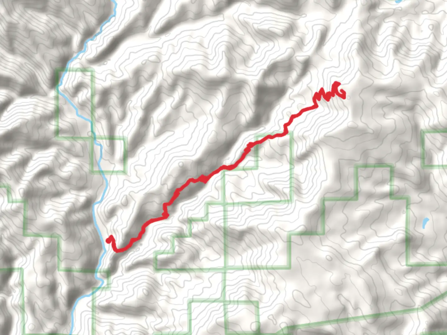
25.1 km
~7 hrs 31 min
1496 m
Out and Back
“The Three Corner Rock Trail offers a challenging yet rewarding 25 km hike with breathtaking views and rich biodiversity.”
Starting near Skamania County, Washington, the Three Corner Rock Trail is an invigorating out-and-back hike that spans approximately 25 kilometers (15.5 miles) with an elevation gain of around 1400 meters (4593 feet). This trail is rated as medium difficulty, making it suitable for moderately experienced hikers.
Getting There
To reach the trailhead, you can drive or use public transport. If driving, head towards Skamania County and look for the trailhead near the town of Stevenson, Washington. For those using public transport, the nearest significant landmark is Stevenson, WA, where you can find local bus services that connect to the trailhead area.
Trail Overview
The trail begins with a steady ascent through dense forest, offering a serene start with the sounds of nature all around. As you progress, the trail becomes steeper, and the forest canopy opens up, providing glimpses of the surrounding landscape.
Key Landmarks and Sections
First 5 km (3.1 miles): The initial section of the trail is relatively gentle, with an elevation gain of about 300 meters (984 feet). This part is shaded and cool, making it a pleasant walk even on warmer days. Keep an eye out for local wildlife such as deer and various bird species.
Midpoint (12.5 km / 7.8 miles): As you reach the midpoint, the trail becomes more challenging with steeper inclines. Here, you will encounter rocky outcrops and more exposed areas. The elevation gain in this section is around 700 meters (2297 feet). This is a good spot to take a break and enjoy the panoramic views of the Columbia River Gorge.
Final Ascent: The last stretch to Three Corner Rock is the most demanding, with an elevation gain of approximately 400 meters (1312 feet) over the final 2.5 km (1.6 miles). The trail here is rocky and can be slippery, especially after rain, so good hiking boots are essential.
Historical Significance
Three Corner Rock itself is a notable landmark with historical significance. It was used as a survey point in the 19th century and offers a unique vantage point where you can see the intersection of Washington, Oregon, and the Columbia River. The rock formation is a testament to the geological forces that shaped this region.
Navigation and Safety
Given the varying terrain and potential for changing weather conditions, it's advisable to use a reliable navigation tool like HiiKER to stay on track. The trail is well-marked, but having a digital map can provide additional security.
Flora and Fauna
The trail is rich in biodiversity. In the lower sections, you'll find Douglas fir and western red cedar. As you ascend, the vegetation changes to subalpine fir and mountain hemlock. Wildlife sightings can include black bears, so carrying bear spray and knowing how to use it is recommended.
Final Tips
- Water and Snacks: Ensure you carry enough water and high-energy snacks. There are no water sources along the trail.
- Clothing: Layered clothing is advisable due to the varying temperatures as you ascend.
- Timing: Start early to allow ample time for breaks and to enjoy the views without rushing.
This trail offers a rewarding experience with its diverse landscapes, historical significance, and stunning views, making it a must-visit for any hiking enthusiast.

What to expect?
Activity types
Comments and Reviews
User comments, reviews and discussions about the Three Corner Rock Trail, Washington.
4.0
average rating out of 5
1 rating(s)