Download
Preview
Add to list
More
10.4 km
~2 hrs 44 min
402 m
Out and Back
“Embark on a moderately challenging, scenic hike through Mount Rainier's lush landscapes to serene Owyhigh Lakes.”
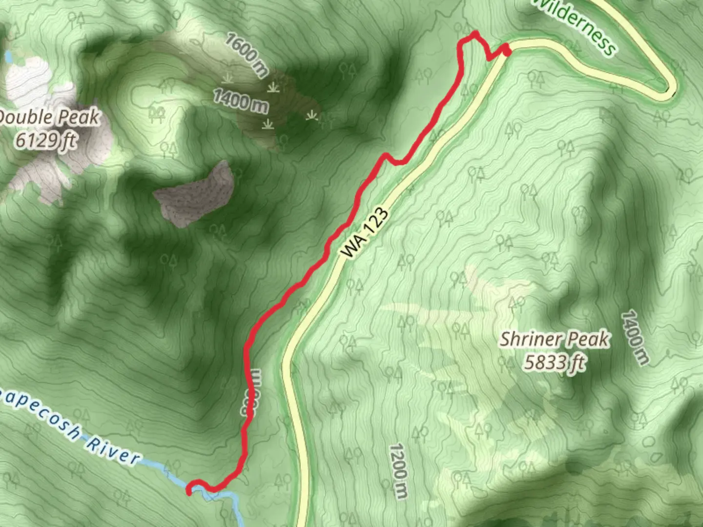
Starting your hike near Pierce County, Washington, the Ohanapecosh River via Owyhigh Lakes Trail offers a captivating journey through the lush landscapes of Mount Rainier National Park. This out-and-back trail spans approximately 10 kilometers (6.2 miles) with an elevation gain of around 400 meters (1,312 feet), making it a moderately challenging adventure suitable for hikers with some experience.### Getting There To reach the trailhead, you can drive or use public transportation. If driving, head towards the White River Entrance of Mount Rainier National Park. The nearest significant landmark is the White River Campground, which is well-signposted and offers parking facilities. For those using public transport, the closest major city is Seattle. From Seattle, you can take a bus or train to Enumclaw, and then a local shuttle service to the park entrance.### Trail Overview The trail begins with a gentle ascent through dense forests of Douglas fir and western hemlock. The initial 2 kilometers (1.2 miles) are relatively easy, allowing you to acclimate to the terrain. As you progress, the trail becomes steeper, gaining elevation more rapidly. Keep an eye out for the diverse flora, including vibrant wildflowers in the spring and summer months.### Significant Landmarks At around the 3-kilometer (1.9-mile) mark, you'll encounter the first significant landmark: the Owyhigh Lakes. These serene alpine lakes are a perfect spot for a short break. The lakes are surrounded by meadows that burst into color during the wildflower season, offering a picturesque setting for photography.Continuing on, the trail leads you through a series of switchbacks, gaining elevation steadily. At approximately 5 kilometers (3.1 miles), you'll reach the highest point of the trail, offering panoramic views of the surrounding peaks and valleys. This is an excellent spot to pause and take in the breathtaking scenery.### Wildlife and Nature The trail is home to a variety of wildlife, including black bears, deer, and numerous bird species. It's essential to carry bear spray and know how to use it, as bear sightings are not uncommon. The Ohanapecosh River, which you will eventually reach, is a haven for trout, and you might spot fish swimming in the clear waters.### Historical Significance The region holds historical significance as it was traditionally used by Native American tribes for hunting and gathering. The name "Ohanapecosh" itself is derived from a Native American word meaning "standing at the edge." The area was later explored by European settlers and has since become a popular destination for nature enthusiasts.### Navigation and Safety Given the moderate difficulty of the trail, it's advisable to use a reliable navigation tool like HiiKER to stay on track. The trail is well-marked, but weather conditions can change rapidly, so always check the forecast before heading out. Carry sufficient water, snacks, and a first-aid kit, and ensure you have appropriate clothing for changing weather conditions.The return journey follows the same path, allowing you to revisit the stunning landscapes and perhaps notice details you missed on the way up. The descent is generally easier, but take care on the steeper sections to avoid slipping.This trail offers a rewarding experience with its combination of natural beauty, wildlife, and historical significance, making it a must-visit for any hiking enthusiast exploring Mount Rainier National Park.

What to expect?
Activity types
Comments and Reviews
User comments, reviews and discussions about the Ohanapecosh River via Owyhigh Lakes Trail, Washington.
4.58
average rating out of 5
12 rating(s)