Download
Preview
Add to list
More
30.1 km
~6 hrs 22 min
212 m
Point-to-Point
“The 30-km Snoqualmie Valley Trail offers diverse landscapes, historic sites, and moderate challenges for fit hikers.”
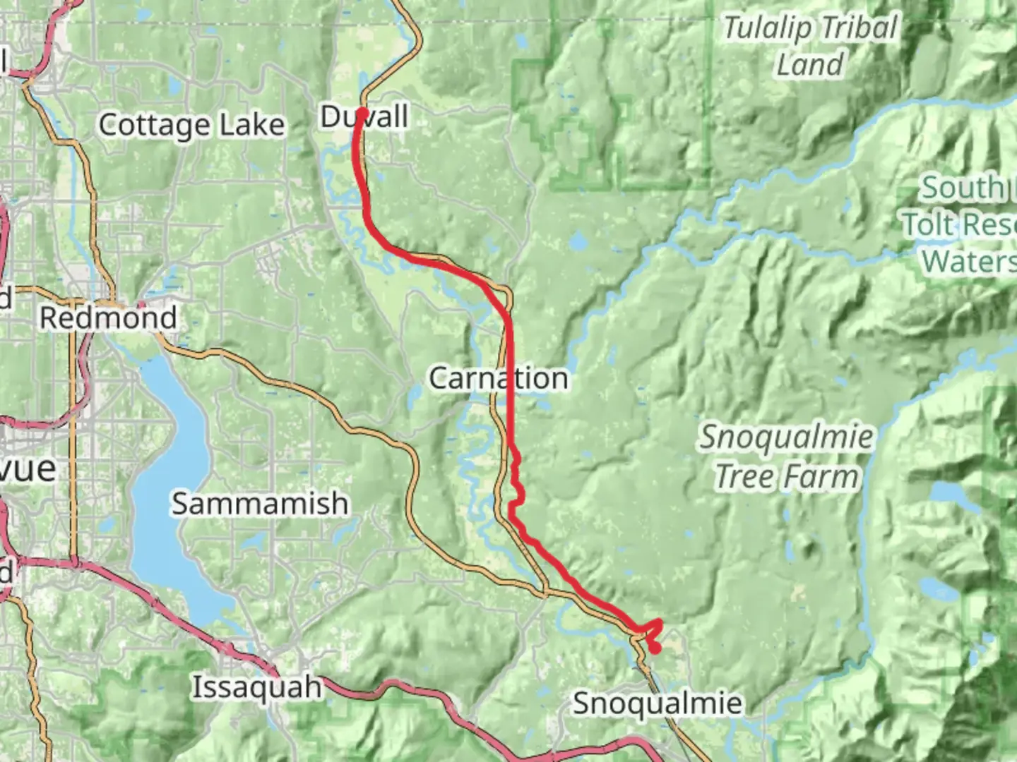
Starting near King County, Washington, the Snoqualmie Valley Trail stretches approximately 30 kilometers (around 18.6 miles) from Duvall to Snoqualmie. This point-to-point trail offers a moderate challenge with an elevation gain of about 200 meters (656 feet), making it suitable for hikers with a reasonable level of fitness.
Getting There
To reach the trailhead, you can drive or use public transportation. If driving, head towards Duvall, Washington, and look for parking near the Snoqualmie Valley Trailhead. For those using public transport, King County Metro Transit provides bus services to Duvall. From there, it's a short walk to the trail's starting point.
Trail Overview
The trail follows an old railroad grade, providing a relatively smooth and even path. It is well-maintained and marked, making navigation straightforward. For precise navigation, consider using the HiiKER app, which offers detailed maps and real-time updates.
Key Landmarks and Sections
Duvall to Carnation (0-10 km / 0-6.2 miles)
Starting in Duvall, the first section of the trail takes you through lush forests and alongside the Snoqualmie River. This part of the trail is relatively flat, making it a gentle introduction to the hike. Keep an eye out for local wildlife, including deer and various bird species. The town of Carnation, located about 10 kilometers (6.2 miles) in, offers a good spot for a rest or a quick snack.
Carnation to Fall City (10-20 km / 6.2-12.4 miles)
As you leave Carnation, the trail begins to gain elevation gradually. This section is known for its scenic views of the Cascade Mountains and the surrounding valley. You'll pass through open meadows and dense woodlands, providing a diverse hiking experience. Fall City, approximately 20 kilometers (12.4 miles) from the start, is another excellent place to take a break. Here, you can explore the historic downtown area, which dates back to the early 1900s.
Fall City to Snoqualmie (20-30 km / 12.4-18.6 miles)
The final stretch from Fall City to Snoqualmie includes the most significant elevation gain. The trail winds through more forested areas and offers stunning views of Mount Si and the Snoqualmie Falls. The falls are a major highlight, plunging 82 meters (268 feet) and providing a spectacular sight, especially during the rainy season. The trail ends in the town of Snoqualmie, known for its rich railroad history and the Northwest Railway Museum.
Historical Significance
The Snoqualmie Valley has a rich history, deeply rooted in the logging and railroad industries. The trail itself follows the path of the old Milwaukee Road railway, which was crucial for transporting timber and other goods in the early 20th century. Along the way, you'll find remnants of this history, including old trestles and railway artifacts.
Wildlife and Nature
The trail is a haven for wildlife enthusiasts. In addition to deer and birds, you might spot black bears, especially in the more remote sections. The diverse flora includes towering Douglas firs, western red cedars, and a variety of wildflowers, particularly vibrant in the spring and summer months.
Preparation Tips
Given the moderate difficulty, ensure you have sturdy hiking boots and sufficient water. Weather can be unpredictable, so pack layers and rain gear. The trail is multi-use, so be prepared to share it with cyclists and horseback riders.
For navigation, the HiiKER app is invaluable, providing detailed maps and real-time updates to keep you on track.

What to expect?
Activity types
Comments and Reviews
User comments, reviews and discussions about the Snoqualmie Valley Trail - Duvall to Snoqualmie, Washington.
4.4
average rating out of 5
10 rating(s)