Download
Preview
Add to list
More
15.0 km
~4 hrs 51 min
1115 m
Loop
“Embark on a rewarding 15 km hike with stunning vistas, historical intrigue, and vibrant wildlife near King County.”
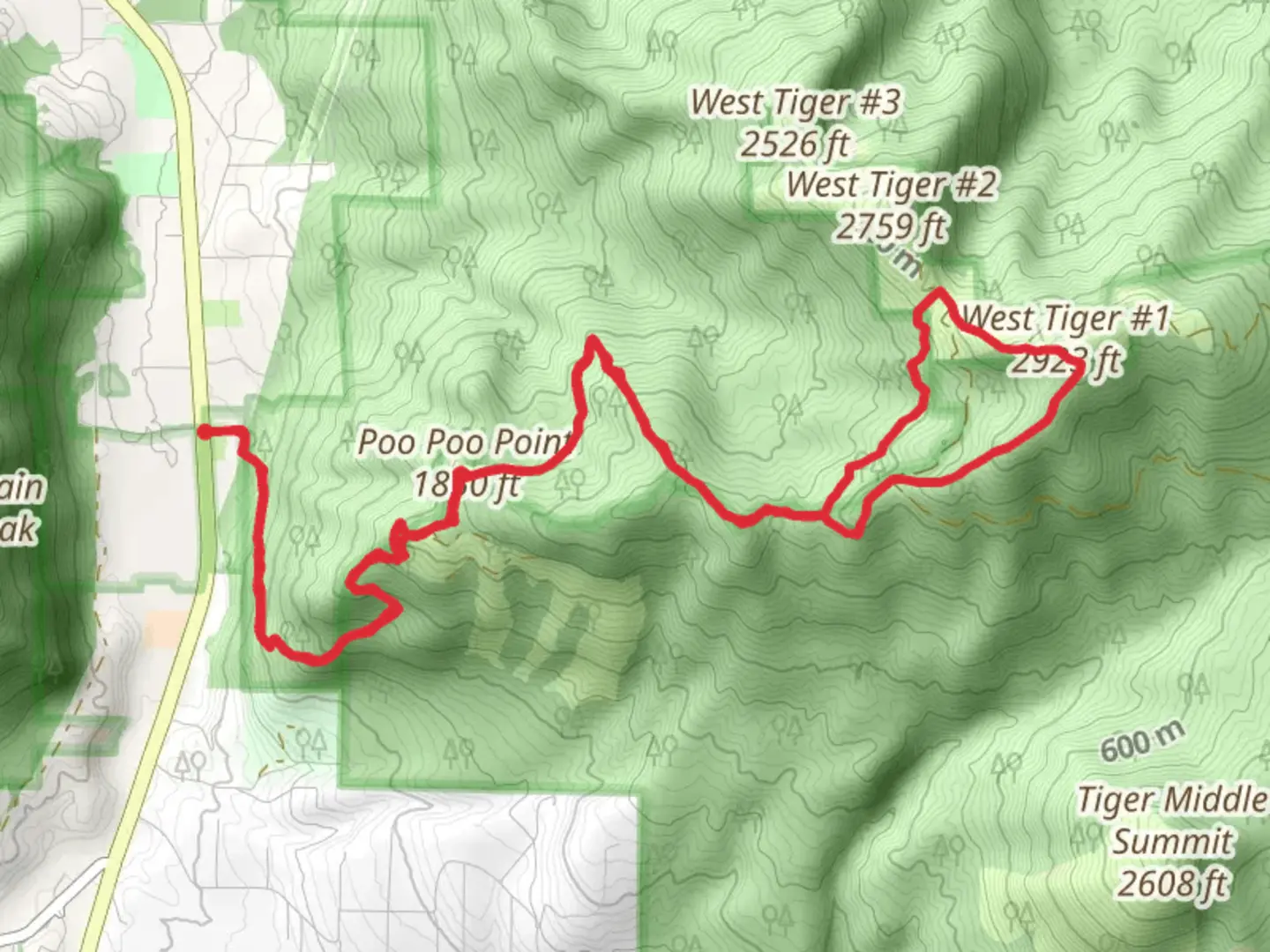
Starting near King County, Washington, the Poo-Poo Point and West Tiger 1 Loop Trail offers a challenging yet rewarding hiking experience. This 15 km (approximately 9.3 miles) loop trail features an elevation gain of around 1100 meters (3600 feet), making it a medium difficulty hike suitable for those with a moderate level of fitness.### Getting There To reach the trailhead, you can drive or use public transportation. If driving, head towards Issaquah, WA, and park at the Issaquah High School or the nearby Issaquah Alps Trailhead. For public transport, take a bus to Issaquah Transit Center, which is a short walk from the trailhead.### Trail Overview The trail begins with a steady ascent through dense forest, providing ample shade and a cool environment. Early on, you'll encounter a series of switchbacks that help manage the steep elevation gain. The first significant landmark is Poo-Poo Point, located about 4 km (2.5 miles) from the trailhead. This viewpoint offers stunning vistas of Lake Sammamish and the surrounding valleys. It's also a popular spot for paragliders, so you might see some taking off or landing.### Wildlife and Flora As you continue, the trail meanders through lush forests filled with Douglas fir, western hemlock, and red cedar. Keep an eye out for local wildlife such as black-tailed deer, black bears, and various bird species like the Pacific wren and the spotted towhee. The underbrush is rich with ferns, salal, and huckleberries, especially vibrant in the spring and summer months.### Historical Significance The area around Poo-Poo Point has historical significance tied to the logging industry. The name "Poo-Poo Point" is derived from the sound of steam whistles used by logging companies in the early 20th century. These whistles, or "poo-poos," were used to signal the movement of logs and machinery.### West Tiger 1 After leaving Poo-Poo Point, the trail continues to climb towards West Tiger 1, the highest point on the loop. This section is more strenuous, with steeper inclines and rocky terrain. At approximately 8 km (5 miles) into the hike, you'll reach the summit of West Tiger 1, which stands at an elevation of 915 meters (3002 feet). The summit offers panoramic views of the Cascade Range, Mount Rainier, and the Seattle skyline on clear days.### Descent and Return The descent from West Tiger 1 is gradual, taking you through more forested areas and eventually reconnecting with the initial trail. This part of the trail is less steep but can be slippery, especially after rain, so watch your footing. The loop brings you back to the trailhead, completing the 15 km journey.### Navigation For navigation, it's highly recommended to use HiiKER, which provides detailed maps and real-time updates on trail conditions. This will help you stay on track and ensure a safe and enjoyable hike.### Preparation Given the elevation gain and length of the trail, it's essential to bring plenty of water, snacks, and appropriate clothing. Weather can change rapidly, so layers are advisable. Hiking poles can also be beneficial for the steeper sections.This trail offers a mix of natural beauty, historical context, and physical challenge, making it a must-visit for hiking enthusiasts in the King County area.

What to expect?
Activity types
Comments and Reviews
User comments, reviews and discussions about the Poo-Poo Point and West Tiger 1 Loop Trail, Washington.
4.44
average rating out of 5
9 rating(s)