Download
Preview
Add to list
More
12.6 km
~4 hrs 28 min
1172 m
Out and Back
“The Mount Si Trail offers a rewarding 13-kilometer hike with stunning views and rich biodiversity.”
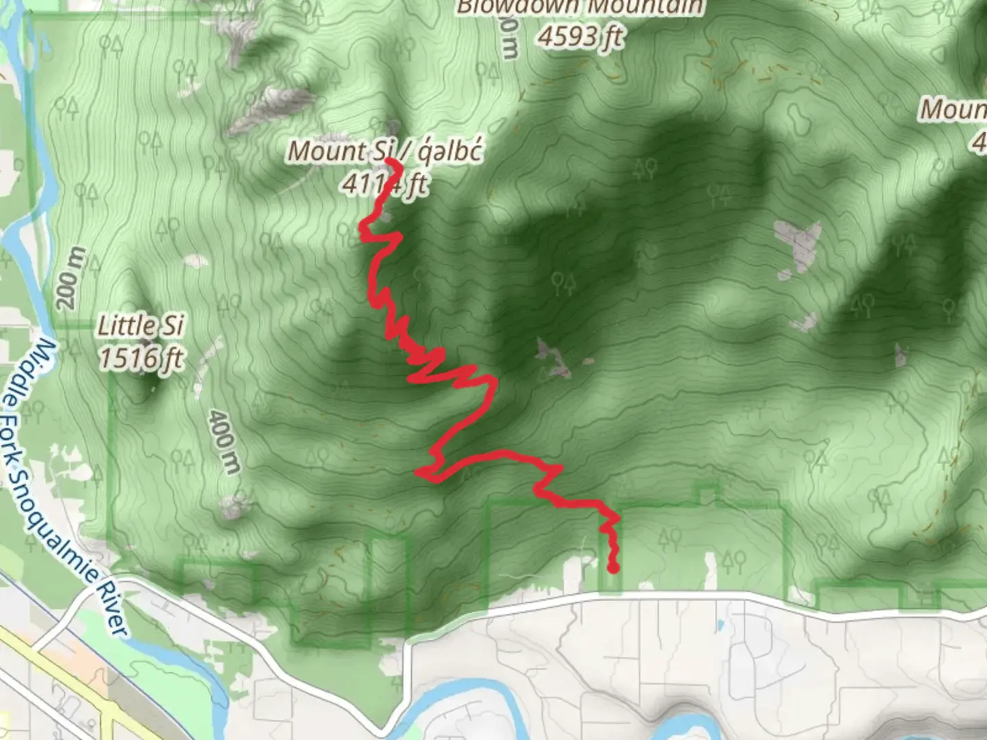
Starting near King County, Washington, the Mount Si Trail is a popular out-and-back hike that spans approximately 13 kilometers (8 miles) with an elevation gain of around 1,100 meters (3,600 feet). This trail is rated as medium difficulty, making it accessible for moderately experienced hikers.### Getting There To reach the trailhead, you can drive or use public transportation. If driving, head towards North Bend, Washington, and follow signs to the Mount Si Trailhead, located near the Little Si Trailhead parking lot. For those using public transport, King County Metro Transit offers bus services to North Bend, where you can then take a short taxi or rideshare to the trailhead.### Trail Overview The trail begins at the Mount Si Trailhead, which is well-marked and equipped with restrooms and informational boards. The first section of the trail is relatively gentle, winding through dense forest with a mix of Douglas fir, western hemlock, and cedar trees. This initial stretch is a good warm-up, covering about 1.6 kilometers (1 mile) with a modest elevation gain.### Ascent and Key Landmarks As you progress, the trail becomes steeper and rockier. Around the 3.2-kilometer (2-mile) mark, you'll encounter the Snag Flats, a flat area that offers a brief respite from the climb. This section is notable for its lush vegetation and occasional sightings of deer and various bird species.Continuing upward, the trail becomes more challenging, with switchbacks that help manage the steep ascent. At approximately 6.4 kilometers (4 miles) in, you'll reach the Haystack Basin. This area provides stunning views of the surrounding Cascade Range and is a popular spot for a rest before the final push to the summit.### The Summit The last section to the summit involves a scramble up the Haystack, a rocky outcrop that requires careful footing. While this part is optional, it offers panoramic views of the Snoqualmie Valley and, on clear days, the Seattle skyline. The summit is a rewarding endpoint, providing a 360-degree view that makes the effort worthwhile.### Flora and Fauna The Mount Si Trail is rich in biodiversity. In addition to the towering evergreens, you'll find a variety of wildflowers, especially in the spring and early summer. Wildlife is abundant, with frequent sightings of black-tailed deer, chipmunks, and a variety of bird species, including woodpeckers and owls.### Historical Significance Mount Si holds cultural significance for the Snoqualmie people, who consider it a sacred site. The mountain is named after Josiah "Uncle Si" Merritt, an early settler in the area. The trail itself has been a popular hiking destination since the early 20th century, attracting outdoor enthusiasts from all over the region.### Navigation For navigation, it is recommended to use the HiiKER app, which provides detailed maps and real-time updates. This will help you stay on track and ensure a safe and enjoyable hike.### Final Tips Be sure to bring plenty of water, snacks, and appropriate clothing, as weather conditions can change rapidly. Hiking poles can be helpful for the steeper sections, and sturdy footwear is essential. Always check trail conditions before heading out, especially during the winter months when snow and ice can make the trail more challenging.

What to expect?
Activity types
Comments and Reviews
User comments, reviews and discussions about the Mount Si Trail, Washington.
4.6
average rating out of 5
15 rating(s)