Download
Preview
Add to list
More
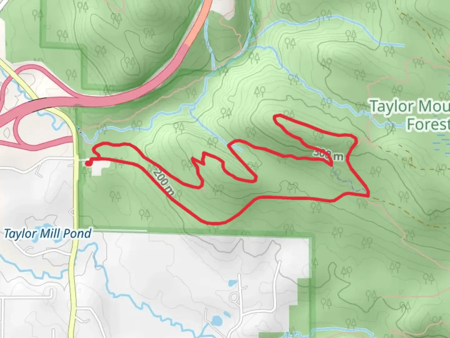
5.7 km
~1 hrs 32 min
248 m
Loop
“Explore lush forests, stunning vistas, and rich history on the 6 km Holder Ridge Trail Loop.”
Starting near King County, Washington, the Holder Ridge Trail and Road A Loop is a captivating 6 km (approximately 3.7 miles) loop with an elevation gain of around 200 meters (656 feet). This trail is rated as medium difficulty, making it suitable for moderately experienced hikers.
Getting There
To reach the trailhead, you can drive or use public transportation. If driving, head towards the nearest known landmark, the Preston Athletic Fields and Park, located at 30300 SE High Point Way, Preston, WA 98050. From there, it's a short drive to the trailhead. For those using public transport, take a bus to the Preston Park and Ride, which is conveniently located nearby. From the park and ride, you can either walk or arrange for a short taxi ride to the trailhead.
Trail Overview
The trail begins with a gentle ascent through a lush forest of Douglas firs and western hemlocks. The initial 1 km (0.6 miles) offers a relatively easy walk, allowing you to acclimate to the surroundings. As you progress, the trail becomes steeper, gaining about 100 meters (328 feet) in elevation over the next 1.5 km (0.9 miles). This section can be a bit challenging, so take your time and enjoy the serene environment.
Significant Landmarks and Nature
Around the 2.5 km (1.5 miles) mark, you'll come across a small clearing that offers a stunning view of the surrounding valleys and distant mountains. This is a great spot to take a break and snap some photos. Continuing on, the trail meanders through a series of switchbacks, gradually descending back towards the starting point.
Wildlife and Flora
The Holder Ridge Trail is home to a variety of wildlife, including deer, raccoons, and occasionally black bears. Birdwatchers will be delighted by the presence of woodpeckers, owls, and various songbirds. The flora is equally diverse, with seasonal wildflowers adding splashes of color to the verdant landscape.
Historical Significance
This region has a rich history, once inhabited by the Snoqualmie Tribe. The area was later developed for logging in the early 20th century, and remnants of old logging roads can still be seen along the trail. These historical elements add an intriguing layer to your hiking experience.
Navigation and Safety
For navigation, it's highly recommended to use the HiiKER app, which provides detailed maps and real-time updates. The trail is well-marked, but having a reliable navigation tool ensures you stay on track. Always carry enough water, wear sturdy hiking boots, and be prepared for sudden weather changes, as the Pacific Northwest is known for its unpredictable climate.
Completing the Loop
As you near the end of the loop, the trail flattens out, making for a pleasant and easy finish. The final 1 km (0.6 miles) takes you through a dense forest canopy, eventually leading you back to the trailhead. This section is particularly beautiful in the late afternoon when the sunlight filters through the trees, casting a golden glow on the forest floor.
By the time you complete the Holder Ridge Trail and Road A Loop, you'll have experienced a diverse range of landscapes, historical sites, and possibly some local wildlife, making it a rewarding hike for anyone looking to explore the natural beauty of King County, Washington.

What to expect?
Activity types
Comments and Reviews
User comments, reviews and discussions about the Holder Ridge Trail and Road A Loop, Washington.
4.55
average rating out of 5
11 rating(s)