Download
Preview
Add to list
More
5.0 km
~1 hrs 13 min
130 m
Loop
“Immerse yourself in the lush rainforests of Clallam County on this captivating 5-kilometer trail loop.”
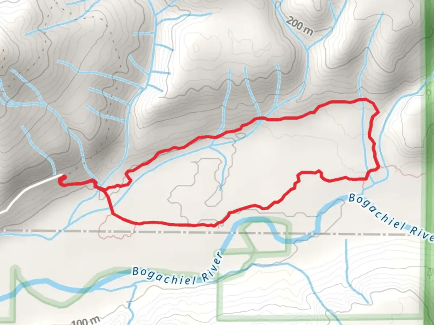
Starting your adventure near Clallam County, Washington, the Bogachiel Rain Forest Trail and Ira Spring Wetland Trail offer a captivating loop of around 5 kilometers (3.1 miles) with an elevation gain of approximately 100 meters (328 feet). This medium-difficulty trail is perfect for those looking to immerse themselves in the lush, temperate rainforests of the Pacific Northwest.
Getting There
To reach the trailhead, you can drive or use public transport. If driving, head towards the Bogachiel State Park, located off Highway 101. The nearest significant landmark is the town of Forks, Washington, which is about a 30-minute drive from the trailhead. For those using public transport, buses run from Port Angeles to Forks, where you can then take a taxi or rideshare to the trailhead.
Trail Navigation
For navigation, it’s highly recommended to use the HiiKER app, which provides detailed maps and real-time updates. The trail is well-marked, but having a reliable navigation tool will ensure you stay on course.
Trail Highlights
As you begin your hike, you'll be greeted by the dense canopy of the Bogachiel Rain Forest. This area is part of the larger Olympic National Park, known for its old-growth forests and diverse ecosystems. The first kilometer (0.6 miles) of the trail is relatively flat, making it an easy start as you acclimate to the surroundings.
Flora and Fauna
The trail is a haven for nature enthusiasts. You'll encounter towering Sitka spruce and western hemlock trees, some of which are centuries old. The forest floor is carpeted with ferns, mosses, and lichens, creating a vibrant green landscape. Keep an eye out for Roosevelt elk, black-tailed deer, and a variety of bird species, including the northern spotted owl and marbled murrelet.
Significant Landmarks
Around the 2-kilometer (1.2-mile) mark, you'll come across the Ira Spring Wetland. Named after the renowned conservationist and photographer Ira Spring, this wetland area is a crucial habitat for amphibians and waterfowl. The wetland is particularly beautiful in the spring and early summer when wildflowers are in bloom.
Elevation Gain
As you continue, the trail begins to ascend gently. The elevation gain is gradual, making it manageable for most hikers. By the time you reach the 3-kilometer (1.9-mile) point, you'll have climbed about 50 meters (164 feet). This section offers stunning views of the surrounding forest and occasional glimpses of the Bogachiel River.
Historical Significance
The Bogachiel Rain Forest is part of the traditional lands of the Quileute Tribe. The area has a rich cultural history, and you may come across interpretive signs that provide insights into the tribe's connection to the land. Respect the natural and cultural heritage by staying on designated trails and following Leave No Trace principles.
Final Stretch
The last 2 kilometers (1.2 miles) of the loop take you through a mix of dense forest and open wetland areas. The trail descends gradually, bringing you back to the trailhead. This section is particularly serene, offering a peaceful end to your hike.
Preparation Tips
- Wear sturdy hiking boots, as the trail can be muddy, especially after rain.
- Bring plenty of water and snacks.
- Pack a rain jacket, as the weather can be unpredictable.
- Use the HiiKER app for navigation and trail updates.
This trail offers a perfect blend of natural beauty, moderate challenge, and historical significance, making it a must-visit for any hiking enthusiast.

What to expect?
Activity types
Comments and Reviews
User comments, reviews and discussions about the Bogachiel Rain Forest Trail and Ira Spring Wetland Trail, Washington.
4.33
average rating out of 5
9 rating(s)