Download
Preview
Add to list
More
6.8 km
~2 hrs 26 min
655 m
Out and Back
“Malans Peak via Malans Basin Trail offers a scenic, moderately challenging 7 km hike with historical and panoramic rewards.”
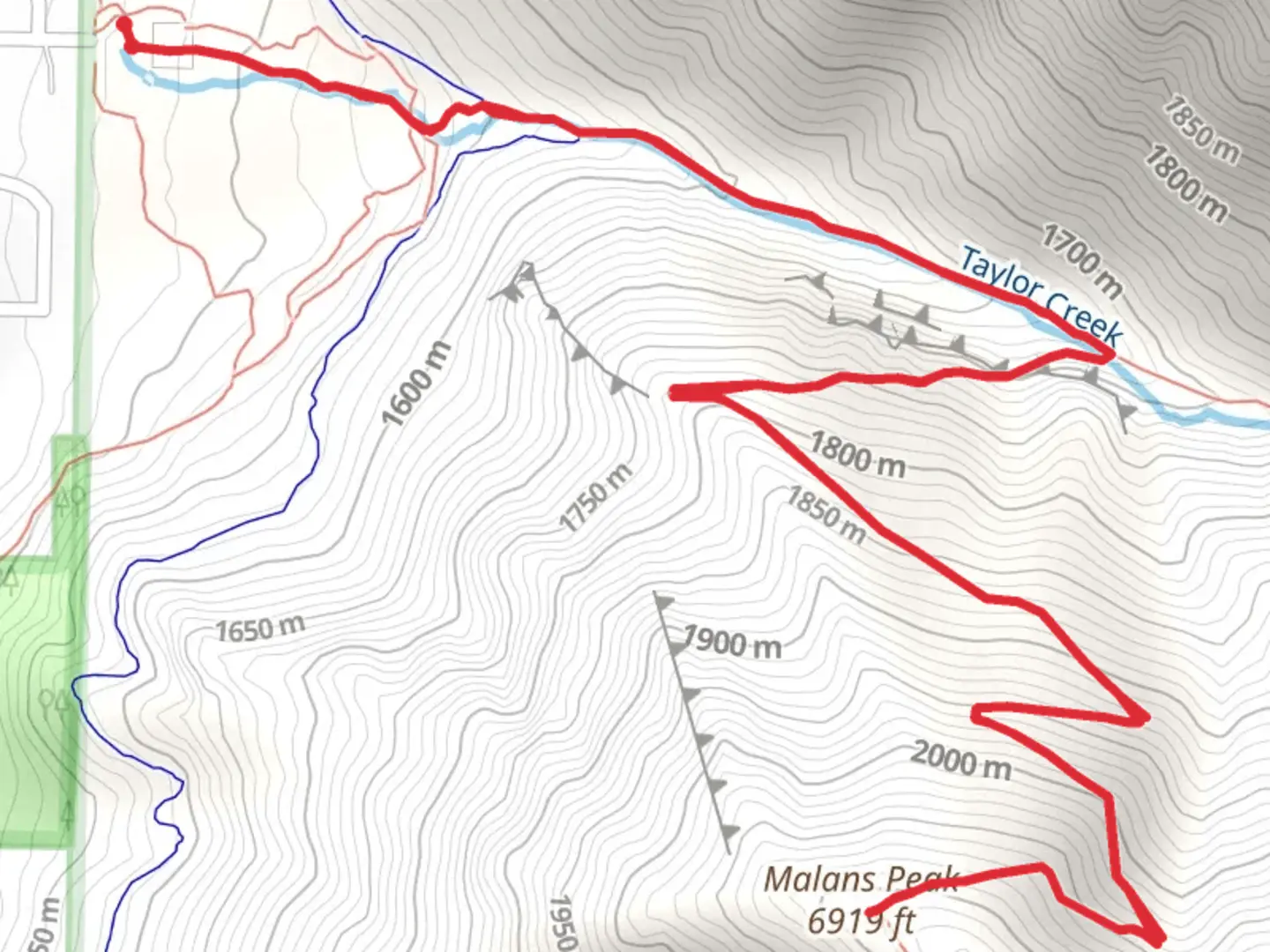
Starting your hike near Weber County, Utah, the Malans Peak via Malans Basin Trail offers a rewarding adventure with a total distance of around 7 km (4.3 miles) and an elevation gain of approximately 600 meters (1,968 feet). This out-and-back trail is rated as medium difficulty, making it suitable for moderately experienced hikers.
Getting There
To reach the trailhead, you can drive or use public transportation. If driving, head towards the 29th Street Trailhead, located at the end of 29th Street in Ogden, Utah. For those using public transport, take a bus to the nearest stop at Harrison Boulevard and 29th Street, and then walk east to the trailhead.
Trail Overview
The trail begins with a steady incline through a shaded forest area, providing a cool and refreshing start. As you ascend, you'll encounter a series of switchbacks that gradually increase in steepness. The first significant landmark is the Malans Basin, located about 2.5 km (1.5 miles) into the hike. This basin is a great spot to take a break and enjoy the serene surroundings.
Historical Significance
Malans Basin holds historical significance as it was once the site of a popular resort in the late 19th and early 20th centuries. The resort, established by the Malan family, featured a hotel and various recreational activities. Although the resort no longer exists, remnants of its foundations can still be seen, offering a glimpse into the area's past.
Wildlife and Nature
As you continue your ascent, the trail opens up to more exposed areas, offering panoramic views of the Ogden Valley and the Great Salt Lake. Keep an eye out for local wildlife, including deer, foxes, and a variety of bird species. The flora along the trail changes with elevation, transitioning from dense forest to alpine meadows.
Reaching Malans Peak
The final stretch to Malans Peak is the most challenging, with a steeper incline and rocky terrain. However, the effort is well worth it. Upon reaching the peak, you'll be rewarded with breathtaking views of the surrounding landscape, including the Wasatch Range and the city of Ogden below. The peak is an excellent spot for photography and a well-deserved rest before heading back down.
Navigation
For navigation, it's highly recommended to use the HiiKER app, which provides detailed maps and real-time updates to ensure you stay on the correct path. The trail is well-marked, but having a reliable navigation tool can enhance your hiking experience.
Return Journey
The descent follows the same path, allowing you to revisit the beautiful scenery from a different perspective. Take your time on the way down, as the rocky sections can be tricky. Ensure you have plenty of water and snacks, as the hike can take several hours to complete.
This trail offers a mix of natural beauty, historical intrigue, and physical challenge, making it a must-visit for hikers in the Weber County area.

What to expect?
Activity types
Comments and Reviews
User comments, reviews and discussions about the Malans Peak via Malans Basin Trail, Utah.
4.57
average rating out of 5
21 rating(s)