Download
3D Preview
Add to list
More
11.9 km
~2 hrs 28 min
60 m
Out and Back
“The White City Canal Trail offers a scenic, flat 12 km hike with historic landmarks and diverse landscapes.”
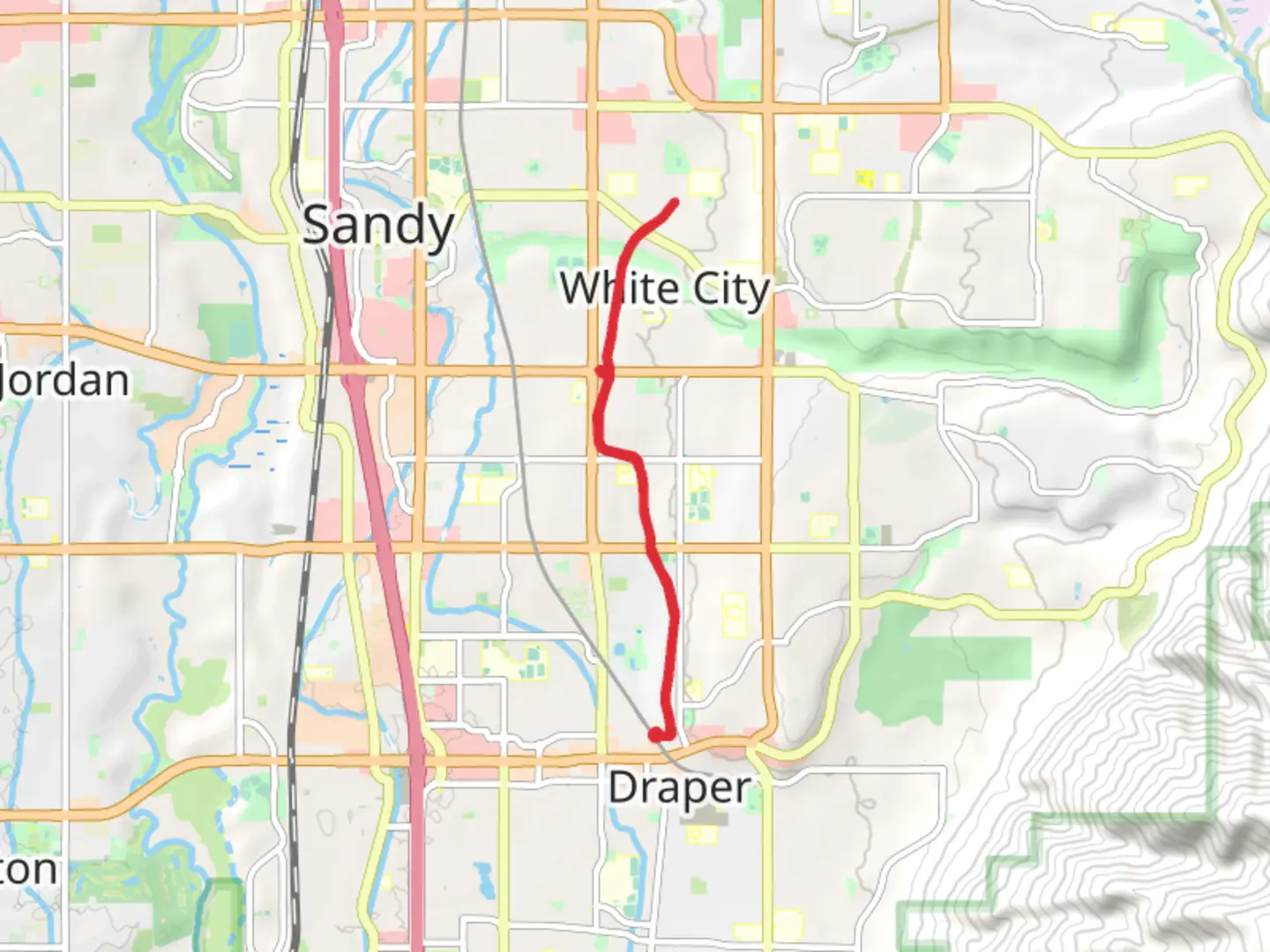
The White City Canal Trail is a scenic 12 km (7.5 miles) out-and-back trail located near Salt Lake County, Utah. With an elevation gain of around 0 meters (0 feet), this trail is relatively flat, making it accessible for hikers of varying skill levels, though it is rated as medium difficulty due to its length and some uneven terrain.
Getting There
To reach the trailhead, you can drive or use public transportation. If driving, head towards the nearest significant landmark, the White City Water Treatment Plant, located at 9999 S 700 E, Sandy, UT 84070. There is ample parking available near the plant. For those using public transport, take the UTA TRAX Blue Line to the Sandy Civic Center Station. From there, it's a short bus ride on Route 201 to the 9400 S @ 700 E stop, followed by a brief walk to the trailhead.
Trail Navigation
The trail is well-marked and follows the historic White City Canal, which was once a vital waterway for the region. For navigation, it's recommended to use the HiiKER app, which provides detailed maps and real-time updates.
What to Expect
The trail meanders through a mix of urban and natural landscapes, offering a unique blend of scenery. You'll start near the White City Water Treatment Plant and follow the canal, which is lined with mature trees providing ample shade. The first 2 km (1.2 miles) are relatively straightforward, with a gravel path that is easy to follow.
Landmarks and Points of Interest
Around the 3 km (1.9 miles) mark, you'll come across the historic White City Bridge, a relic from the early 20th century. This bridge offers a great spot for photos and a brief rest. Continuing along the trail, you'll pass through several small parks and green spaces, including the Lone Peak Park at approximately 5 km (3.1 miles). This park has restrooms, picnic tables, and a playground, making it a good spot for a break.
Flora and Fauna
The trail is home to a variety of wildlife, including birds such as hawks and songbirds. You might also spot small mammals like squirrels and rabbits. The flora is diverse, with native plants like sagebrush and wildflowers dotting the landscape, especially vibrant in the spring and early summer.
Historical Significance
The White City Canal itself is a significant historical feature. Constructed in the late 1800s, it played a crucial role in the irrigation and development of the Salt Lake Valley. As you hike, you'll notice remnants of old irrigation equipment and signage that provides historical context.
Final Stretch
The last 2 km (1.2 miles) of the trail take you through a more urban setting, eventually leading to the turnaround point near the intersection of 10600 S and 700 E. Here, you can either choose to head back the way you came or explore the nearby shops and cafes before returning.
Preparation Tips
Given the trail's length, it's advisable to bring plenty of water, snacks, and sun protection. The flat terrain makes it suitable for families and casual hikers, but the distance requires a moderate level of fitness. Always check the weather forecast before heading out and use the HiiKER app for the most accurate trail conditions and updates.

What to expect?
Activity types
Comments and Reviews
User comments, reviews and discussions about the White City Canal Trail, Utah.
4.56
average rating out of 5
9 rating(s)