Download
Preview
Add to list
More
27.8 km
~1 day 2 hrs
883 m
Out and Back
“Embark on a moderately challenging 28 km journey through Utah's Uinta Mountains to pristine Fox Lake.”
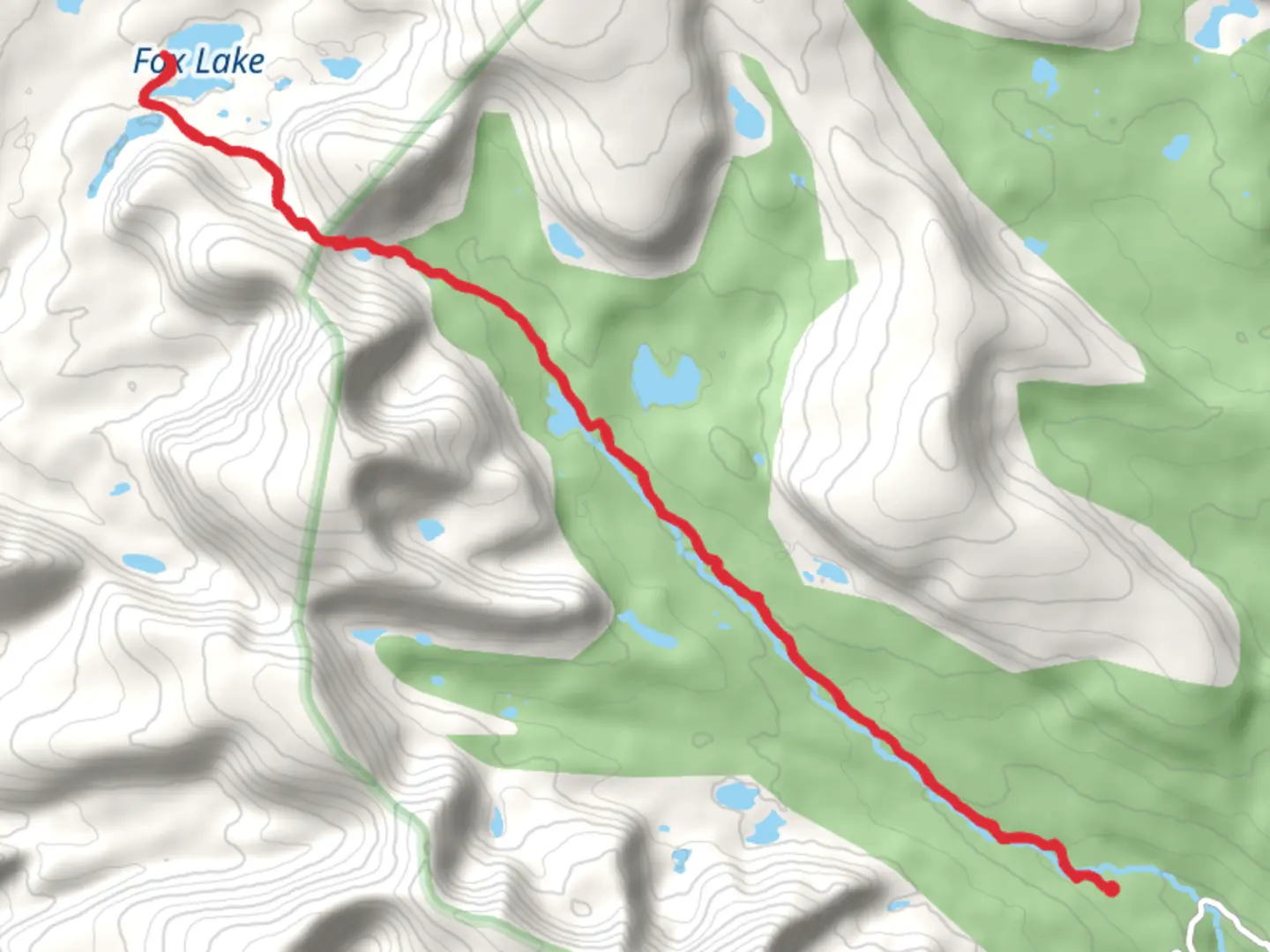
Starting your adventure near Duchesne County, Utah, the Fox Lake via West Fork Whiterocks Trail offers a captivating journey through the Uinta Mountains. This out-and-back trail spans approximately 28 kilometers (17.4 miles) with an elevation gain of around 800 meters (2,625 feet), making it a moderately challenging hike suitable for those with some experience.
Getting There To reach the trailhead, you can drive or use public transport. If driving, head towards the West Fork Whiterocks Trailhead, located near the town of Altonah, Utah. From Duchesne, take US-40 E and UT-87 N to Altonah, then follow local roads to the trailhead. Public transport options are limited, so driving is recommended.
Trail Overview The trail begins at the West Fork Whiterocks Trailhead, where you will immediately be greeted by the serene beauty of the Uinta Mountains. The initial section of the trail is relatively gentle, winding through dense forests of pine and aspen. As you progress, the trail gradually ascends, offering glimpses of the surrounding peaks and valleys.
Key Landmarks and Sections - **First 5 Kilometers (3.1 Miles):** The first part of the trail takes you through lush meadows and alongside the West Fork Whiterocks River. This section is relatively flat, with an elevation gain of about 150 meters (492 feet). Keep an eye out for deer and other wildlife that frequent the area. - **Midway Point (Around 14 Kilometers / 8.7 Miles):** As you approach the midway point, the trail becomes steeper and more rugged. Here, you will encounter a series of switchbacks that lead you up to higher elevations. The elevation gain in this section is approximately 400 meters (1,312 feet). The views become increasingly spectacular, with panoramic vistas of the Uinta Mountains.
- Approaching Fox Lake: The final stretch to Fox Lake is a rewarding climb. The trail levels out as you near the lake, with the last 2 kilometers (1.2 miles) being relatively flat. Fox Lake itself is a pristine alpine lake, surrounded by towering peaks and lush greenery. It's an ideal spot for a rest, picnic, or even a refreshing swim if the weather permits.
Nature and Wildlife The Uinta Mountains are home to a diverse range of flora and fauna. Along the trail, you may encounter mule deer, elk, and a variety of bird species. The forests are rich with pine, fir, and aspen trees, providing ample shade and a cool respite during the warmer months. Wildflowers are abundant in the summer, adding vibrant colors to the landscape.
Historical Significance The Uinta Mountains have a rich history, with evidence of Native American habitation dating back thousands of years. The area was also explored by early trappers and settlers in the 19th century. The trail itself follows routes that were likely used by these early inhabitants and explorers, adding a layer of historical intrigue to your hike.
Navigation and Safety Given the moderate difficulty of the trail, it's essential to be well-prepared. Ensure you have a reliable map and navigation tools; the HiiKER app is highly recommended for accurate trail information and real-time updates. Weather in the Uinta Mountains can be unpredictable, so pack accordingly with layers, rain gear, and sufficient food and water.
Embarking on the Fox Lake via West Fork Whiterocks Trail promises a memorable adventure filled with natural beauty, wildlife encounters, and a touch of historical significance. Whether you're seeking solitude or a challenging hike, this trail offers a bit of everything for the avid hiker.

What to expect?
Activity types
Comments and Reviews
User comments, reviews and discussions about the Fox Lake via West Fork Whiterocks Trail, Utah.
4.42
average rating out of 5
12 rating(s)