Download
Preview
Add to list
More
19.8 km
~5 hrs 33 min
952 m
Point-to-Point
“Explore the Palmetto Trail for panoramic views, rich biodiversity, and historical insights on a moderately challenging hike.”
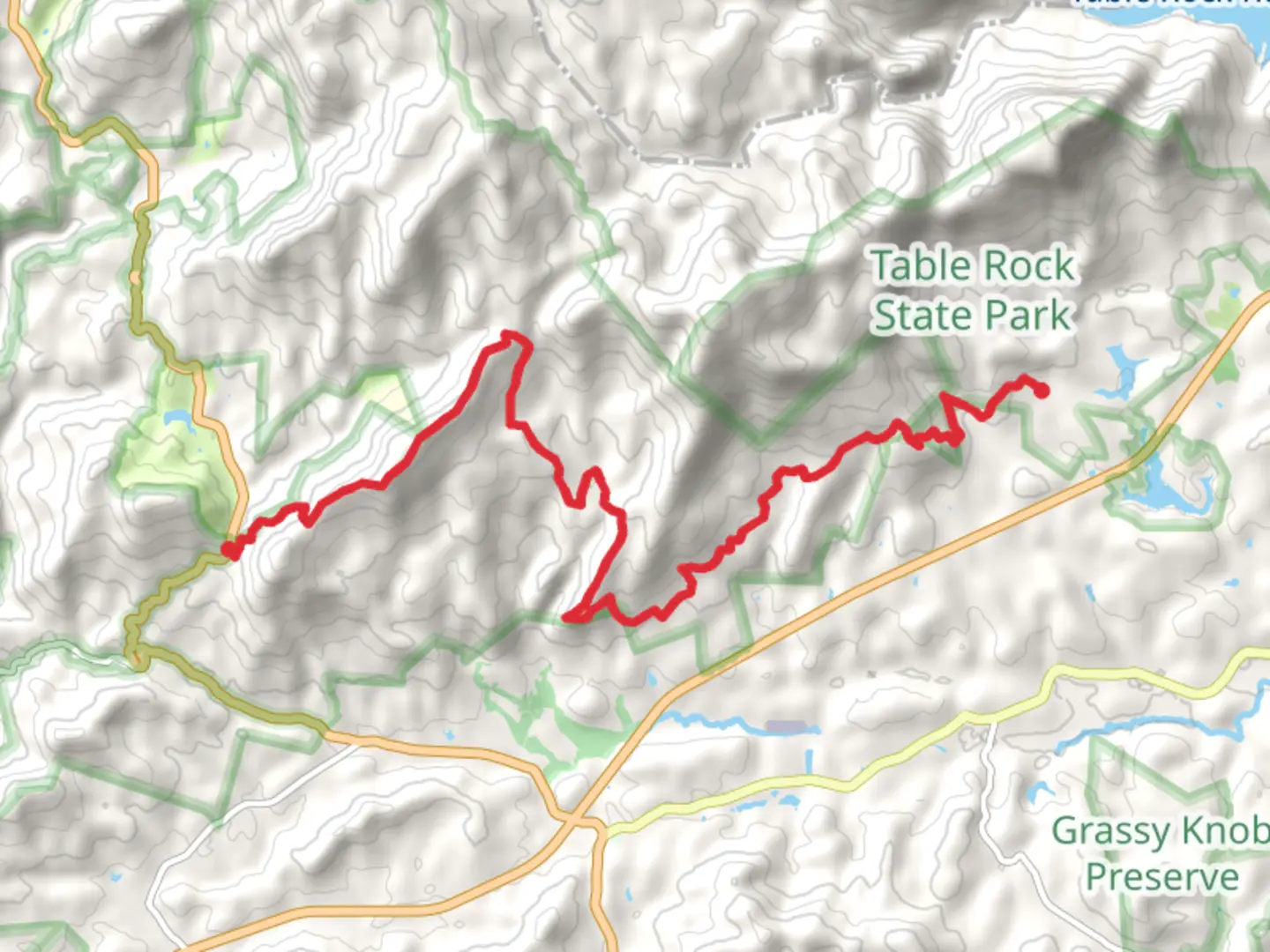
Starting near Pickens County, South Carolina, this 20 km (approximately 12.4 miles) point-to-point trail offers a moderately challenging hike with an elevation gain of around 900 meters (approximately 2,950 feet). The trailhead is accessible by car, with parking available near the entrance. For those relying on public transport, the nearest significant landmark is the town of Pickens, from where you can arrange a taxi or rideshare to the trailhead.
Trail Overview
The Palmetto Trail, Horse Gap, and Horse Mountain section is a diverse and scenic route that takes you through a variety of landscapes, including dense forests, open meadows, and rocky outcrops. The trail is well-marked, but it's advisable to use the HiiKER app for navigation to ensure you stay on track.
Key Landmarks and Sections
Horse Gap
Approximately 5 km (3.1 miles) into the hike, you'll reach Horse Gap. This section is characterized by a noticeable elevation gain, with the trail climbing steadily through a mixed hardwood forest. Keep an eye out for white-tailed deer and wild turkeys, which are commonly spotted in this area. The forest canopy provides ample shade, making this section a bit cooler and more comfortable, especially during the warmer months.
Horse Mountain
Around the 10 km (6.2 miles) mark, you'll begin the ascent of Horse Mountain. This is the most challenging part of the hike, with a steep climb that rewards you with panoramic views of the surrounding landscape. The summit offers a great spot for a break and some photography. On clear days, you can see as far as the Blue Ridge Mountains. The elevation gain here is significant, so take your time and stay hydrated.
Flora and Fauna
The trail is rich in biodiversity. In the spring and summer, you'll find a variety of wildflowers, including mountain laurel and rhododendron. Birdwatchers will appreciate the abundance of species, from songbirds to birds of prey. The area is also home to black bears, so it's essential to follow proper bear safety guidelines.
Historical Significance
This region has a rich history, with the trail passing through areas that were once inhabited by the Cherokee people. Keep an eye out for historical markers and informational plaques that provide insights into the cultural heritage of the area. The trail also intersects with old logging roads and remnants of early 20th-century homesteads, offering a glimpse into the past.
Practical Information
- Water Sources: There are a few natural water sources along the trail, but it's advisable to carry enough water for the entire hike or bring a water filtration system.
- Camping: There are designated camping areas along the trail for those who wish to turn this into a multi-day hike. Check local regulations and obtain any necessary permits.
- Weather: The weather can change rapidly, especially at higher elevations. Be prepared for sudden rain showers and cooler temperatures at the summit.
Getting There
If driving, set your GPS to Pickens County, South Carolina, and follow the signs to the trailhead. For public transport users, take a bus or train to Pickens and then arrange for a taxi or rideshare to the trailhead. The nearest significant landmark for navigation purposes is the town of Pickens.
This trail offers a rewarding experience for those prepared for a moderately challenging hike, with stunning views, rich biodiversity, and a touch of historical intrigue.

What to expect?
Activity types
Comments and Reviews
User comments, reviews and discussions about the Palmetto Trail, Horse Gap and Horse Mountain, South Carolina.
4.48
average rating out of 5
73 rating(s)