Download
3D Preview
Add to list
More
5.0 km
~1 hrs 5 min
49 m
Point-to-Point
“Shaded Yellow Creek singletrack rolls through leafy woods, with roots and junctions keeping it lively.”
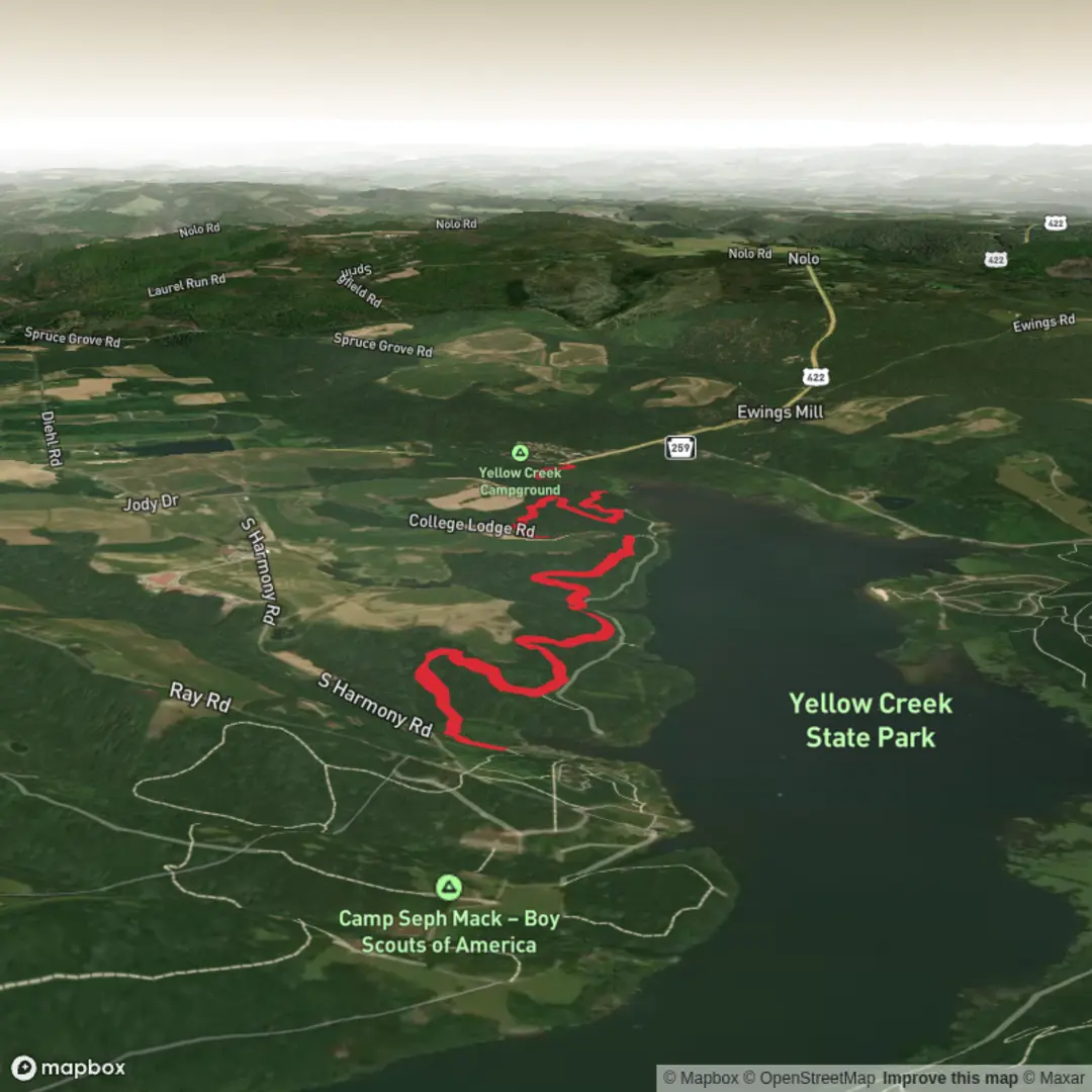
You’ll find this route in Yellow Creek State Park in Indiana County, Pennsylvania, on the northeast side of Yellow Creek Lake. For planning purposes, the closest “known address” to use for the trailhead area is the park office:
Yellow Creek State Park (Park Office), 170 Route 259 Highway, Penn Run, PA 15765. (pa.gov)
Getting to the start (car + public transport reality check)
By car: From Indiana, PA, you’ll generally approach via US-422 and then connect to PA-259 following signs for Yellow Creek State Park. The park office address above will reliably get you into the park, and from there you can use the park map/trail signage to reach the correct trail access. (pa.gov)
By public transport: There isn’t a straightforward bus/train stop at the park itself. The practical approach is to take intercity service into Indiana, PA (or another nearby town) and then use a rideshare/taxi for the last stretch to the park office area. Plan for limited cell service in the park and download what you need ahead of time. (pa.gov)
This trail is commonly mapped as about 5.5 km (3.4 mi) with roughly 67 m (219 ft) of climbing—very close to your “around 5 km / 100 m” estimate, but expect the elevation gain to feel modest and spread out rather than one big sustained climb. (mtbproject.com)
You’ll be moving through mixed woodland typical of western Pennsylvania state-park terrain—leafy canopy, shaded tread, and short punchy rises and dips. The trail is officially part of a larger multi-use network around the lake, so it’s normal to encounter other users and junctions. (lhorba.org)
On the trail: what the 5–6 km feels like
From the signed access point, the tread quickly settles into singletrack character—narrow, winding, and generally well-defined. Over the first 1 km / 0.6 mi, expect gentle undulation as the trail threads through the forest, with small grade changes that add up gradually rather than spiking your heart rate. (mtbproject.com)
Between roughly 1 km and 3.5 km (0.6–2.2 mi), the trail tends to deliver its “personality”: a sequence of short climbs and descents that keep your footing engaged. Even though the overall route can be approached as easy at hiking pace, watch for roots, embedded rocks, and occasional tighter turns—features that are more noticeable after rain or during leaf-fall when the tread can be camouflaged. (mtbproject.com)
The final 2 km / 1.2 mi typically continues the rolling profile toward the far end of the segment (often described as running between two mapped points on the park system). If you’re trying to keep the outing close to 5 km / 3.1 mi, this is a good place to plan a turnaround at a clear junction or landmark rather than pushing to the next connector. (mtbproject.com)
Navigation + junction management (use HiiKER)
This park has multiple named trails and connectors, so the main skill here is junction discipline: pause at intersections, confirm the trail name, and don’t assume the “most worn” line is yours (multi-use traffic can make side lines look tempting). Use HiiKER to: - confirm you’re on the correct segment when the singletrack braids or widens, - mark your intended turnaround/junction, - and keep an eye on how close you are to other loop options around the lake. (lhorba.org)
Seasonal considerations + what to look out for
Yellow Creek State Park is open year-round (day use sunrise to sunset), but conditions change a lot by season. (pa.gov)
- Wet weather: Expect slick roots and soft spots; traction becomes the main limiter, not fitness.
- Hunting seasons: The park allows hunting, and users may encounter hunting activity in fall and spring turkey season—wear bright colors and consider avoiding peak

Surfaces
Dirt
Unknown
Comments and Reviews
User comments, reviews and discussions about the Handlers Long Haul Trail, Pennsylvania.
average rating out of 5
0 rating(s)