Download
3D Flyover
Add to list
More
5.6 km
~1 hrs 16 min
98 m
Loop
“Drift through South Limburg’s hedged fields and cool woods, with gentle rises and muddy surprises.”
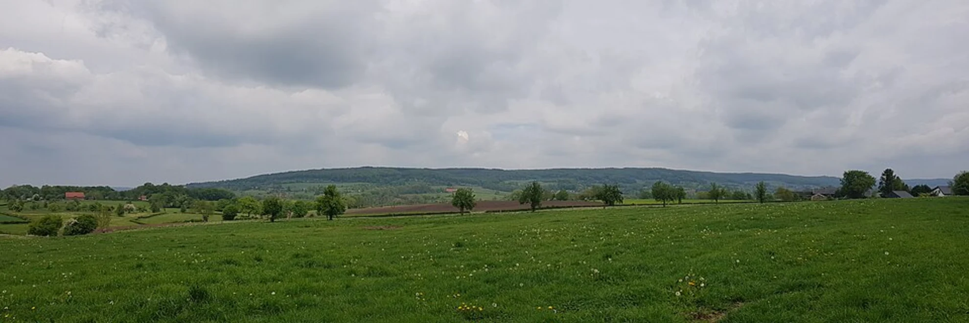
A gentle countryside-and-woodland loop of about 6 km (3.7 mi) with roughly 100 m (330 ft) of climbing, this walk strings together open fields, hedgerows, and a compact patch of forest typical of South Limburg’s rolling “heuvelland.” Expect a mix of quiet farm lanes, grassy/packed paths, and short woodland tracks—ideal for a relaxed half-day outing, but with enough little ups and downs to notice.
Getting to the start (car + public transport)
Because the start point is listed only as “near” (no coordinates or town provided), the most reliable way to pin down the exact trailhead is to open the route in HiiKER and use its start-point map pin. If you share the lon/lat (or a HiiKER link), I can convert it to the nearest known address or landmark and tailor the directions precisely.
By car (typical approach for this area): - Aim for the Epen area in South Limburg (near the Dutch–Belgian border). Epen is the most likely hub given the route name. - Parking is usually easiest at signed village car parks or near sports fields/community facilities; from there, you can walk to the loop’s start if it begins on the village edge.
By public transport (typical approach): - The region is commonly reached by bus connections from Heerlen / Maastricht / Vaals / Gulpen toward Epen. From the nearest stop, you’ll usually have a short walk through the village to reach the first path or lane. - Use HiiKER to confirm the start pin, then match it to the closest bus stop for the shortest walk-in.
What the route feels like underfoot
Over 6 km (3.7 mi), the ~100 m (330 ft) of ascent is spread out in small rises rather than one big climb. You’ll likely notice: - Gently rolling gradients on field-edge paths and farm access lanes. - Short, slightly steeper pitches where the route transitions between valley-bottom lanes and higher pasture edges. - Woodland footing in Holsetterbosch: leaf litter, roots, and occasional muddy patches after rain.
Even on an “Easy” loop, bring footwear with decent tread—South Limburg clay can get slick, especially where tractors have churned the margins.
The first third: lanes, hedgerows, and open views
Early on, you typically move through a patchwork of pasture and arable fields divided by hedges and tree lines. These hedgerows are more than scenery: - They act as wildlife corridors—watch for small birds flitting between shrubs and the quick, low flight of pheasants. - In spring and summer, field edges can be rich with wildflowers and pollinators; in late summer, expect tall grasses leaning into the path.
You’ll likely cross or follow quiet rural roads briefly. Stay alert for the occasional fast-moving local car or farm vehicle, especially on blind bends between high hedges.
Middle section: Holsetterbosch woodland character
Holsetterbosch is the loop’s “cooler, shadier” centerpiece. The feel changes quickly: - Light drops, the air can be noticeably damper, and the ground becomes softer. - Paths may narrow, with roots and small ruts—easy walking, but watch ankles if you’re chatting and not looking down. - After wet weather, expect muddy hollows and slippery leaf cover; take your time on any short descents.
Wildlife is often more noticeable here than in open fields: - Woodpeckers (listen for tapping), songbirds, and the occasional rustle of small mammals in undergrowth. - Deer are possible in the broader region, though sightings depend on time of day and how busy the woods are.
If you’re navigating, keep HiiKER handy through the woodland: junctions can come quickly, and leaf cover can obscure the “most-walked” line.
Final third: back to farmland and the South Limburg landscape
Leaving the trees, the route usually returns to open, undulating farmland. This is where the “heuvelland” identity stands out—rounded hills, scattered farmsteads, and long sightlines when hedges dip. You may pass: - Traditional farm buildings and pasture gates (leave gates as you find them). - Field-edge tracks where the surface alternates between firm and soft depending on recent farm activity.
Because this is an agricultural area, expect: - Electric fencing in grazing fields (usually well-marked). - Livestock (often cattle or sheep). Give animals space, keep voices calm, and don’t feed them. - Seasonal mud and manure on lanes—common and normal; just plan for shoes to get dirty.
Landmarks, culture, and historical context
This corner of South Limburg sits in a landscape shaped by centuries of farming and by its position near the Dutch–Belgian border. The region’s villages and field patterns reflect long-term rural land use, and the mix of lanes, hedges, and small woods is characteristic of traditional European agricultural mosaics. You may also notice architectural cues typical of the area—older farmsteads and village buildings that hint at the region’s cross-border cultural influences.
Practical planning: timing, kit, and conditions
- Time on trail: Most hikers will take 1.5–2 hours for 6 km (3.7 mi) at an easy pace, longer if you stop for photos or birdwatching.
- Footwear: Trail shoes are fine in dry spells; choose water-resistant hikers after

Surfaces
Unknown
Ground
Gravel
Sand
Grass
Comments and Reviews
User comments, reviews and discussions about the Epenerbaan and Holsetterbosch Loop, Netherlands.
average rating out of 5
0 rating(s)