Download
3D Flyover
Add to list
More
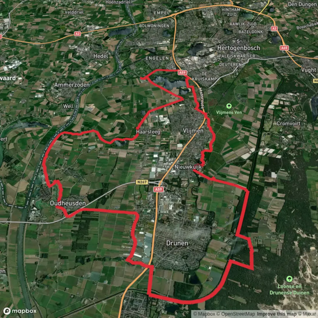
42.2 km
~2 days
0 m
Point-to-Point
“A ribbon-flat, all-day wander through lanes and field edges—where grit, foot care, and sharp navigation shine.”
This is a long, low-relief loop of roughly 42 km (26.1 mi) with essentially 0 m (0 ft) of sustained climbing, so the challenge is less about hills and more about time on feet, foot care, and staying oriented through a patchwork of paths, lanes, and field-edge tracks. Plan on a full day out: most hikers take 8–11 hours depending on pace, breaks, and how soft the ground is.
Because your start point is listed only as “near” (with no coordinates), I can’t reliably convert the start lon/lat to a nearest address or landmark yet. If you paste the start coordinate (or a GPX link), I’ll translate it to the closest named place/road/parking area and tailor the access directions precisely.
Getting to the start (car + public transport)
Without the exact start landmark, the best way to plan is to aim for the nearest village/town served by regional buses and a rail station within a short taxi/bus connection, then finish the last leg on foot or by local bus. For a loop of this length, it’s also common to: - Arrive by car and park at a signed trailhead lot or public parking near a church, sports club, or village green (typical in rural Benelux trail networks). - Arrive by public transport to the nearest rail station, then use a regional bus to a stop close to the trail network; from there, walk 0.5–2 km (0.3–1.2 mi) to the start.
If you share the nearest town name (or coordinates), I’ll give you a concrete plan with the closest parking option and the best bus/rail stop to target.
What the terrain feels like over 42 km
Expect a flat, fast-moving route where surfaces change frequently: - Paved farm lanes and quiet roads (easy footing, but repetitive impact on joints) - Gravel and compacted paths (generally the most comfortable for long distance) - Field-edge tracks and grassy verges (can be muddy, rutted, or overgrown in places) - Occasional short sandy or soft sections if the loop crosses heath/forest edges
Even with minimal elevation gain, this distance can sneak up on people. The main physical risks are blisters, hot spots, and tendon/IT-band irritation from steady, unbroken walking. Lightweight trail shoes are usually fine in dry conditions; after rain, consider footwear with better mud performance and bring a spare pair of socks.
Navigation and wayfinding (keep it simple)
On flat trail networks, the most common mistake is drifting onto the “right-looking” track that runs parallel to the correct one. Use HiiKER to: - Download the route for offline use before you leave coverage - Watch for micro-turns at field corners, drainage ditches, and T-junctions - Confirm you’re on the correct side of canals/ditches—many paths mirror each other
If the loop uses multiple named segments (Meerheuvelpad, Limietpad, Heusdenseweg), pay attention at the transitions: that’s where signage can change style or direction logic.
Landmarks, landscape character, and what to look for
This kind of long, flat loop typically threads through a mosaic landscape—small woodlots, hedgerows, drainage lines, and open agricultural fields—so the “high points” are often cultural and ecological details rather than viewpoints.
Look out for: - Boundary features suggested by names like Limietpad (“limit/boundary path”): old parish/municipal borders, straight property lines, and long, ruler-straight tracks that historically marked divisions between landholdings. - Farmsteads and field patterns: older farms often sit on slightly raised ground (subtle, but noticeable in wetter seasons), with ditches and culverts controlling water. - Quiet road crossings: you may cross a handful of faster rural roads—these are usually the most hazardous moments of the day, especially when you’re tired late in the hike.
If the route passes near any chapels, wayside crosses, small bridges, or historic lanes, they’re worth a short pause—these features often predate modern road layouts and hint at older travel corridors.
Nature and wildlife (seasonal expectations)
In lowland farmland/wood-edge terrain, wildlife is often heard before it’s seen: - Birdlife: skylarks and meadow birds in open fields; woodpeckers and songbirds near tree lines; waterfowl along ditches and ponds. - Mammals: rabbits and hares in field margins; roe deer are possible at dawn/dusk near woodland edges. - Insects: in warm months, expect mosquitoes/gnats near standing water and shaded lanes—pack repellent if you’re sensitive.
If the loop includes heath, scrub, or sandy forest edges, you may also see more butterflies and dragonflies in summer, especially near wet hollows.
Practical planning: time, water, food, and bailouts
For 42 km (26.1 mi) on mostly flat ground: - Water: plan for 2–3 L total capacity, topping up in villages/cafés if available. In rural stretches, taps can be scarce—don’t assume you’ll find one. - Food: bring enough for a full day (roughly 2,000–3,500 calories depending on your size and pace). Flat routes encourage steady movement—snack early and often. - Break strategy

Surfaces
Asphalt
Unknown
Unpaved
Dirt
Grass
Ground
Comments and Reviews
User comments, reviews and discussions about the Meerheuvelpad, Limietpad and Heusdenseweg Loop, Netherlands.
average rating out of 5
0 rating(s)