Download
3D Flyover
Add to list
More
21.8 km
~4 hrs 24 min
26 m
Loop
“Wander beneath ancient trees and alongside shimmering wetlands where history, wildlife, and Dutch ingenuity entwine.”
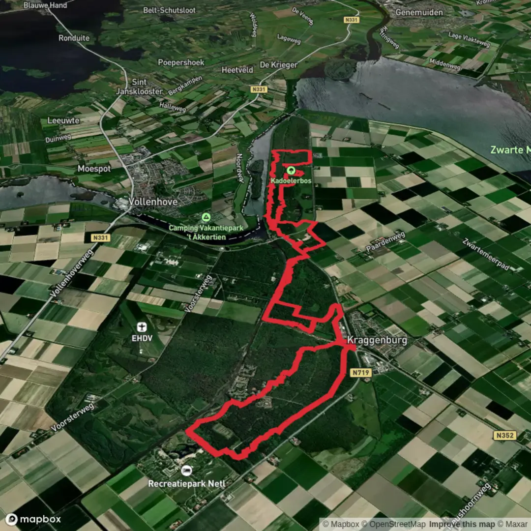
Starting from the edge of Kraggenburg, a small village in the province of Flevoland, the Voorsterbos and Kadoelerbos Loop offers a flat, easy-going circuit of approximately 22 km (about 13.7 miles) with virtually no elevation gain, making it accessible for hikers of all levels. The trailhead is conveniently located near the intersection of Voorsterweg and Kadoelerweg, just north of Kraggenburg, and is easily accessible by car with ample parking available at the Voorsterbos visitor center. For those using public transport, buses from Emmeloord or Zwolle stop at Kraggenburg, from where it’s a short walk to the starting point.
Navigating the Route
The loop is well-marked, but for added confidence and route planning, HiiKER provides detailed maps and GPS navigation. The path meanders through two distinct forests—Voorsterbos and Kadoelerbos—both part of the Noordoostpolder, a region reclaimed from the sea in the mid-20th century. Expect wide, well-maintained forest tracks and occasional paved sections, suitable for both walking and cycling.
Natural Highlights and Wildlife
The Voorsterbos is one of the oldest forests in Flevoland, planted after the land was reclaimed from the Zuiderzee. Mature beech, oak, and pine trees line the broad avenues, and in spring, carpets of wildflowers and ferns cover the forest floor. The area is rich in birdlife; look out for woodpeckers, buzzards, and the occasional tawny owl. Deer and foxes are sometimes spotted in the quieter stretches, especially early in the morning.
Transitioning into the Kadoelerbos, the landscape opens up with more wetlands and reed beds, providing habitat for herons, storks, and a variety of waterfowl. The air is often filled with birdsong, and the tranquil ponds attract dragonflies and butterflies in summer.
Landmarks and Points of Interest
- Waterloopbos (approx. 5 km/3.1 miles in): A unique open-air laboratory where hydraulic models of rivers and harbors were tested. The remnants of these concrete structures are now overgrown and form a fascinating, almost surreal landscape. Information panels explain the history and significance of the site.
- Kadoelermeer (approx. 13 km/8 miles in): A scenic lake and wetland area, perfect for a picnic stop. There are bird hides for those interested in wildlife observation.
- Historic Dikes and Canals: The route follows sections of the original dikes and drainage canals that made the Noordoostpolder possible. These engineering feats are a testament to Dutch ingenuity in water management.
Historical Significance
The Noordoostpolder, including Voorsterbos and Kadoelerbos, was reclaimed from the sea in the 1940s as part of the Zuiderzee Works, one of the largest land reclamation projects in history. The forests were planted to stabilize the new land and provide timber, but today they are valued for recreation and biodiversity. The Waterloopbos, now a national monument, played a crucial role in the development of Dutch and international water engineering.
Planning and Preparation
With a total distance of 22 km (13.7 miles) and no significant elevation changes, the loop can be completed comfortably in 5–6 hours at a moderate pace. There are several rest areas and picnic spots along the way, but facilities are limited, so bring sufficient water and snacks. The trail is open year-round, though waterproof footwear is recommended in wetter months due to occasional muddy patches, especially in Kadoelerbos.
Dogs are allowed on leash, and cyclists share some sections of the route. For navigation, download the route on HiiKER to ensure you stay on track and make the most of the points of interest along the way.

Surfaces
Unknown
Ground
Concrete
Dirt
Asphalt
Gravel
Grass
Paved
Wood
Comments and Reviews
User comments, reviews and discussions about the Voorsterbos and Kadoelerbos Loop, Netherlands.
average rating out of 5
0 rating(s)