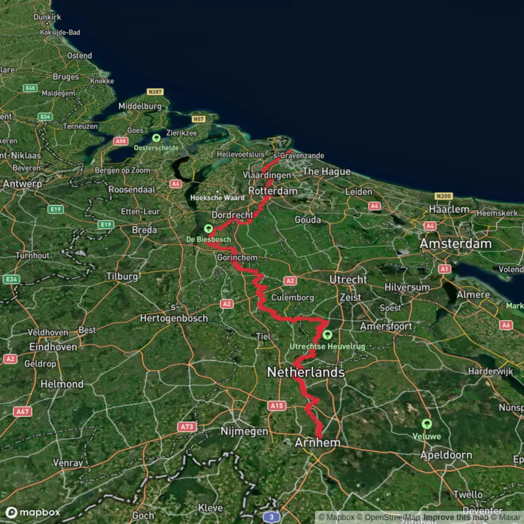
Arnhem to Hoek van Holland Strand via Bosweg, Peilmolenweg and Maassluissedijk
Download
Preview
Add to list
More
240.3 km
~9 days
316 m
Multi-Day
“From Arnhem’s wooded Rhine to Hoek van Holland’s surf, dikes and windmills test resolve.”
This is a long, low-relief traverse across the Netherlands from the wooded Rhine corridor at Arnhem to the North Sea at Hoek van Holland, stitched together by quiet lanes and dike-top roads—Bosweg, Peilmolenweg, and Maassluissedijk among them. Over roughly 240 km / 149 mi with only about 300 m / 985 ft of total ascent, the challenge is less about climbing and more about distance, wind exposure, hard surfaces, and staying oriented through a dense patchwork of towns, waterways, and agricultural polders.
Start location (nearest known landmark/address): a practical start point is Arnhem Centraal railway station, Stationsplein 166, 6811 KJ Arnhem. (maps.apple.com)
Finish location (nearest known landmark): Hoek van Holland Strand metro station by the beach area at Hoek van Holland. (en.wikipedia.org)
Getting to the start (public transport or car)
- Public transport: Arnhem is a major rail hub; the simplest meet-up point is Arnhem Centraal (Stationsplein 166), with frequent national connections and local buses/trolleybuses from the station area. (maps.apple.com)
- By car: aim for central Arnhem parking near the station district, then begin on foot from the station plaza. (If you’re planning multi-day logistics, it’s often easier to arrive by train and finish at the coast, rather than leaving a car at the start.)
What the terrain feels like day to day
Expect flat-to-gently rolling walking with long stretches at or below sea level once you leave the Arnhem region and enter the river-and-polder landscape of South Holland. Underfoot, much of this kind of route is typically paved cycleway, brick lane, compacted dike path, and farm access road—great for steady mileage, but it can be tough on feet over many consecutive days. Plan footwear and socks for repetitive impact rather than steep gradients.
Because the elevation gain is modest (~300 m / 985 ft total), the “difficulty” comes from: - wind (especially near open polders and the Nieuwe Waterweg corridor), - exposure (few natural windbreaks on dikes), - navigation through built-up edges of towns, and - crossings/bridges/ferries that can add detours if you miss the intended line.
For navigation, load the full line into HiiKER and keep an eye on “micro-decisions” at every dike junction, canal crossing, and urban greenway split—this is where flat-country routes most often go wrong.
Key waypoints and landmarks you’ll pass (and what to look for)
Arnhem and the Lower Rhine (early stage, roughly first 10–30 km / 6–19 mi depending on your exact line)
Arnhem sits on the Rhine system (Nederrijn/Lower Rhine) and is closely tied to major WWII history. The area around Arnhem became internationally known during Operation Market Garden (September 1944) and the Battle of Arnhem (17–26 September 1944), fought over control of Rhine crossings and approaches into Germany. Even if your route doesn’t detour to specific memorial sites, you’re walking through a landscape where bridges, riverbanks, and transport corridors were strategic objectives. (britannica.com)
Polder country and windmills near Oud-Alblas (mid-route highlight)
As you angle into South Holland’s polder mosaic, the route’s character shifts to canals, drainage ditches, and long sightlines. A standout landmark on your named roads is Peilmolenweg in Oud-Alblas, where the historic Peilmolen windmill sits at Peilmolenweg 1. This is classic Dutch water-management heritage: windmills like this were integral to pumping and regulating water levels in reclaimed land. (simav.nl

Surfaces
Asphalt
Unknown
Concrete
Grass
Cobblestone
Paved
Sand
Wood
Dirt
Comments and Reviews
User comments, reviews and discussions about the Arnhem to Hoek van Holland Strand via Bosweg, Peilmolenweg and Maassluissedijk, Netherlands.
average rating out of 5
0 rating(s)