Download
3D Flyover
Add to list
More
120.1 km
~4 days
26 m
Multi-Day
“From Arnhem’s Rhine echoes to Asten’s Peel fringes—flat, wind-tested days on dikes and lanes.”
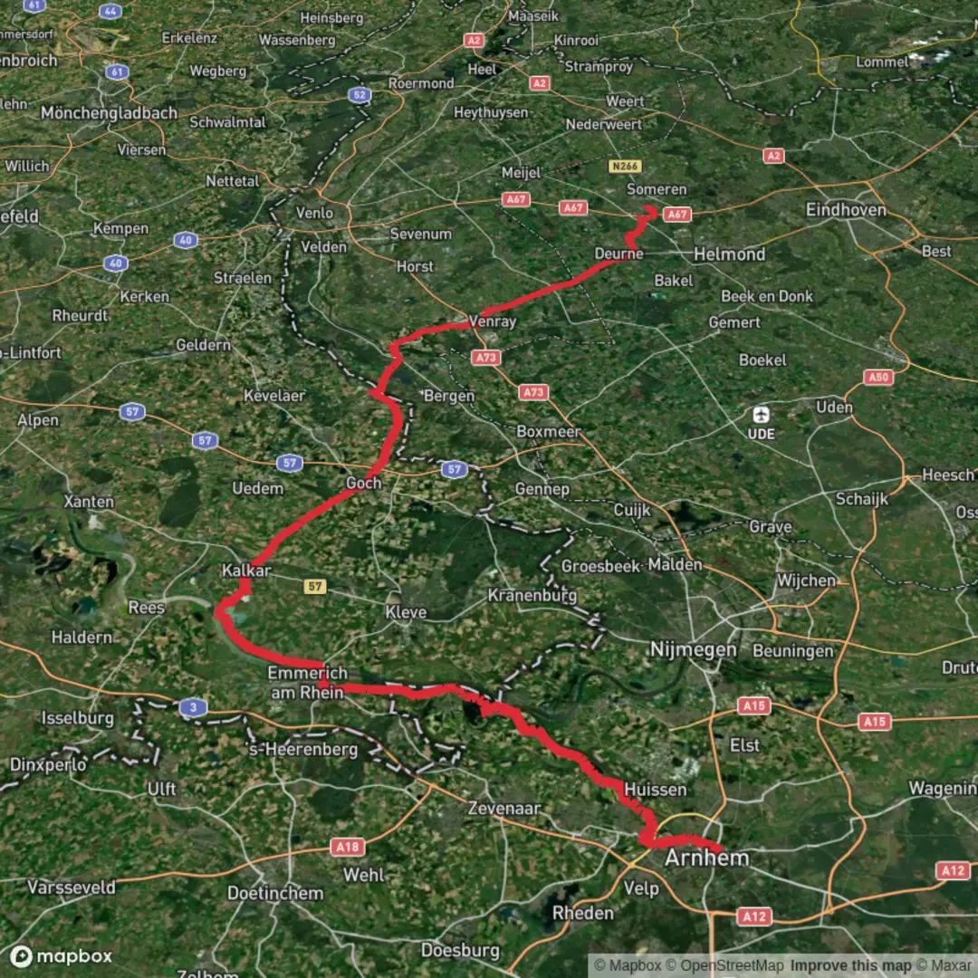
This is a long, low-lying point-to-point walk across the eastern and central Netherlands, linking the Rhine-side city of Arnhem with the Peel-region town of Asten. At roughly 120 km / 75 mi with about 0 m / 0 ft of total climbing, the challenge is less about hills and more about surface variety (pavement, farm tracks, canal paths), wind exposure, and managing long distances day after day. Plan on 3–5 days for most hikers (about 24–40 km / 15–25 mi per day), depending on daylight, accommodation spacing, and how much time you want for stops.
Getting to the start (Arnhem area)
By train/public transport:
Arnhem is one of the easiest Dutch cities to reach by rail. Intercity and regional trains connect Arnhem with major hubs (e.g., Utrecht, Amsterdam, Nijmegen). From Arnhem Centraal, you can walk or take a short local bus ride toward the likely trailhead area near the Rhine and city-edge green corridors.
By car:
Arnhem is well connected via the A12 and A50 motorways. Use city parking (P+R options are common) if you’re not being dropped off. For a point-to-point hike, many hikers either:
- park at the finish (Asten) and take public transport back to Arnhem, or
- arrive by train and avoid car logistics entirely.
Nearest well-known start landmark (for “near …”):
With the start listed only as “near” (no coordinates provided), the most practical, universally recognizable anchor is Arnhem Centraal Station (Stationsplein area) or the Rhine riverfront near John Frost Bridge (a major landmark and common walking corridor). If you share a lon/lat pin, it can be translated to the nearest street address or landmark precisely.
What the route feels like underfoot
Expect a predominantly flat, lowland traverse: urban edges out of Arnhem, then a long sequence of dike-top paths, polder lanes, farm roads, and village connectors. “Kleine Pley,” “Bijlandseweg,” and “Wezerweg” read like local road/track names you’ll encounter as you stitch together quiet countryside segments—often straight, often open, and sometimes surprisingly exposed to weather.
- Surfaces: a mix of asphalt cycle lanes, brick village streets, compacted gravel, and occasional muddy farm-track sections after rain.
- Navigation: the Netherlands is generally well signposted, but long-distance linking routes can involve frequent turns at junctions. Load the full line in HiiKER and keep an eye on small deviations where local roads braid together.
- Wind & weather: with minimal elevation change, wind becomes the “terrain.” A headwind across open fields can feel like climbing all day. Waterproof layers matter even on “easy” profiles.
Suggested staging (approximate)
Because the exact line can vary depending on how those named roads connect, treat these as planning ranges rather than exact stage endpoints:
Day 1: Arnhem to the river/dike villages — ~25–35 km / 16–22 mi, 0–20 m / 0–65 ft gain
You’ll likely transition from city parks and suburban edges into river landscapes and agricultural flats.Day 2: Dikes, polders, and village chains — ~25–35 km / 16–22 mi, 0–20 m / 0–65 ft gain
Long straightaways, canals, and field margins. This is where pacing and foot care matter most.Day 3: Toward the Peel fringe and Asten — ~25–40 km / 16–25 mi, 0–20 m / 0–65 ft gain
The landscape often becomes a touch more wooded and heath-like as you approach the Peel region, with more nature reserves and sandy soils in places.
If you prefer a 4–5 day itinerary, split the middle into shorter days to reduce repetitive strain and to better match lodging availability.
Landmarks, landscape, and nature to watch for
Arnhem & the Rhine corridor
Arnhem sits near the Rhine’s distributaries and floodplain systems. Early on, you may pass:
- River dikes and floodplain meadows (seasonally wet, big skies, wide views)
- Historic bridges and river crossings that have shaped trade and conflict routes for centuries
Agricultural heartland
Much of the middle distance is classic Dutch countryside:
- Polders and drainage canals: straight watercourses, pumping infrastructure, and reed-lined banks
- Farmsteads and field mosaics: dairy pasture, arable plots, and hedgerows
- Birdlife: expect abundant geese, swans, herons, coots, and in open fields lapwings and other waders depending on season. Early mornings are best for wildlife movement.
Peel region influence near Asten
Asten lies near the De Groote Peel landscape zone (peatland/heath remnants and nature reserves in the broader area). Even if your exact line doesn’t enter the core reserve, you may notice:
- more heath-like vegetation, pine plantations, and sandy tracks in places
- wetter pockets and drainage ditches that hint at the region’s peat history
Historical significance along the way
- Arnhem and WWII (Operation Market Garden, September 1944): Arnhem is internationally known for the Battle of Arnhem and the attempt to secure bridges over the Rhine. If your route passes near the **John

Surfaces
Asphalt
Unknown
Concrete
Paved
Dirt
Cobblestone
Unpaved
Grass
Comments and Reviews
User comments, reviews and discussions about the Arnhem to Asten via Kleine Pley, Bijlandseweg and Wezerweg, Netherlands.
average rating out of 5
0 rating(s)