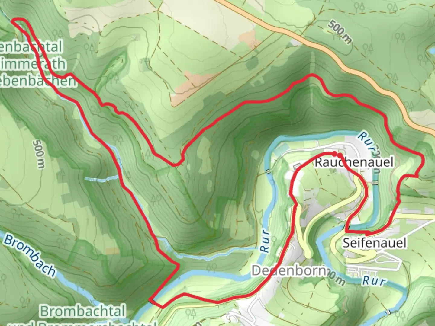
Tiefenbachtal bei Simmerath mit Nebenbächen Loop - Rauchenauel
Download
Preview
Add to list
More
8.1 km
~2 hrs 7 min
297 m
Loop
“Explore the Tiefenbachtal Loop: 8km of lush forests, historical intrigue, and moderate hiking challenges.”
Starting near Städteregion Aachen, Germany, the Tiefenbachtal bei Simmerath mit Nebenbächen Loop - Rauchenauel is an 8 km (approximately 5 miles) loop trail with an elevation gain of around 200 meters (656 feet). This medium-difficulty trail offers a delightful mix of natural beauty, historical significance, and moderate physical challenge.### Getting There To reach the trailhead, you can drive or use public transport. If driving, head towards Simmerath in the Städteregion Aachen. The nearest significant landmark is the town of Simmerath itself, which is well-signposted. For those using public transport, take a bus or train to Simmerath, and from there, you can either walk or take a local taxi to the trailhead.### Trail Overview The trail begins with a gentle ascent through lush forests, offering a serene start to your hike. The initial 2 km (1.2 miles) are relatively easy, with a gradual elevation gain of about 50 meters (164 feet). This section is perfect for warming up and getting accustomed to the terrain.### Significant Landmarks and Nature As you progress, you'll encounter the Tiefenbach stream, a picturesque waterway that adds a soothing soundtrack to your hike. Around the 3 km (1.9 miles) mark, you'll reach a small wooden bridge that crosses the stream. This is a great spot for a short break and some photos.Continuing on, the trail becomes more challenging, with a steeper ascent over the next 2 km (1.2 miles). You'll gain approximately 100 meters (328 feet) in elevation during this stretch. The effort is well worth it, as you'll be rewarded with stunning views of the surrounding valleys and forests.### Historical Significance The region around Simmerath has a rich history, dating back to Roman times. Keep an eye out for old stone markers and remnants of ancient pathways, which hint at the area's historical significance. The trail itself passes through areas that were once used for logging and agriculture, offering a glimpse into the region's past.### Wildlife and Flora The Tiefenbachtal area is home to a variety of wildlife, including deer, foxes, and numerous bird species. The forests are predominantly composed of beech and oak trees, providing ample shade and a vibrant green canopy during the warmer months. In spring and early summer, the forest floor is carpeted with wildflowers, adding bursts of color to your hike.### Navigation and Safety Given the moderate difficulty of the trail, it's advisable to use a reliable navigation tool like HiiKER to ensure you stay on track. The trail is well-marked, but having a digital map can provide extra peace of mind. Wear sturdy hiking boots, as some sections can be slippery, especially after rain.### Final Stretch The final 3 km (1.9 miles) of the loop are a gentle descent back towards the trailhead. This section offers a relaxing end to your hike, with more opportunities to enjoy the tranquil forest and perhaps spot some wildlife. The total elevation loss mirrors the gain, making for a balanced and enjoyable loop.This trail offers a perfect blend of natural beauty, moderate physical challenge, and historical intrigue, making it a rewarding experience for hikers of all levels.

What to expect?
Activity types
Comments and Reviews
User comments, reviews and discussions about the Tiefenbachtal bei Simmerath mit Nebenbächen Loop - Rauchenauel, Germany.
4.8
average rating out of 5
5 rating(s)