Download
Preview
Add to list
More
10.4 km
~2 hrs 35 min
302 m
Point-to-Point
“This 10 km German trail offers stunning views, historical landmarks, and diverse landscapes for adventurous hikers.”
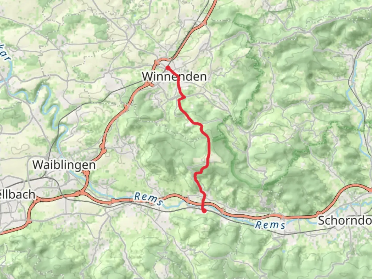
Starting near Rems-Murr-Kreis in Germany, this point-to-point trail stretches approximately 10 km (6.2 miles) with an elevation gain of around 300 meters (984 feet). The trailhead is conveniently accessible by public transport or car. If you're taking public transport, you can reach the starting point by taking a train to Winnenden station, which is well-connected to Stuttgart and other major cities. From there, it's a short walk to the trailhead. If you're driving, there are parking facilities available near the station.
Initial Ascent and Forested Paths
The hike begins with a gentle ascent through a mix of open fields and forested areas. The initial climb is gradual, making it a good warm-up for the more challenging sections ahead. As you move through the forest, keep an eye out for local wildlife such as deer and various bird species. The dense canopy provides ample shade, making this part of the trail particularly pleasant during warmer months.
Midway Point: Scenic Views and Historical Landmarks
Around the 5 km (3.1 miles) mark, you'll reach a series of clearings that offer stunning panoramic views of the surrounding countryside. This is a great spot to take a break and enjoy the scenery. The elevation gain here is about 150 meters (492 feet) from the start, so you'll have a good vantage point.
As you continue, you'll come across several historical landmarks. One notable site is the ruins of an old watchtower, which dates back to the medieval period. This area was historically significant as a lookout point to protect the region from invaders. The remnants of the tower provide a fascinating glimpse into the past and are worth a short detour.
Final Stretch: Descent into Grunbach
The last 3 km (1.9 miles) of the trail involve a descent into the town of Grunbach. This section is a bit steeper, so be prepared for a more challenging downhill trek. The path winds through vineyards and orchards, offering a different but equally beautiful landscape compared to the forested areas earlier in the hike.
As you approach Grunbach, the trail levels out, making for a pleasant end to your journey. Grunbach itself is a charming town with several cafes and restaurants where you can relax and refuel. The town is also well-connected by public transport, making it easy to return to your starting point or continue your journey elsewhere.
Navigation and Safety
For navigation, it's highly recommended to use HiiKER, which provides detailed maps and real-time updates. The trail is well-marked, but having a reliable navigation tool can help you stay on track and avoid any potential detours.
Flora and Fauna
Throughout the hike, you'll encounter a variety of flora and fauna. The forested sections are home to oak, beech, and pine trees, while the open fields and vineyards feature wildflowers and cultivated crops. Wildlife is abundant, with opportunities to see deer, foxes, and a variety of bird species, including hawks and woodpeckers.
Getting There
To reach the trailhead, take a train to Winnenden station if you're using public transport. The station is well-connected to Stuttgart and other major cities, making it a convenient starting point. If you're driving, there are parking facilities available near the station.
This trail offers a mix of natural beauty, historical landmarks, and moderate physical challenge, making it a rewarding experience for hikers of all levels.

What to expect?
Activity types
Comments and Reviews
User comments, reviews and discussions about the Winnenden to Grunbach Walk, Germany.
4.0
average rating out of 5
1 rating(s)