Download
Preview
Add to list
More
6.9 km
~1 hrs 48 min
252 m
Loop
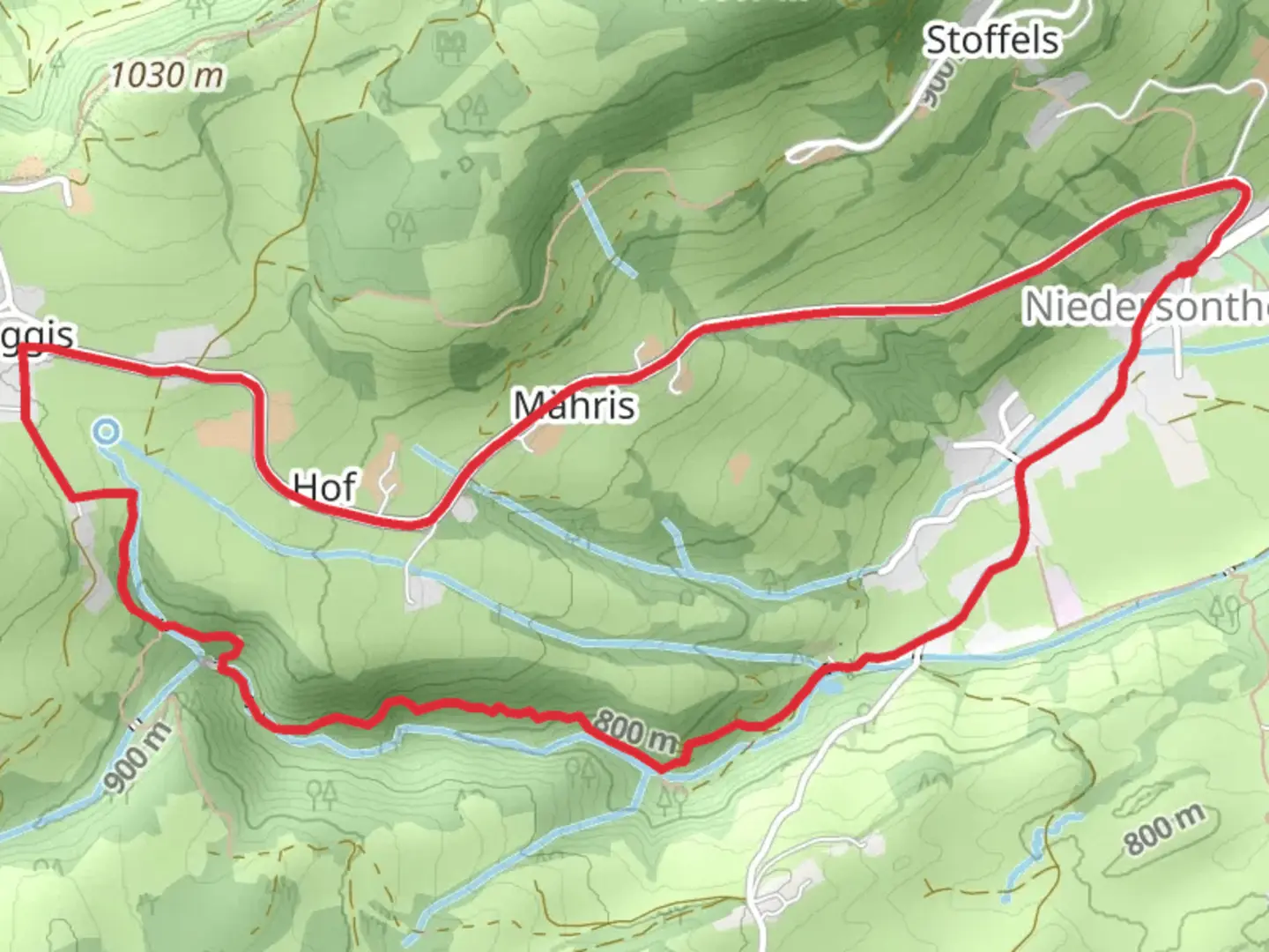
“Discover scenic views, waterfalls, and historical ruins on the Falltobelweg loop trail in Oberallgäu, Germany.”
Starting your hike near Oberallgäu, Germany, the Falltobelweg from Niedersonthofen is a delightful loop trail that spans approximately 7 km (4.3 miles) with an elevation gain of around 200 meters (656 feet). This medium-difficulty trail offers a mix of scenic beauty, historical significance, and natural wonders, making it a rewarding experience for hikers of various skill levels.### Getting There To reach the trailhead, you can either drive or use public transport. If you're driving, set your GPS to Niedersonthofen, Oberallgäu, Germany. For those opting for public transport, take a train to Immenstadt and then a bus to Niedersonthofen. The trailhead is conveniently located near the village, making it easily accessible.### Trail Highlights
Scenic Views and Natural Beauty
As you embark on the trail, you'll be greeted by lush forests and rolling meadows. The initial part of the hike takes you through dense woodland, where the canopy provides a cool, shaded environment. Keep an eye out for local wildlife such as deer and various bird species that inhabit the area.#### Waterfalls and Streams One of the most captivating features of this trail is the series of small waterfalls and streams you'll encounter. The sound of cascading water adds a serene backdrop to your hike. These natural water features are particularly picturesque during the spring and early summer when water levels are higher.#### Historical Significance The region around Oberallgäu has a rich history, and you'll find remnants of old mills and farmhouses along the trail. These structures offer a glimpse into the area's past, where agriculture and milling were once the primary livelihoods. Take a moment to appreciate the craftsmanship and imagine life in a bygone era.### Navigation and Waypoints Using HiiKER for navigation is highly recommended. The app provides detailed maps and waypoints, ensuring you stay on track. Key waypoints to look out for include:- Niedersonthofen Village: The starting point of your hike. - Waterfall Junction: Approximately 3 km (1.9 miles) into the hike, where you can take a short detour to view a stunning waterfall. - Old Mill Ruins: Around 5 km (3.1 miles) into the hike, offering a historical pause.### Flora and Fauna The trail is rich in biodiversity. In the spring and summer months, you'll find a variety of wildflowers, including orchids and lilies. The forested sections are home to oak, beech, and pine trees. Wildlife enthusiasts may spot red foxes, badgers, and a variety of bird species, including woodpeckers and owls.### Elevation and Terrain The trail features a moderate elevation gain of 200 meters (656 feet), making it accessible yet challenging enough to be rewarding. The terrain varies from well-trodden paths to rocky sections, so sturdy hiking boots are recommended. There are a few steep inclines, particularly near the waterfall junction, but these are manageable with a moderate level of fitness.### Practical Information - Best Time to Hike: Late spring to early autumn offers the best weather conditions. - Facilities: There are no restrooms or water refill stations along the trail, so plan accordingly. - Safety Tips: Always check the weather forecast before heading out and carry a basic first aid kit.This trail offers a perfect blend of natural beauty, historical intrigue, and moderate physical challenge, making it a must-visit for any hiking enthusiast exploring the Oberallgäu region.

What to expect?
Activity types
Comments and Reviews
User comments, reviews and discussions about the Falltobelweg from Niedersonthofen, Germany.
4.0
average rating out of 5
2 rating(s)