Download
Preview
Add to list
More
4.0 km
~1 hrs 0 min
131 m
Loop
“Experience the serene beauty of Eschacher Weiher Loop, a 4 km trail with lush forests and open meadows.”
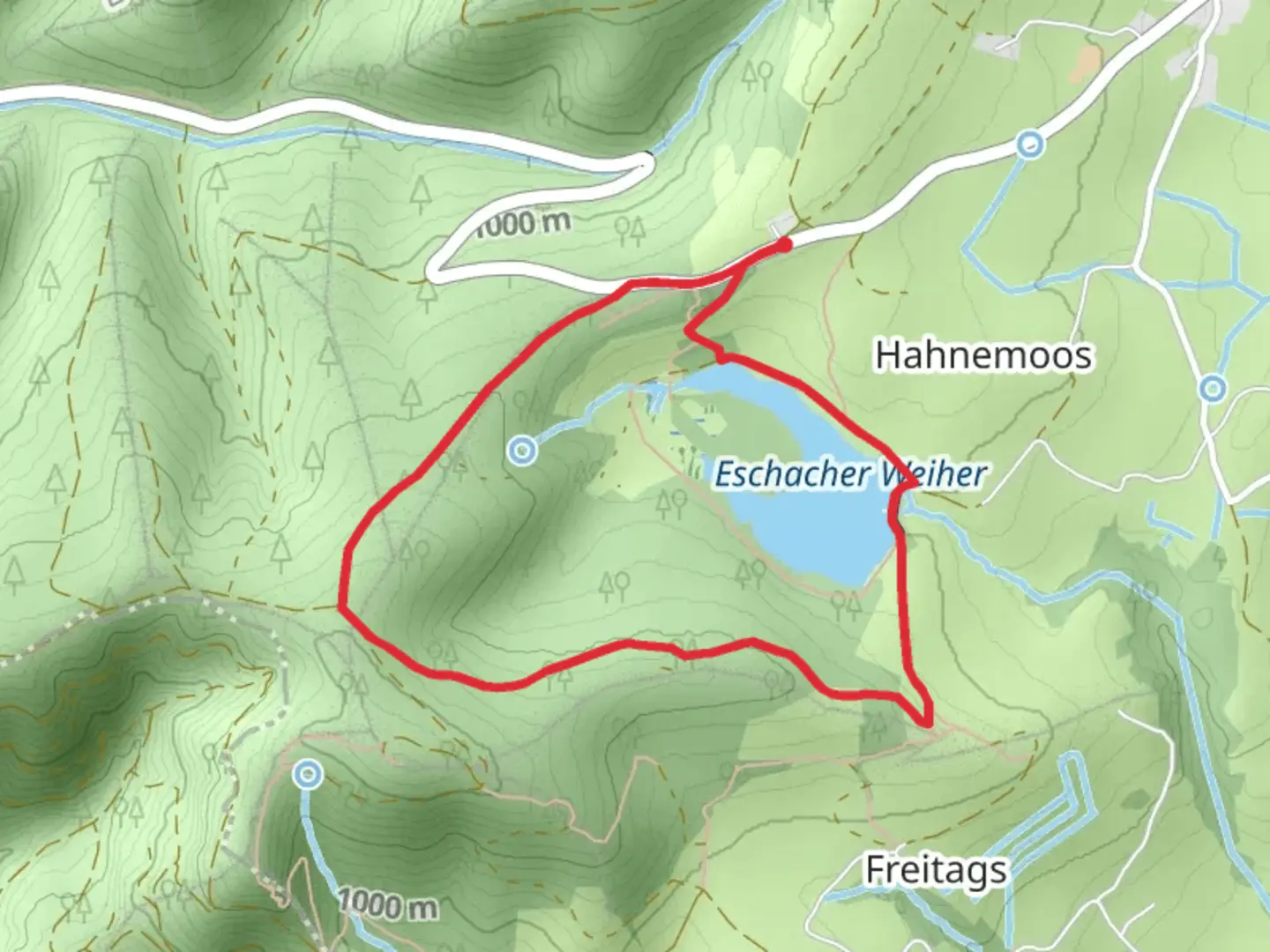
Starting near the picturesque region of Oberallgäu in Germany, the Eschacher Weiher Loop is a delightful 4 km (2.5 miles) trail with an elevation gain of approximately 100 meters (328 feet). This loop trail offers a moderate challenge, making it suitable for hikers with some experience.### Getting There To reach the trailhead, you can drive or use public transport. If driving, set your GPS to the nearest known address: Eschacher Weiher, 87488 Betzigau, Germany. For those using public transport, take a train to Kempten (Allgäu) Hauptbahnhof and then a local bus towards Betzigau. From Betzigau, it's a short walk to the trailhead.### Trail Overview The trail begins near the serene Eschacher Weiher, a small lake surrounded by lush greenery. As you start your hike, you'll be greeted by a well-marked path that meanders through dense forests and open meadows. The initial section is relatively flat, allowing you to ease into the hike while enjoying the tranquil surroundings.### Key Landmarks and Points of Interest - Eschacher Weiher: At the very start, take a moment to appreciate the calm waters of Eschacher Weiher. This lake is a popular spot for locals, especially during the summer months. - Forested Areas: About 1 km (0.6 miles) into the hike, you'll enter a dense forest. The canopy provides ample shade, making this section particularly enjoyable during warmer days. Keep an eye out for local wildlife such as deer and various bird species. - Open Meadows: Around the 2 km (1.2 miles) mark, the trail opens up into expansive meadows. These areas offer stunning views of the surrounding Allgäu Alps. This is a great spot to take a break and soak in the scenery. - Historical Significance: The region around Oberallgäu has a rich history dating back to medieval times. While the trail itself doesn't pass any specific historical landmarks, the nearby town of Kempten is one of the oldest urban settlements in Germany, with roots tracing back to Roman times.### Elevation and Terrain The trail features a gradual elevation gain of about 100 meters (328 feet). The ascent is spread out over the course of the hike, making it manageable for most hikers. The terrain varies from well-trodden dirt paths to grassy meadows and occasional rocky sections. Good hiking boots are recommended for added comfort and stability.### Navigation To ensure you stay on track, consider using the HiiKER app, which provides detailed maps and real-time navigation. The trail is well-marked, but having a reliable navigation tool can enhance your hiking experience.### Flora and Fauna The Eschacher Weiher Loop is a haven for nature enthusiasts. The forested sections are home to a variety of tree species, including oak, beech, and pine. In the meadows, you'll find an array of wildflowers, especially vibrant during the spring and summer months. Wildlife sightings are common, with deer, foxes, and numerous bird species frequently spotted along the trail.### Final Stretch As you near the end of the loop, the trail gently descends back towards Eschacher Weiher. The final stretch offers a mix of forest and open areas, providing a pleasant and varied end to your hike. Upon completing the loop, consider spending some time by the lake, perhaps enjoying a picnic or simply relaxing by the water.This trail offers a perfect blend of natural beauty, moderate challenge, and historical context, making it a rewarding experience for any hiker.

What to expect?
Activity types
Comments and Reviews
User comments, reviews and discussions about the Eschacher Weiher Loop, Germany.
4.33
average rating out of 5
3 rating(s)