Download
Preview
Add to list
More
6.6 km
~1 hrs 40 min
218 m
Loop
“Discover a scenic 7 km loop trail near Neukirchen, blending lush forests, historical ruins, and panoramic views.”
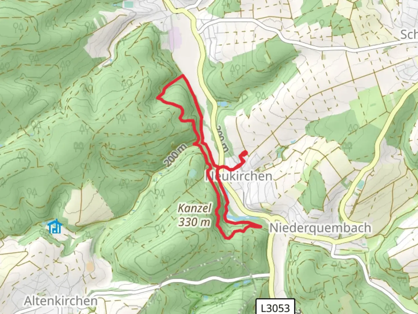
Starting near Lahn-Dill-Kreis in Germany, this 7 km (approximately 4.35 miles) loop trail offers a delightful mix of natural beauty and moderate challenge, making it perfect for hikers looking for a rewarding day out. With an elevation gain of around 200 meters (656 feet), the trail provides a good workout without being overly strenuous.
Getting There To reach the trailhead, you can drive or use public transport. If driving, set your GPS to Neukirchen, Lahn-Dill-Kreis, Germany. For those using public transport, the nearest significant landmark is the town of Herborn. From Herborn, you can take a local bus to Neukirchen, which is a short ride away.
Trail Overview The trail begins near the outskirts of Neukirchen, a quaint village that offers a glimpse into traditional German rural life. As you start your hike, you'll be greeted by well-marked paths that meander through lush forests and open meadows. The initial part of the trail is relatively flat, making it an excellent warm-up for the more challenging sections ahead.
Key Landmarks and Sections #### Forested Pathways About 1.5 km (0.93 miles) into the hike, you'll enter a dense forest area. The canopy overhead provides ample shade, making this section particularly enjoyable during warmer months. Keep an eye out for local wildlife such as deer and various bird species. The forest floor is often dotted with wildflowers, adding a splash of color to your journey.
#### Scenic Overlook At around the 3 km (1.86 miles) mark, you'll reach a scenic overlook that offers panoramic views of the surrounding countryside. This is an excellent spot to take a break, hydrate, and snap some photos. The elevation gain to this point is gradual but noticeable, so take your time and enjoy the scenery.
#### Historical Significance As you continue, you'll come across remnants of old stone structures, indicative of the region's historical significance. These ruins are believed to date back to medieval times when the area was a hub for local trade and agriculture. The trail here is well-marked, but it's always a good idea to have a reliable navigation tool like HiiKER to ensure you stay on track.
Final Stretch The last 2 km (1.24 miles) of the trail loop back towards Neukirchen. This section is mostly downhill, offering a gentle descent through more open meadows and farmland. The views here are expansive, providing a perfect end to your hike. As you approach the village, you'll pass by several Wochenendhäuser (weekend houses), which are small, charming cottages used by locals for weekend getaways.
Wildlife and Flora Throughout the hike, you'll encounter a variety of flora and fauna. The forests are home to oak, beech, and pine trees, while the meadows are rich with wildflowers and grasses. Wildlife sightings may include deer, foxes, and a variety of bird species, making this trail a nature lover's paradise.
Preparation Tips Given the moderate difficulty rating, it's advisable to wear sturdy hiking boots and bring plenty of water. The trail is well-maintained, but weather conditions can affect the terrain, so check the forecast before heading out. A map on HiiKER can be invaluable for navigation, especially if you're unfamiliar with the area.
This loop trail near Neukirchen offers a perfect blend of natural beauty, moderate challenge, and historical intrigue, making it a must-visit for any hiking enthusiast.

What to expect?
Activity types
Comments and Reviews
User comments, reviews and discussions about the Wochenendhäuser Loop via Neukirchen, Germany.
4.33
average rating out of 5
3 rating(s)