Download
Preview
Add to list
More
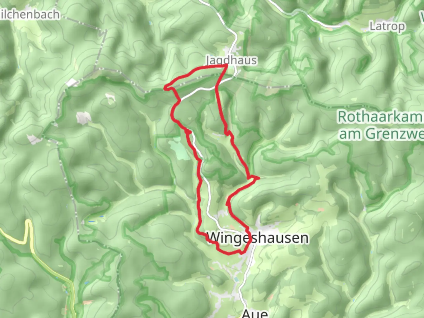
13.3 km
~3 hrs 17 min
381 m
Loop
“Embark on the Rothaarsteig Spur Wisent Pfad for 13 km of enchanting nature, wildlife, and history.”
Starting near Kreis Siegen-Wittgenstein, Germany, the Rothaarsteig Spur Wisent Pfad is a captivating 13 km (8 miles) loop trail with an elevation gain of approximately 300 meters (984 feet). This medium-difficulty trail offers a blend of natural beauty, wildlife, and historical significance, making it a rewarding experience for hikers.
Getting There To reach the trailhead, you can drive or use public transport. If driving, set your GPS to Kreis Siegen-Wittgenstein, Germany. For those using public transport, the nearest significant landmark is the town of Bad Berleburg. From there, local buses or taxis can take you to the trailhead.
Trail Highlights The trail begins with a gentle ascent through dense forests, offering a serene start to your hike. As you progress, you'll encounter the first significant landmark, the Wisent Wildnis, approximately 3 km (1.86 miles) into the hike. This area is home to a herd of European bison, or wisents, which were reintroduced to the region as part of a conservation project. Keep your eyes peeled for these majestic creatures grazing in their natural habitat.
Flora and Fauna The trail is rich in biodiversity. You'll traverse through mixed forests of beech, oak, and spruce, providing ample shade and a cool environment. Birdwatchers will be delighted by the variety of species, including woodpeckers, owls, and songbirds. Small mammals like foxes and deer are also commonly spotted along the trail.
Historical Significance Around the 7 km (4.35 miles) mark, you'll come across the remnants of ancient Celtic fortifications. These ruins date back to the Iron Age and offer a glimpse into the region's historical significance. Interpretive signs provide information about the site's history and its role in ancient times.
Navigation and Safety The trail is well-marked with signs and blazes, but it's always a good idea to have a reliable navigation tool. The HiiKER app is highly recommended for this trail, offering detailed maps and real-time GPS tracking to ensure you stay on course.
Scenic Views As you reach the highest point of the trail, around 9 km (5.59 miles) in, you'll be rewarded with panoramic views of the Rothaar Mountains. This is an excellent spot for a break and some photography. The elevation gain here is about 200 meters (656 feet) from the trailhead, making it a moderate climb.
Final Stretch The descent takes you through more open landscapes, including meadows and small streams. The final 4 km (2.48 miles) are relatively easy, allowing you to enjoy the scenery at a leisurely pace. You'll loop back to the starting point, completing your 13 km (8 miles) journey.
Practical Tips - Wear sturdy hiking boots, as the trail can be uneven in places. - Bring enough water and snacks, especially if you plan to take breaks and enjoy the scenery. - Check the weather forecast before heading out, as conditions can change rapidly in the mountains. - Be mindful of wildlife and maintain a respectful distance, especially from the wisents.
This trail offers a perfect blend of natural beauty, wildlife encounters, and historical intrigue, making it a must-visit for any hiking enthusiast.

Comments and Reviews
User comments, reviews and discussions about the Rothaarsteig Spur Wisent Pfad, Germany.
4.5
average rating out of 5
4 rating(s)